File:East-Hem_1025ad.jpg
From Wikipedia, the free encyclopedia
Pôvodný súbor (3 240 × 1 903 pixelov, veľkosť súboru: 3,16 MB, MIME typ: image/jpeg)
Tento zdieľaný súbor je z Wikimedia Commons a je možné ho používať na iných projektoch. Nižšie sú zobrazené informácie z popisnej stránky súboru.

|
Tento obrázek (skupina historical map) by měl být vytvořen pomocí vektorové grafiky jako SVG soubor. To má několik výhod; podrobnosti najdete na stránce Commons:Media for cleanup. Je-li SVG verze tohoto obrázku již k dispozici, prosím nahrajte ji. Po nahrání nahraďte tuto šablonu šablonou {{Vector version available|jméno nového obrázku.svg}}.
|
 | Tento obrázek (nebo všechny obrázky v tomto článku či kategorii) byl nahrán ve formátu JPEG, ačkoliv obsahuje informace, které mohou být efektivněji nebo přesněji uloženy ve formátu PNG nebo SVG. Pokud je to možné, nahrajte prosím variantu tohoto obrázku v PNG či SVG bez kompresních artefaktů buď z ne-JPEG zdroje nebo s odstraněnými kompresními artefakty. |  |
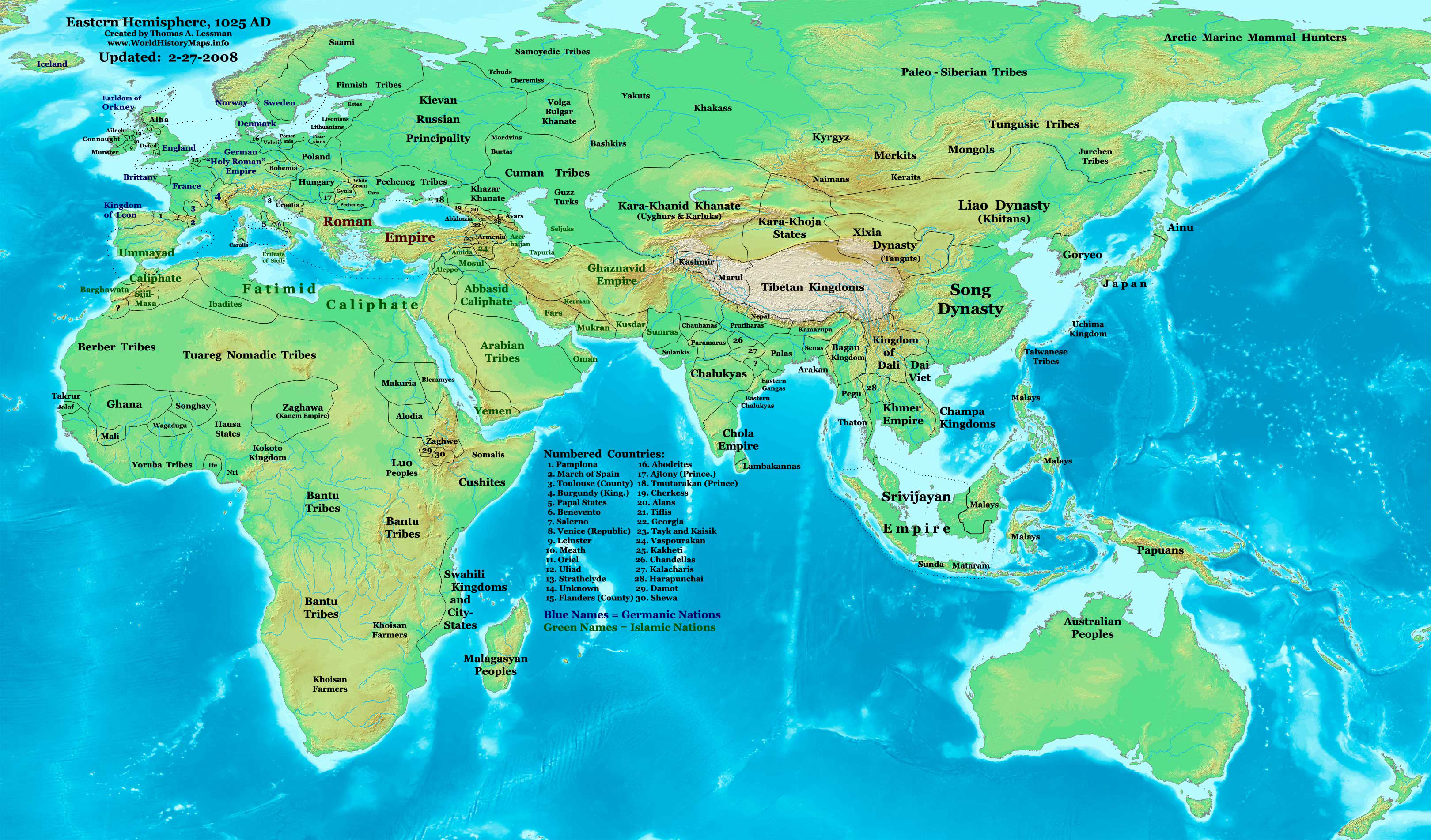
| PopisEast-Hem 1025ad.jpg | Eastern Hemisphere in 1025 AD. |
| Zdroj | self-made (For reference information, see the Map Source References section below.) |
| Autor | Thomas Lessman (Contact!) |
| Povolenie (Využívanie tohto súboru) |
Ja, držiteľ autorských práv k tomuto dielu ho týmto zverejňujem za podmienok nasledovnej licencie: Tento súbor podlieha licencii Creative Commons Attribution-Share Alike 3.0 Unported
|
| Ďalšie verzie | see East-Hem_1025ad.jpg file history on Wikipedia. |
Obsah
Map Summary
Original Source URL: http://www.thomaslessman.com/History/images/East-Hem_1025ad.jpg.
This map of the Eastern Hemisphere in 1025 AD was created by Thomas Lessman, based on information from the sources listed below. This map is free for educational use (see Permission info above). When using this map, please mention that it is available for free at www.WorldHistoryMaps.info.
Map Source References
- Remember, sources often conflict with each other. This map is only as accurate as the information that is available to me. To report any errors or to help further this work, please click here, or email Thomas Lessman at talessman@yis.us
References for information contained in this map:
1. Borders of Europe are mostly derived from the www.Euratlas.com map of Europe in 1000 AD.
- (Please note: Bogomolov.PL has done a great job of showing me possible discrepancies in my north European borders compared to this source, due to the differences in the geographical layout of the maps.)
2. Borders of Asian countries derive from various Wikipedia articles and Google history map searches.
3. Fringe areas like Africa, Australia, Siberia, etc. derive from various articles in Wikipedia.
4. Much of the information in this map was cross-checked with Bruce Gordon's Regnal Chronologies.
Other Maps by Thomas Lessman
| Maps of the eastern hemisphere showing history
Bold dates are available on Wikimedia or Wikipedia. | ||
| Primeval | ||
| Ancient
|
·| 600 BC | 550 BC | 527 BC | 500 BC |
400 BC | ·| 1 AD | 50 AD | 100 AD | 200 AD | 300 AD | | |
| Medieval |
·| 500 AD | 565 AD | 600 AD | 700 AD | | |
| Modern |
·| 1500 AD | · * For historical maps of the whole world, | |
| history links talk edit view | ||
Pôvodný záznam nahrávaní
- 2008-01-21 22:17 Talessman 3240×1903×8 (795129 bytes) Corrected borders of Southeast Asia, Africa, Scandinavia, and added more info for East Asia and Africa.
- 2007-12-05 20:33 Talessman 3240×1903×8 (774637 bytes) Corrected borders for Mongolia, added names of smaller countries (with numbered legend), added more info for Africa, corrected information for Indonesia.
- 2007-11-09 15:14 Talessman 3240×1903×8 (727501 bytes) Corrected borders of Srivijaya, Sudan, and Ethiopia, also added info on other African tribes and nations, also added info for far eastern islands.
- 2007-09-26 16:26 Talessman 2880×1692×8 (571380 bytes) Author: Thomas A. Lessman. Source URL: http://www.ThomasLessman.com/History/images/East-Hem_1025ad.jpg. Image was created by me (Thomas Lessman) based on historical information located on Wikipedia, as well as information from maps located in Wikipedia an
- 2007-09-12 21:54 Talessman 2880×1692×8 (558662 bytes) Author: Thomas A. Lessman. Source URL: http://www.ThomasLessman.com/History/images/East-Hem_1025ad.jpg. Image was created by me (Thomas Lessman) based on historical information located on Wikipedia, as well as information from maps located in Wikipedia an
Štítky
Položky prezentované týmto súborom
motív
Nějaká hodnota bez položky na Wikidata
História súboru
Po kliknutí na dátum/čas uvidíte ako súbor vyzeral vtedy.
| Dátum/Čas | Náhľad | Rozmery | Používateľ | Komentár | |
|---|---|---|---|---|---|
| aktuálna | 11:09, 16. január 2009 | | 3 240 × 1 903 (3,16 MB) | Ukabia | {{Information |Description= |Source= |Date= |Author= |Permission= |other_versions= }} |
| 21:27, 9. máj 2008 |  | 3 240 × 1 903 (778 KB) | Talessman | {{Information |Description=Eastern Hemisphere in 1025 AD. |Source=self-made |Author=User:Talessman |Permission={{self|cc-by-sa-3.0}} }} |
Použitie súboru
Žiadne stránky neobsahujú odkazy na tento súbor.
Globálne využitie súborov
Nasledovné ďalšie wiki používajú tento súbor:
- Použitie na ar.wikipedia.org
- Použitie na arz.wikipedia.org
- Použitie na azb.wikipedia.org
- Použitie na be.wikipedia.org
- Použitie na bs.wikipedia.org
- Použitie na ceb.wikipedia.org
- Použitie na de.wikiversity.org
- Použitie na en.wikipedia.org
- 11th century
- User:Tompw/sandbox10
- User:Talessman/Maps
- User talk:Talessman/Maps
- User:Benjamin Trovato/sandbox
- List of states during the Middle Ages
- List of political entities in the 11th century
- User:Navops47/sandbox10
- List of countries by population in 1000
- Champa–Đại Cồ Việt war (982)
- User:Falcaorib/Ancient East Hemisphere
- Použitie na es.wikipedia.org
- Použitie na fa.wikipedia.org
- Použitie na fr.wikipedia.org
- Použitie na gl.wikipedia.org
- Použitie na he.wikipedia.org
- Použitie na hu.wikipedia.org
- Použitie na io.wikipedia.org
- Použitie na lt.wikipedia.org
- Použitie na mk.wikipedia.org
- Použitie na mr.wikipedia.org
- Použitie na my.wikipedia.org
- Použitie na pnb.wikipedia.org
- Použitie na ps.wikipedia.org
- Použitie na ro.wikipedia.org
- Použitie na rue.wikipedia.org
- Použitie na ru.wikipedia.org
- Použitie na shn.wikipedia.org
- Použitie na si.wikipedia.org
- Použitie na sv.wikipedia.org
- Použitie na sw.wikipedia.org
- Použitie na tg.wikipedia.org
- Použitie na th.wikipedia.org
- Použitie na tl.wikipedia.org
- Použitie na ur.wikipedia.org
Zobraziť ďalšie globálne použitie tohto súboru.
Metadáta
Tento súbor obsahuje ďalšie informácie, pravdepodobne pochádzajúce z digitálneho fotoaparátu či skenera, ktorý ho vytvoril alebo digitalizoval. Ak bol súbor zmenený, niektoré podrobnosti sa nemusia plne zhodovať so zmeneným súborom.
| Orientácia | Normálna |
|---|---|
| Horizontálne rozlíšenie | 72 dpi |
| Vertikálne rozlíšenie | 72 dpi |
| Použitý softvér | Adobe Photoshop CS3 Macintosh |
| Dátum a čas zmeny súboru | 11:07, 16. január 2009 |
| Farebný priestor | Nekalibrované |