Fil:The_West_Virginia_Capitol_in_Charleston_LCCN2015631770.tif
From Wikipedia, the free encyclopedia
Originalfil (4 660 × 4 318 pixlar, filstorlek: 115,21 Mbyte, MIME-typ: image/tiff)
| Denna fil tillhandahålls av Wikimedia Commons. Informationen nedan är kopierad från dess filbeskrivningssida. |
Sammanfattning
| BeskrivningThe West Virginia Capitol in Charleston LCCN2015631770.tif |
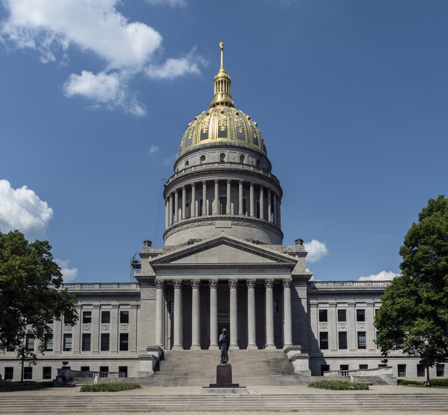
English: Title: The West Virginia Capitol in Charleston
Physical description: 1 photograph : digital, tiff file, color. Notes: Purchase; Carol M. Highsmith Photography, Inc.; 2015; (DLC/PP-2015:055).; For several years, the capital of West Virginia intermittently traveled between Wheeling and Charleston. In 1877, however, the state's citizens voted on the final location of their capital. Charleston was chosen and, eight years later, the first capitol building was opened. After a fire in 1921, a hastily-built structure was opened but it too burned down in 1927. A Capitol Building Commission, created by the Legislature in 1921, authorized construction of the present capitol, which is 10 feet taller than the U.S. Capitol in Washington. Architect Cass Gilbert designed the buff limestone structure that was to have a final cost of just under $10 million. After the three stages of construction were completed, Governor William G. Conley dedicated the capitol on June 20, 1932.; Forms part of: West Virginia Collection within the Carol M. Highsmith Archive.; Title, date and keywords based on information provided by the photographer.; Credit line: West Virginia Collection within the Carol M. Highsmith Archive, Library of Congress, Prints and Photographs Division. |
||||||||||||||||||||||||||
| Datum | Bild tagen: 6 maj 2015, 15:17 (enligt filens Exif‐data) | ||||||||||||||||||||||||||
| Källa |
Library of Congress
|
||||||||||||||||||||||||||
| Skapare |
creator QS:P170,Q5044454 |
||||||||||||||||||||||||||
| Tillstånd (Återanvändning av denna fil) |
No known restrictions on publication.
|
||||||||||||||||||||||||||


| Kameraposition | 38° 20′ 07,37″ N, 81° 36′ 46,5″ V | Se denna och andra närliggande bilder på: OpenStreetMap |
|---|
Licensiering
| Public domainPublic domainfalsefalse |
| This work is from the Carol M. Highsmith Archive collection at the Library of Congress. According to the library, there are no known copyright restrictions on the use of this work. Carol M. Highsmith has stipulated that her photographs are in the public domain. Photographs of sculpture or other works of art may be restricted by the copyright of the artist. |
 |
Bildtexter
Objekt som porträtteras i den här filen
motiv
38°20'7.368"N, 81°36'46.501"W
Filhistorik
Klicka på ett datum/klockslag för att se filen som den såg ut då.
| Datum/Tid | Miniatyrbild | Dimensioner | Användare | Kommentar | |
|---|---|---|---|---|---|
| nuvarande | 30 september 2016 kl. 00.47 |  | 4 660 × 4 318 (115,21 Mbyte) | Fæ | LOC 2015631770, Carol M. Highsmith collection. P164.23252 TIFF (115.2mb) |
Filanvändning
Följande 2 sidor använder den här filen:
Global filanvändning
Följande andra wikier använder denna fil:
- Användande på de.wikipedia.org
- Användande på de.wikivoyage.org
- Användande på en.wikipedia.org
- Användande på es.wikipedia.org
- Användande på hu.wikipedia.org
- Användande på uk.wikipedia.org
- Användande på www.wikidata.org
- Användande på zh.wikipedia.org
Metadata
Den här filen innehåller extrainformation som troligen lades till av en digitalkamera eller skanner när filen skapades. Om filen har modifierats kan det hända att vissa detaljer inte överensstämmer med den modifierade filen.
| Bildtitel | http://hdl.loc.gov/loc.pnp/pnpdigacq_2015_055_sip2.WVA_4176.tif |
|---|---|
| Kameratillverkare | NIKON CORPORATION |
| Kameramodell | NIKON D810 |
| Skapare | Library of Congress; P&P |
| Exponeringstid | 1/400 sek (0,0025) |
| Bländartal | f/10 |
| Filmhastighet (ISO) | 100 |
| Exponeringstidpunkt | 6 maj 2015 kl. 15.17 |
| Linsens brännvidd | 24 mm |
| Latitud | 38° 20′ 7,37″ N |
| Longitud | 81° 36′ 46,5″ W |
| Höjd | 172 meter över havet |
| Bredd | 4 660 px |
| Höjd | 4 318 px |
| Bitar per komponent |
|
| Komprimeringsalgoritm | Inte komprimerad |
| Pixelsammansättning | RGB |
| Orientering | Normal |
| Antal komponenter | 3 |
| Antal rader per strip | 1 |
| Upplösning i horisontalplan | 300 dpi |
| Vertikal upplösning | 300 dpi |
| Dataarrangemang | chunkformat |
| Använd mjukvara | NIKON D810 Ver.1.02 |
| Ändringstidpunkt | 6 maj 2015 kl. 20.46 |
| Exponeringsprogram | Manuell inställning |
| Exif-version | 2.21 |
| Datum och tidpunkt för digitalisering | 6 maj 2015 kl. 15.17 |
| APEX slutarhastighet | 8,643856 |
| APEX bländare | 6,643856 |
| Exponeringsbias | 0 |
| Maximal bländare | 3 APEX (f/2,83) |
| Mätmetod | Mönster |
| Ljuskälla | Okänd |
| Blixt | Blixten utlöstes ej, blixten avstängd |
| Exponeringstidpunkt, sekunddelar | 67 |
| Färgrymd | Icke-kalibrerad |
| Upplösning i fokalplan x | 2 048,4022216797 |
| Upplösning i fokalplan y | 2 048,4022216797 |
| Enhet för upplösning i fokalplan | 3 |
| Avkänningsmetod | Enchipsfärgsensor |
| Filkälla | Digital stillbildskamera |
| Scentyp | Direkt fotograferad bild |
| Anpassad bildbehandling | Normal |
| Exponeringsläge | Manuell exponering |
| Vitbalans | Automatisk vitbalans |
| Digitalt zoomomfång | 1 |
| Brännvidd på 35 mm film | 24 mm |
| Motivprogram | Standard |
| Bildförstärkning | Ingen |
| Kontrast | Normal |
| Mättnad | Normal |
| Skärpa | Normal |
| Avståndsintervall till motiv | Okänd |
| GPS-tid (atomur) | 19.17 |
| Satelliter använda för mätning | 06 |
| Använd geodetisk data | WGS84 |
| GPS-datum | 6 maj 2015 |
| Version för GPS-taggar | 0.0.3.2 |