File:Www.wesleyjohnston.com-users-ireland-maps-historical-map1014.gif
From Wikipedia, the free encyclopedia
Daha yüksek çözünürlüğe sahip sürüm bulunmamaktadır.
Www.wesleyjohnston.com-users-ireland-maps-historical-map1014.gif ((466 × 582 piksel, dosya boyutu: 10 KB, MIME tipi: image/gif))
Bu dosya Wikimedia Commons'ta bulunmaktadır. Dosyanın açıklaması aşağıda gösterilmiştir. Commons, serbest/özgür telifli medya dosyalarının bulundurulduğu depodur. Siz de yardım edebilirsiniz. |
Özet
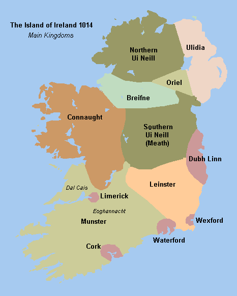
Historical map of Ireland circa 1014 from http://www.wesleyjohnston.com/users/ireland/maps/historical/map1014.gif


 | This image was uploaded as GIF, while a different format would have been more suitable. Commons discourages the use of GIF files, except for animations. See Commons:File types for more information.
If possible, please upload a PNG version (or JPEG for some photos) of this image, and mark the GIF image as {{Superseded|‹new image name›}}. If you like, encourage other Wikimedia projects using the GIF to use the new version instead. If this image is a diagram or other image suitable for vectorisation, please tag this image with {{Convert to SVG}} instead of {{BadGIF}}. If not suitable for vectorisation, use {{Convert to PNG}}. For more information, see {{BadGIF}}. беларуская (тарашкевіца) ∙ català ∙ čeština ∙ Deutsch ∙ English ∙ español ∙ فارسی ∙ suomi ∙ français ∙ עברית ∙ magyar ∙ italiano ∙ 日本語 ∙ македонски ∙ മലയാളം ∙ Plattdüütsch ∙ Nederlands ∙ português ∙ русский ∙ sicilianu ∙ українська ∙ 中文 ∙ 简体中文 ∙ 繁體中文 ∙ 台灣正體 ∙ +/− |
Lisanslama

|
Bu dosyanın telif hakkı sahibi, The Ireland Story, telif hakkına uygun şekilde atıfta bulunmak koşuluyla herkese herhangi bir amaç için bu çalışmayı kullanmak üzere izin vermiştir. |
Atıf:
The Ireland Story Attribution |
Altyazılar
Bu dosyanın temsil ettiği şeyin tek satırlık açıklamasını ekleyin.
Bu dosyada gösterilen öğeler
betimlenen
image/gif
Dosya geçmişi
Dosyanın herhangi bir zamandaki hâli için ilgili tarih/saat kısmına tıklayın.
| Tarih/Saat | Küçük resim | Boyutlar | Kullanıcı | Yorum | |
|---|---|---|---|---|---|
| güncel | 18.49, 29 Ağustos 2009 | | 466 × 582 (10 KB) | The Illusional Ministry | Fixed borders and colours. |
| 18.25, 30 Kasım 2006 |  | 466 × 582 (13 KB) | Electionworld | {{PD-because|see image}} |
Dosya kullanımı
Bu görüntü dosyasına bağlanan sayfa yok.
Küresel dosya kullanımı
Aşağıdaki diğer vikiler bu dosyayı kullanır:
- ar.wikipedia.org üzerinde kullanımı
- be.wikipedia.org üzerinde kullanımı
- ca.wikipedia.org üzerinde kullanımı
- cs.wikipedia.org üzerinde kullanımı
- de.wikipedia.org üzerinde kullanımı
- en.wikipedia.org üzerinde kullanımı
- Connacht
- Battle of Clontarf
- List of Irish kingdoms
- Portal:Ireland
- Domnall Ua Lochlainn
- Muirchertach Ua Briain
- History of Ireland (1169–1536)
- Treaty of Windsor (1175)
- Talk:Ulaid
- Kingdom of Breifne
- Gaelic Ireland
- User talk:Fergananim/ArchiveIV
- Donnchad mac Briain
- Ruaidrí na Saide Buide Ua Conchobair
- User:Angusmclellan/Muirchertach Ua Briain
- Wikipedia:Reference desk/Archives/Humanities/2009 February 21
- User:Mrchris/Timeline of County Kilkenny
- History of Ireland
- Wikipedia talk:WikiProject Northern Ireland/Archive 1
- es.wikipedia.org üzerinde kullanımı
- eu.wikipedia.org üzerinde kullanımı
- fa.wikipedia.org üzerinde kullanımı
- fi.wikipedia.org üzerinde kullanımı
- fr.wikipedia.org üzerinde kullanımı
- ga.wikipedia.org üzerinde kullanımı
- gl.wikipedia.org üzerinde kullanımı
Bu dosyanın daha fazla küresel kullanımını görüntüle.
"https://tr.wikipedia.org/wiki/Dosya:Www.wesleyjohnston.com-users-ireland-maps-historical-map1014.gif" sayfasından alınmıştır