Файл:Qin_empire_210_BCE.jpg
З Вікіпедії, безкоштовно encyclopedia
Qin_empire_210_BCE.jpg (555 × 545 пікселів, розмір файлу: 298 КБ, MIME-тип: image/jpeg)
| Відомості про цей файл містяться на Вікісховищі — централізованому сховищі вільних файлів мультимедіа для використання у проектах Фонду Вікімедіа. |
Опис файлу
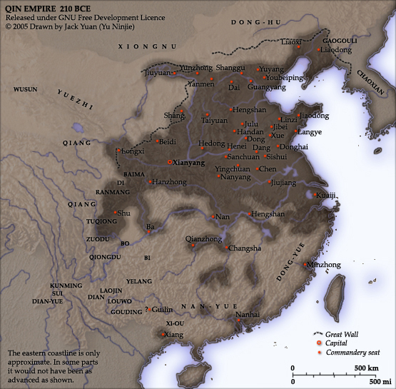
From english Wikipedia:
As part of his unification of China in 221 BC, Qin Shi Huang divided his empire into thirty six commanderies, each subdivided into an number of counties. The significance of the administrative reforms was its introduction of a uniformly centralised system of imperial control. The system was followed by the Han Dynasty, though with a certain degree of compromise. Thereafter, the system became the norm for later dynasties and eventually evolved into the present administrative structure of Mainland China. See: Political divisions of China.
The location of the Yellow River and commandery seats follows Tan Qixiang (ed.), Zhongguo lishi ditu (中国历史地图集), 1982. Note that the Yellow River is considerably to the north of its present flow.
The coloured territories show the approximate extent of Qin political control at the death of Qin Shi Huang in 210 BC. At that time more commanderies were added to the original thirty six, and these are also shown on the map.
Created and copyright (2005) by Yu Ninjie. Released under the GNU Free Documentation License.
Ліцензування

|
Дозволяється копіювати, розповсюджувати та/або модифікувати цей документ на умовах ліцензії GNU FDL версії 1.2 або більш пізньої, виданої Фондом вільного програмного забезпечення, без незмінних розділів, без текстів, які розміщені на першій та останній обкладинці. Копія ліцензії знаходиться у розділі GNU Free Documentation License.http://www.gnu.org/copyleft/fdl.htmlGFDLGNU Free Documentation Licensetruetrue |
| Цей файл ліцензований на умовах Creative Commons Attribution-Share Alike 3.0 Unported | ||
| ||
| Цей шаблон ліцензування був доданий до файлу в рамках оновлення ліцензії GFDL.http://creativecommons.org/licenses/by-sa/3.0/CC BY-SA 3.0Creative Commons Attribution-Share Alike 3.0truetrue |
Підписи
Об'єкти, показані на цьому файлі
зображує
Історія файлу
Клацніть на дату/час, щоб переглянути, як тоді виглядав файл.
| Дата/час | Мініатюра | Розмір об'єкта | Користувач | Коментар | |
|---|---|---|---|---|---|
| поточний | 17:08, 2 вересня 2005 | | 555 × 545 (298 КБ) | David.gaya | From english Wikipedia: As part of his unification of China in 221 BC, Qin Shi Huang divided his empire into thirty six commanderies, each subdivided into an number of counties. The significance of the administrative reforms wa |
Використання файлу
Такі сторінки використовують цей файл:
Глобальне використання файлу
Цей файл використовують такі інші вікі:
- Використання в als.wikipedia.org
- Використання в ar.wikipedia.org
- Використання в azb.wikipedia.org
- Використання в ba.wikipedia.org
- Використання в be.wikipedia.org
- Використання в bn.wikipedia.org
- Використання в ce.wikipedia.org
- Використання в de.wikipedia.org
- Використання в el.wikipedia.org
- Використання в en.wikipedia.org
- Використання в en.wikiversity.org
- Використання в es.wikipedia.org
- Використання в et.wikipedia.org
- Використання в fi.wikipedia.org
- Використання в fi.wikibooks.org
- Використання в frr.wikipedia.org
- Використання в fr.wikipedia.org
- Використання в fr.wikiversity.org
- Використання в he.wikipedia.org
- Використання в hu.wikipedia.org
- Використання в hy.wikipedia.org
- Використання в id.wikipedia.org
- Використання в kk.wikipedia.org
- Використання в ko.wikipedia.org
- Використання в la.wikipedia.org
- Використання в lt.wikipedia.org
- Використання в ml.wikipedia.org
- Використання в nl.wikipedia.org
- Використання в nn.wikipedia.org
- Використання в no.wikipedia.org
- Використання в pnb.wikipedia.org
- Використання в pt.wikibooks.org
- Використання в ro.wikipedia.org
Переглянути сторінку глобального використання цього файлу.
Метадані
Файл містить додаткові дані, які зазвичай додаються цифровими камерами чи сканерами. Якщо файл редагувався після створення, то деякі параметри можуть не відповідати цьому зображенню.
| Орієнтація кадру | Нормальна |
|---|---|
| Горизонтальна роздільна здатність | 150 точок на дюйм |
| Вертикальна роздільна здатність | 150 точок на дюйм |
| Програмне забезпечення | Adobe Photoshop CS Windows |
| Дата й час редагування файлу | 11:34, 3 квітня 2005 |
| Колірний простір | sRGB |