File:Hopewell_Exchange_Network_HRoe_2010.jpg
维基百科,自由的 encyclopedia
本预览的尺寸:484 × 599像素。 其他分辨率:194 × 240像素 | 388 × 480像素 | 808 × 1,000像素。
原始文件 (808 × 1,000像素,文件大小:582 KB,MIME类型:image/jpeg)
摘要
| 描述Hopewell Exchange Network HRoe 2010.jpg |
|
|||||
| 日期 | ||||||
| 来源 | 自己的作品 Herb Roe www.chromesun.com | |||||
| 作者 | Heironymous Rowe | |||||
| 其他版本 |
|


许可协议
我,本作品著作权人,特此采用以下许可协议发表本作品:
本文件采用知识共享署名-相同方式共享 3.0 未本地化版本许可协议授权。
- 您可以自由地:
- 共享 – 复制、发行并传播本作品
- 修改 – 改编作品
- 惟须遵守下列条件:
- 署名 – 您必须对作品进行署名,提供授权条款的链接,并说明是否对原始内容进行了更改。您可以用任何合理的方式来署名,但不得以任何方式表明许可人认可您或您的使用。
- 相同方式共享 – 如果您再混合、转换或者基于本作品进行创作,您必须以与原先许可协议相同或相兼容的许可协议分发您贡献的作品。

|
已授权您依据自由软件基金会发行的无固定段落及封面封底文字(Invariant Sections, Front-Cover Texts, and Back-Cover Texts)的GNU自由文件许可协议1.2版或任意后续版本的条款,复制、传播和/或修改本文件。该协议的副本请见“GNU Free Documentation License”。http://www.gnu.org/copyleft/fdl.htmlGFDLGNU Free Documentation Licensetruetrue |
您可以选择您需要的许可协议。
说明
添加一行文字以描述该文件所表现的内容
此文件中描述的项目
描绘内容
某些值没有维基数据项目
6 2 2010
文件历史
点击某个日期/时间查看对应时刻的文件。
| 日期/时间 | 缩略图 | 大小 | 用户 | 备注 | |
|---|---|---|---|---|---|
| 当前 | 2010年2月9日 (二) 01:22 | | 808 × 1,000(582 KB) | Heironymous Rowe | more refined info |
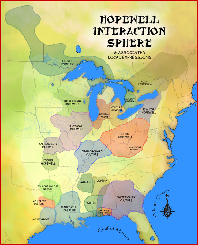
| 2010年2月7日 (日) 01:53 |  | 700 × 665(419 KB) | Heironymous Rowe | {{Information |Description={{en|1=A map showing the Hopewell Interaction Sphere and various local expressions of the Hopewell cultures, including the en:Laurel Complex, en:Saugeen Complex, en:Point Peninsula Complex, [[:en:Marksville cultur |
文件用途
以下页面使用本文件:
全域文件用途
以下其他wiki使用此文件:
- ar.wikipedia.org上的用途
- ca.wikipedia.org上的用途
- ckb.wikipedia.org上的用途
- de.wikipedia.org上的用途
- en.wikipedia.org上的用途
- Hopewell tradition
- Pinson Mounds
- Fort Ancient (Lebanon, Ohio)
- Mound Builders
- Black drink
- Woodland period
- Hopewell Culture National Historical Park
- Mounds State Park
- Icehouse Bottom
- Indian Mound Cemetery
- Great Hopewell Road
- Hopewell pottery
- Crooks Mound
- Crystal River Archaeological State Park
- Eastern Agricultural Complex
- Kolomoki Mounds
- Nanih Waiya
- Dickson Mounds
- Swift Creek culture
- Mound House (Greene County, Illinois)
- Yent Mound
- Kamp Mound Site
- Timeline of North American prehistory
- Indian Mounds Park (Saint Paul, Minnesota)
- Pierce Site
- Third Gulf Breeze
- Big Eddy Site
- Toolesboro Mound Group
- Rockwell Mound
- Naples Mound 8
- Trowbridge Archeological Site
- Moorehead Circle
- Benham Mound
- Perin Village Site
- Shawnee Lookout Archeological District
- Fortified Hill Works
- Williamson Mound Archeological District
- Serpent Mounds Park
- Albany Mounds State Historic Site
- Mound Cemetery (Marietta, Ohio)
- Old Stone Fort (Tennessee)
- Newark Earthworks
- Marksville Prehistoric Indian Site
- Leake Mounds
查看本文件的更多全域用途。
元数据
此文件中包含有额外的信息。这些信息可能是由数码相机或扫描仪在创建或数字化过程中所添加。
如果文件已从其原始状态修改,某些细节可能无法完全反映修改后的文件。
| 方位 | 标准 |
|---|---|
| 水平分辨率 | 72 dpi |
| 垂直分辨率 | 72 dpi |
| 使用软件 | Adobe Photoshop 7.0 |
| 文件修改日期时间 | 2010年2月8日 (一) 19:18 |
| 色彩空间 | sRGB |