File:Czechoslovakia01.png
維基百科,自由的 encyclopedia
預覽大小:800 × 340 像素。 其他解析度:320 × 136 像素 | 1,100 × 468 像素。
原始檔案 (1,100 × 468 像素,檔案大小:63 KB,MIME 類型:image/png)
摘要


|
本圖片是以PNG、GIF或JPEG格式上傳。然而,其中包含的資料或訊息,應該重新建立成可縮放向量圖形(SVG)檔案,以更有效率或更準確的方式儲存。如有可能,請上傳本圖片的SVG格式版本。在上傳之後,請修改維基各姊妹計畫中所有使用舊版圖片的條目(列在圖像連結章節中),替換為新版圖片,並在舊圖片的描述頁中加入{{Vector version available|新圖片名稱.svg}}模板,同時移除本模板。
|
The production, editing or release of this file was supported by the Community-Budget of Wikimedia Deutschland. To see other files made with the support of Wikimedia Deutschland, please see the category Supported by Wikimedia Deutschland. العربية ∙ বাংলা ∙ Deutsch ∙ English ∙ Esperanto ∙ français ∙ magyar ∙ Bahasa Indonesia ∙ italiano ∙ 日本語 ∙ македонски ∙ മലയാളം ∙ Bahasa Melayu ∙ Nederlands ∙ português ∙ русский ∙ slovenščina ∙ svenska ∙ українська ∙ தமிழ் ∙ +/−
|
說明
添加單行說明來描述出檔案所代表的內容
在此檔案描寫的項目
描繪內容
沒有維基數據項目的某些值
著作權狀態 繁體中文 (已轉換拼寫)
保有知識產權並由其所有者公開於公有領域 繁體中文 (已轉換拼寫)
著作權持有者釋出至公有領域 繁體中文 (已轉換拼寫)
2006
多媒體型式 繁體中文 (已轉換拼寫)
image/png
64,020 位元組
468 像素
1,100 像素
檔案歷史
點選日期/時間以檢視該時間的檔案版本。
| 日期/時間 | 縮圖 | 尺寸 | 用戶 | 備註 | |
|---|---|---|---|---|---|
| 目前 | 2022年7月12日 (二) 14:48 | | 1,100 × 468(63 KB) | Sebastian Wallroth | cropped |
| 2011年5月19日 (四) 10:54 |  | 1,128 × 513(63 KB) | PANONIAN | minor change, marked provincial capitals | |
| 2011年5月17日 (二) 09:53 |  | 1,128 × 513(62 KB) | PANONIAN | Reverted to version as of 10:38, 24 April 2011 - because this is map of Czechoslovakia and it was capital of Czechoslovakia | |
| 2011年5月17日 (二) 05:07 |  | 1,128 × 513(55 KB) | Millenium187 | Why was Prague underlined and Vienna, Brno, Bratislava and other capital cities were not? -- corrected | |
| 2011年4月24日 (日) 10:38 |  | 1,128 × 513(62 KB) | PANONIAN | few corrections | |
| 2011年4月23日 (六) 11:31 |  | 1,128 × 509(61 KB) | PANONIAN | improved version | |
| 2008年12月20日 (六) 20:58 |  | 1,100 × 497(78 KB) | Kirk979 | {{Information |Description= |Source= |Date= |Author= |Permission= |other_versions= }} | |
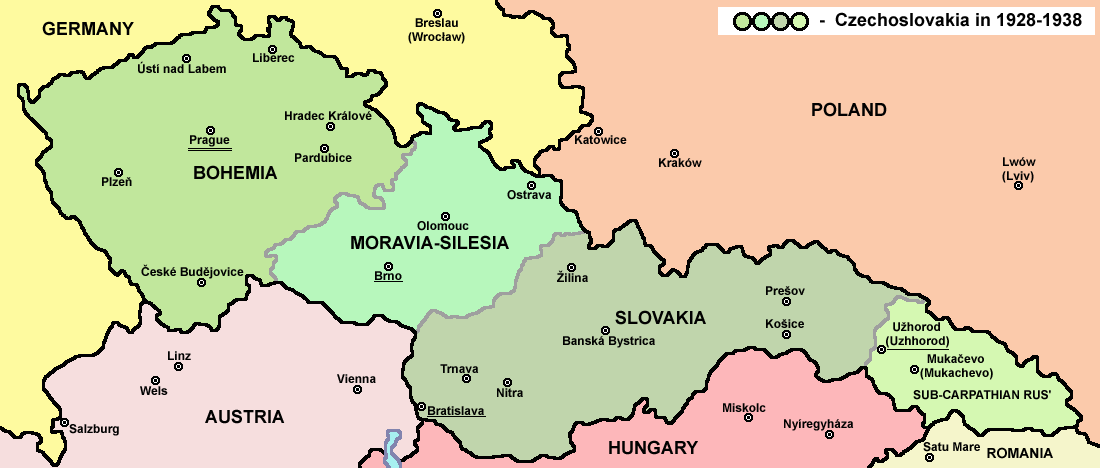
| 2006年12月28日 (四) 16:11 |  | 1,100 × 497(90 KB) | Electionworld | {{ew|en|PANONIAN}} Map of {{link|Czechoslovakia}} (self made) Note: The provinces shown on the map were introduced by Act No. 125/1927 Zb. and became effective in 1928. {{PD-self}} Category:Maps of Czechoslovakia Category:Maps of Czech history |
檔案用途
下列頁面有用到此檔案:
全域檔案使用狀況
以下其他 wiki 使用了這個檔案:
- af.wikipedia.org 的使用狀況
- als.wikipedia.org 的使用狀況
- ang.wikipedia.org 的使用狀況
- an.wikipedia.org 的使用狀況
- ar.wikipedia.org 的使用狀況
- arz.wikipedia.org 的使用狀況
- azb.wikipedia.org 的使用狀況
- az.wikipedia.org 的使用狀況
- bar.wikipedia.org 的使用狀況
- ba.wikipedia.org 的使用狀況
- bcl.wikipedia.org 的使用狀況
- be-tarask.wikipedia.org 的使用狀況
- be.wikipedia.org 的使用狀況
- bg.wikipedia.org 的使用狀況
- bn.wikipedia.org 的使用狀況
- br.wikipedia.org 的使用狀況
- ca.wikipedia.org 的使用狀況
- cs.wikipedia.org 的使用狀況
- cv.wikipedia.org 的使用狀況
- cy.wikipedia.org 的使用狀況
- de.wikipedia.org 的使用狀況
- diq.wikipedia.org 的使用狀況
- dsb.wikipedia.org 的使用狀況
- el.wikipedia.org 的使用狀況
- en.wikipedia.org 的使用狀況
檢視此檔案的更多全域使用狀況。
詮釋資料
此檔案中包含擴展的資訊。這些資訊可能是由數位相機或掃描器在建立時或數位化過程中所加入。
如果此檔案的來源檔案已被修改,一些資訊在修改後的檔案中將不能完全反映出來。
| 水平解析度 | 28.35 dpc |
|---|---|
| 垂直解析度 | 28.35 dpc |