File:Frankfurt_Am_Main-Altstadt-Zerstoerung-Luftbild_1944.jpg
維基百科,自由的 encyclopedia
預覽大小:745 × 599 像素。 其他解析度:299 × 240 像素 | 597 × 480 像素 | 955 × 768 像素 | 1,273 × 1,024 像素 | 2,546 × 2,048 像素 | 6,971 × 5,607 像素。
原始檔案 (6,971 × 5,607 像素,檔案大小:8.41 MB,MIME 類型:image/jpeg)
摘要
| 描述Frankfurt Am Main-Altstadt-Zerstoerung-Luftbild 1944.jpg |
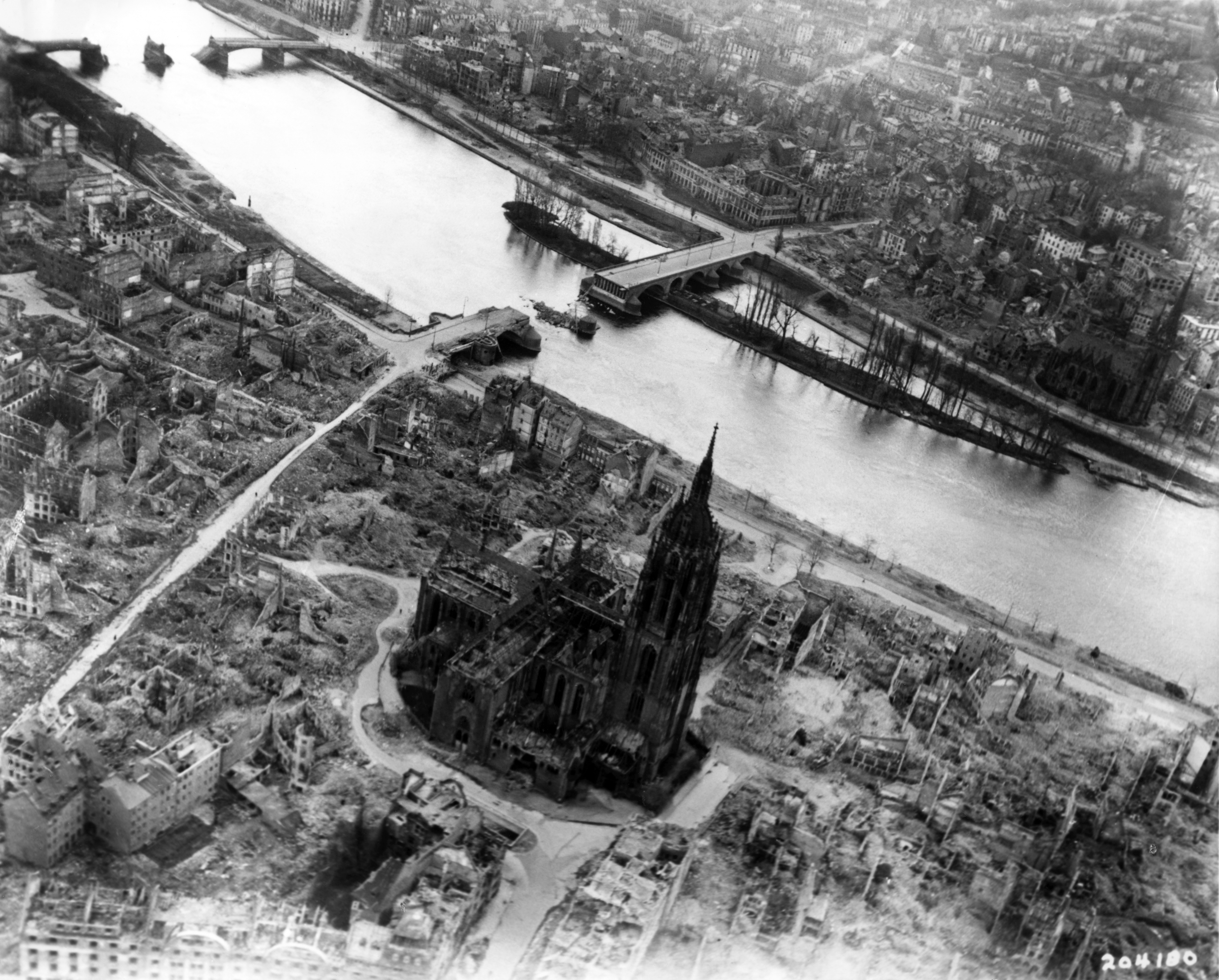
English: Frankfurt on the Main: Center of the Altstadt (Old Town) with the Cathedral, western part of the Fischerfeldviertel (Fisher Field Quarter) and the major part of Sachsenhausen with heavy damage and devastations of the allied bombings of World War II as seen from the air from about the Braubachstrasse (Braubach Street) to the south
Deutsch: Frankfurt am Main: Zentrum der Altstadt mit dem Dom, westlicher Teil des Fischerfeldviertels und der größte Teil von Sachsenhausen mit erheblichen Zerstörungen und Schäden der allierten Bombardements des Zweiten Weltkrieges, ungefähr von Höhe der Braubachstraße aus der Luft nach Süden gesehen
Français : Francfort sur le Main: Centre de la Vieille Ville avec vue sur la cathédrale, la partie Ouest du quartier Fischerfeld et de la majeure partie de Sachsenhausen. Les lourds dégats et destructions suite aux bombardements alliés de la Seconde Guerre Mondiale sont visibles sur cette vue aérienne de la rue Braubach vers le Sud. |
| 日期 | 攝於1945年三月31日 |
| 來源 |
Private collection institution QS:P195,Q768717 Mylius |
| 作者 | 未知Unknown author |
| 拍攝地點 | 50° 06′ 44.44″ 北, 8° 41′ 01.42″ 東 | 位於此地的本圖片與其他圖片: OpenStreetMap |
|---|
授權條款
| Public domainPublic domainfalsefalse |
|
العربية ∙ беларуская (тарашкевіца) ∙ català ∙ čeština ∙ Deutsch ∙ English ∙ español ∙ eesti ∙ فارسی ∙ suomi ∙ français ∙ italiano ∙ 日本語 ∙ 한국어 ∙ македонски ∙ മലയാളം ∙ မြန်မာဘာသာ ∙ norsk bokmål ∙ Plattdüütsch ∙ Nederlands ∙ polski ∙ português ∙ português do Brasil ∙ русский ∙ sicilianu ∙ slovenčina ∙ slovenščina ∙ српски / srpski ∙ svenska ∙ Türkçe ∙ українська ∙ Tiếng Việt ∙ 中文(简体) ∙ 中文(繁體) ∙ +/− |
 |
說明
添加單行說明來描述出檔案所代表的內容
在此檔案描寫的項目
描繪內容
31 3 1945
視角坐標 繁體中文 (已轉換拼寫)
50°6'44.438"N, 8°41'1.421"E
多媒體型式 繁體中文 (已轉換拼寫)
image/jpeg
檔案歷史
點選日期/時間以檢視該時間的檔案版本。
| 日期/時間 | 縮圖 | 尺寸 | 用戶 | 備註 | |
|---|---|---|---|---|---|
| 目前 | 2010年12月3日 (五) 22:55 | | 6,971 × 5,607(8.41 MB) | Mylius | Much better quality |
| 2006年3月8日 (三) 17:14 |  | 3,000 × 2,413(1.74 MB) | Mylius | Luftbild der US-Luftwaffe vom 31. März 1945 der Domumgebung. Deutlich zu erkennen ist die praktisch vollständige Vernichtung der reinen Fachwerkbauten v. a. süd- und nordöstlich des Doms - aber auch der reine Steinbau ''Haus Fürsteneck'' ist bis auf |
檔案用途
下列3個頁面有用到此檔案:
全域檔案使用狀況
以下其他 wiki 使用了這個檔案:
- ar.wikipedia.org 的使用狀況
- azb.wikipedia.org 的使用狀況
- be.wikipedia.org 的使用狀況
- cs.wikipedia.org 的使用狀況
- de.wikipedia.org 的使用狀況
- 22. März
- 20. Dezember
- Frankfurt-Altstadt
- Alte Brücke (Frankfurt am Main)
- Kaiserdom St. Bartholomäus
- Geschichte des Bistums Limburg
- Diskussion:Kühhornshof
- Trümmerverwertungsgesellschaft
- Luftangriffe auf Frankfurt am Main
- Wikipedia Diskussion:Hauptseite/Artikel des Tages/Archiv/Vorschläge/2014/Q1
- Wikipedia:Hauptseite/Archiv/18. März 2014
- el.wikipedia.org 的使用狀況
- en.wikipedia.org 的使用狀況
- Frankfurt
- Strategic bombing during World War II
- Altstadt (Frankfurt am Main)
- Frankfurt Cathedral
- Bombing of Frankfurt am Main in World War II
- Battle of Frankfurt
- Alte Brücke (Frankfurt)
- Wikipedia:Featured picture candidates/December-2020
- Wikipedia:Featured picture candidates/Bombing of Frankfurt am Main in World War II
- Post-war reconstruction of Frankfurt
- es.wikipedia.org 的使用狀況
- eu.wikipedia.org 的使用狀況
- fa.wikipedia.org 的使用狀況
- fi.wikipedia.org 的使用狀況
- fr.wikipedia.org 的使用狀況
- fy.wikipedia.org 的使用狀況
- he.wikipedia.org 的使用狀況
- hi.wikipedia.org 的使用狀況
- hr.wikipedia.org 的使用狀況
- hy.wikipedia.org 的使用狀況
- hyw.wikipedia.org 的使用狀況
- id.wikipedia.org 的使用狀況
- is.wikipedia.org 的使用狀況
- it.wikipedia.org 的使用狀況
- ja.wikipedia.org 的使用狀況
- kn.wikipedia.org 的使用狀況
- ko.wikipedia.org 的使用狀況
- mk.wikipedia.org 的使用狀況
- nl.wikipedia.org 的使用狀況
檢視此檔案的更多全域使用狀況。
詮釋資料
此檔案中包含擴展的資訊。這些資訊可能是由數位相機或掃描器在建立時或數位化過程中所加入。
如果此檔案的來源檔案已被修改,一些資訊在修改後的檔案中將不能完全反映出來。
| 寬度 | 6,971 px |
|---|---|
| 高度 | 5,607 px |
| 每像素位元 |
|
| 壓縮方式 | LZW |
| 像素合成 | RGB |
| 方位 | 標準 |
| 像素數量 | 3 |
| 水平解析度 | 600 dpi |
| 垂直解析度 | 600 dpi |
| 資料排列 | 矮胖格式 |
| 使用軟體 | Adobe Photoshop CS3 Windows |
| 檔案修改日期時間 | 2010年12月3日 (五) 23:52 |
| 色彩空間 | 顏色未校準 |
| 影像寬度 | 6,971 px |
| 影像高度 | 5,607 px |
| 數位化的日期時間 | 2010年12月4日 (六) 00:52 |
| 詮釋資料最後修改日期 | 2010年12月4日 (六) 00:52 |