File:MSH80_eruption_mount_st_helens_05-18-80-dramatic-edit.jpg
維基百科,自由的 encyclopedia
預覽大小:399 × 600 像素。 其他解析度:160 × 240 像素 | 319 × 480 像素 | 511 × 768 像素 | 681 × 1,024 像素 | 1,362 × 2,048 像素 | 2,994 × 4,500 像素。
原始檔案 (2,994 × 4,500 像素,檔案大小:2.14 MB,MIME 類型:image/jpeg)
| 描述MSH80 eruption mount st helens 05-18-80-dramatic-edit.jpg |
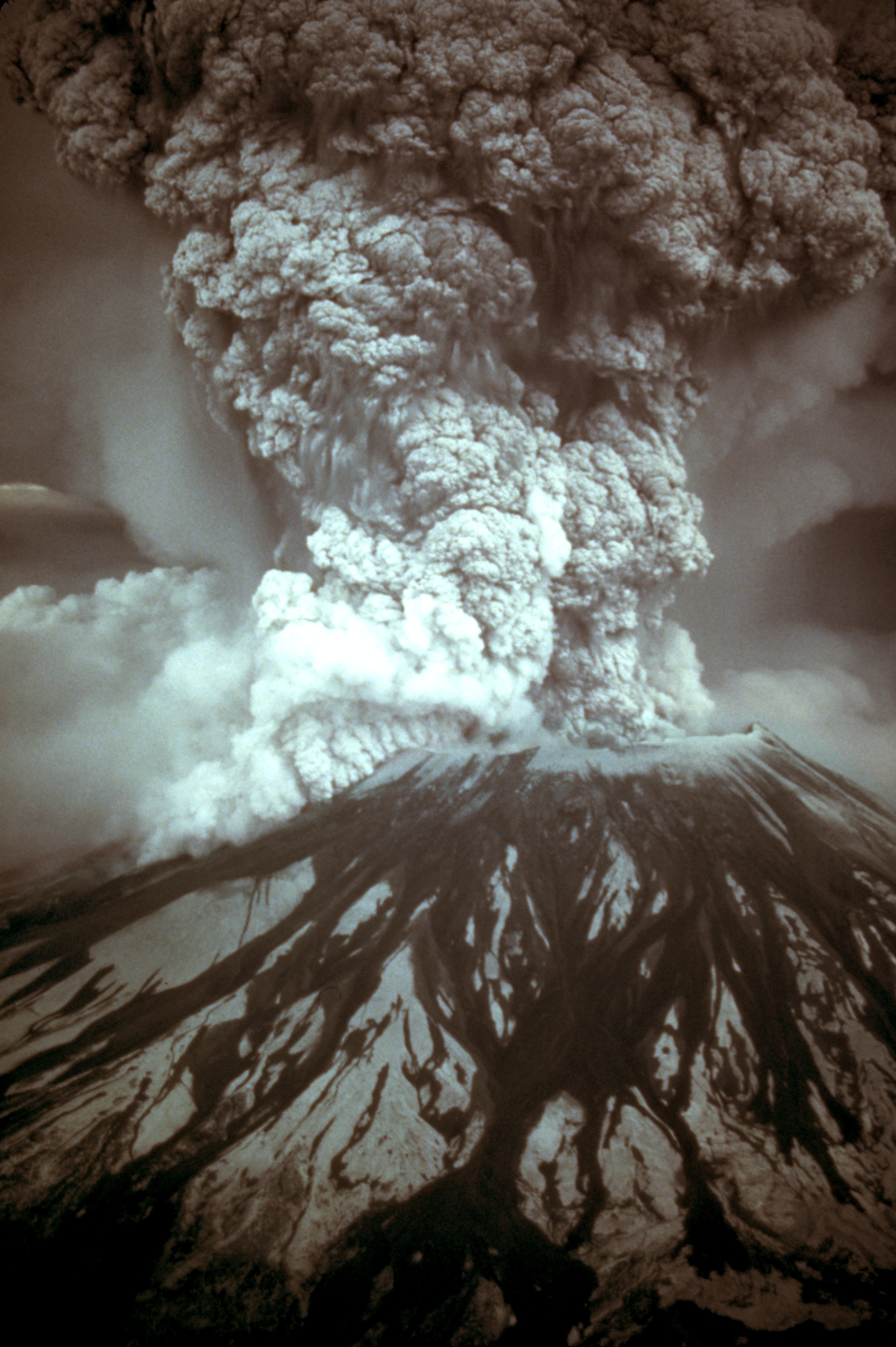
English: On May 18, 1980, at 8:32 a.m. Pacific Daylight Time, a magnitude 5.1 earthquake shook Mount St. Helens. The bulge and surrounding area slid away in a gigantic rockslide and debris avalanche, releasing pressure, and triggering a major pumice and ash eruption of the volcano. Thirteen-hundred feet (400 meters) of the peak collapsed or blew outwards. As a result, 24 square miles (62 square kilometers) of valley was filled by a debris avalanche, 250 square miles (650 square kilometers) of recreation, timber, and private lands were damaged by a lateral blast, and an estimated 200 million cubic yards (150 million cubic meters) of material was deposited directly by lahars (volcanic mudflows) into the river channels. Fifty-seven people were killed or are still missing.
USGS Photograph taken on May 18, 1980, by Austin Post.
Català: El 18 de maig, a les 8:32 a. m. Temps del Pacífic, un terratrèmol de una magnitud de 5,1 va fer trontollar la muntanya St. Helens. La protuberància l'àrea circumdant relliscà en una gegantina esllavissada de roques i un allau de rocam, alliberant la pressió, desencadenà una erupció de pedra tosca i cendra del volcà. 400 metres del puig van col·lapsar o van sortir volant. Com a resultat 62 quilometres quadrats de la vall van ser emplenats per la runa, 650 quilometres quadrats de llocs d'esbarjo, bosc, i finques privades van ser damnificades per una ràfega lateral, i una quantitat estimada en 150 milions de metres cúbics de material van ser dipositats per corrents de fang volcànic en els canals del riu. Cinquanta set persones van morir o han desaparegut (18 de Maig de 1980, Austin Post, USGS)
Español: Erupción del Monte Santa Helena el 18 de mayo de 1980. |
|||||||||||||
| 日期 | ||||||||||||||
| 來源 |
Huge tif converted to jpeg and caption from USGS Mount St. Helens, Washington May 18, 1980 Eruption Images |
|||||||||||||
| 作者 |
creator QS:P170,Q4823234 , scanned photograph by USGS, cleaned by and adjusted by carol |
|||||||||||||
| 授權許可 (重用此檔案) |
|
|||||||||||||
| 其他版本 |
 |
|||||||||||||
.jpg)
說明
添加單行說明來描述出檔案所代表的內容
Mount St. Helens eruption
Eruption Mount Saint Helens 18.05.1980
在此檔案描寫的項目
描繪內容
聖海倫斯火山 繁體中文 (已轉換拼寫)
1980年聖海倫斯火山爆發 繁體中文 (已轉換拼寫)
18 5 1980
檔案歷史
點選日期/時間以檢視該時間的檔案版本。
| 日期/時間 | 縮圖 | 尺寸 | 用戶 | 備註 | |
|---|---|---|---|---|---|
| 目前 | 2007年11月28日 (三) 15:17 | | 2,994 × 4,500(2.14 MB) | CarolSpears | |
| 2007年11月28日 (三) 11:41 |  | 2,994 × 4,500(1.92 MB) | CarolSpears | {{Information |Description={{en|On May 18, 1980, at 8:32 a.m. Pacific Daylight Time, a magnitude 5.1 earthquake shook Mount St. Helens. The bulge and surrounding area slid away in a gigantic rockslide and debris avalanche, releasing pressure, and triggeri |
檔案用途
下列8個頁面有用到此檔案:
全域檔案使用狀況
以下其他 wiki 使用了這個檔案:
- ar.wikipedia.org 的使用狀況
- ast.wikipedia.org 的使用狀況
- bg.wikipedia.org 的使用狀況
- ca.wikipedia.org 的使用狀況
- cs.wikipedia.org 的使用狀況
- de.wikipedia.org 的使用狀況
- el.wikipedia.org 的使用狀況
- en.wikipedia.org 的使用狀況
- 1980 eruption of Mount St. Helens
- May 1980
- Portal:Geology
- Talk:Mount St. Helens/Archive 2
- Template:Infobox eruption
- Template:Infobox eruption/doc
- Wikipedia:Featured picture candidates/Mount St. Helens eruption
- Wikipedia:Featured picture candidates/June-2013
- Timeline of Washington (state) history
- Template:Infobox eruption/sandbox
- en.wiktionary.org 的使用狀況
- es.wikipedia.org 的使用狀況
- fa.wikipedia.org 的使用狀況
- fi.wikipedia.org 的使用狀況
- fr.wikipedia.org 的使用狀況
- hr.wikipedia.org 的使用狀況
- hu.wikipedia.org 的使用狀況
- it.wikipedia.org 的使用狀況
- it.wikiquote.org 的使用狀況
- ja.wikipedia.org 的使用狀況
- km.wikipedia.org 的使用狀況
- kn.wikipedia.org 的使用狀況
- ko.wikipedia.org 的使用狀況
- mk.wikipedia.org 的使用狀況
- ms.wikipedia.org 的使用狀況
檢視此檔案的更多全域使用狀況。
詮釋資料
此檔案中包含擴展的資訊。這些資訊可能是由數位相機或掃描器在建立時或數位化過程中所加入。
如果此檔案的來源檔案已被修改,一些資訊在修改後的檔案中將不能完全反映出來。
| _error | 0 |
|---|