File:Usaf.e3sentry.750pix.jpg
維基百科,自由的 encyclopedia
預覽大小:800 × 515 像素。 其他解析度:320 × 206 像素 | 640 × 412 像素 | 1,024 × 659 像素 | 1,243 × 800 像素。
原始檔案 (1,243 × 800 像素,檔案大小:81 KB,MIME 類型:image/jpeg)
摘要
| 描述Usaf.e3sentry.750pix.jpg |
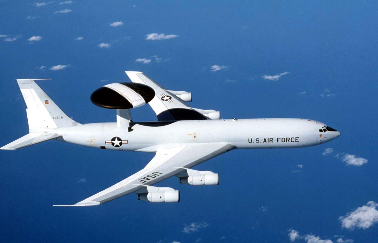
English: The E-3 Sentry is an airborne warning and control system aircraft that provides all-weather surveillance, command, control and communications needed by commanders of U.S. and NATO air defense forces. As proven in Desert Storm, it is the premier air battle command and control aircraft in the world today. The E-3 Sentry is a modified Boeing 707/320 commercial airframe with a rotating radar dome. The dome is 30 feet in diameter, six feet thick, and is held 11 feet above the fuselage by two struts. It contains a radar subsystem that permits surveillance fromthe Earth's surface up into the stratosphere, over land or water. The radar has a range of more than 200 miles for low-flying targets and farther for aerospace vehicles flying at medium to high altitudes. The radar combined with an identification friend or foe subsystem can look down to detect, identify and track enemy and friendly low-flying aircraft by eliminating ground clutter returns that confuse other radar systems. |
| 日期 | |
| 來源 | http://www.af.mil/shared/media/photodb/photos/021107-O-9999G-024.jpg |
| 作者 | U.S. Air Force photo |
授權條款
| Public domainPublic domainfalsefalse |
|
العربية ∙ беларуская (тарашкевіца) ∙ català ∙ čeština ∙ Deutsch ∙ English ∙ español ∙ eesti ∙ فارسی ∙ suomi ∙ français ∙ italiano ∙ 日本語 ∙ 한국어 ∙ македонски ∙ മലയാളം ∙ မြန်မာဘာသာ ∙ norsk bokmål ∙ Plattdüütsch ∙ Nederlands ∙ polski ∙ português ∙ português do Brasil ∙ русский ∙ sicilianu ∙ slovenčina ∙ slovenščina ∙ српски / srpski ∙ svenska ∙ Türkçe ∙ українська ∙ Tiếng Việt ∙ 中文(简体) ∙ 中文(繁體) ∙ +/− |
 |
說明
添加單行說明來描述出檔案所代表的內容
A USAF E-3 Sentry
26 11 2002
檔案歷史
點選日期/時間以檢視該時間的檔案版本。
| 日期/時間 | 縮圖 | 尺寸 | 用戶 | 備註 | |
|---|---|---|---|---|---|
| 目前 | 2007年11月3日 (六) 13:07 | | 1,243 × 800(81 KB) | Denniss | |
| 2005年12月16日 (五) 11:08 |  | 750 × 483(79 KB) | WonYong~commonswiki | U.S. Air Force photograph of the E-3 Sentry. By Gary Ell. {{PD-USGov-Military-Air Force}} [http://www.af.mil/photos] |
檔案用途
全域檔案使用狀況
以下其他 wiki 使用了這個檔案:
- ar.wikipedia.org 的使用狀況
- ast.wikipedia.org 的使用狀況
- bn.wikipedia.org 的使用狀況
- bs.wikipedia.org 的使用狀況
- ca.wikipedia.org 的使用狀況
- ckb.wikipedia.org 的使用狀況
- cs.wikipedia.org 的使用狀況
- de.wikipedia.org 的使用狀況
- el.wikipedia.org 的使用狀況
- en.wikipedia.org 的使用狀況
- Gunboat diplomacy
- Boeing Defense, Space & Security
- US–Saudi Arabia AWACS Sale
- User:Bosamar
- User:Sf46
- User:UBX/Military Aviator
- User:The Bushranger
- User:Magus732
- User:Sf46/Gunboat Diplomacy
- User:CnrFallon
- Help talk:Table/Archive 3
- User:Per Ardua Ad Astra
- User:Stars999
- List of AEW&C aircraft operators
- User:Kaiser Taylor
- User:Delta92
- User:Hhfjbaker
- User:Winkelvi
- Wikipedia:Userboxes/United States/Armed Forces
- User:Hilbert Halsay/sandbox
- User:Leobold111/userboxes
- User talk:WASR freak
- User:The Bushranger/Userbox1
檢視此檔案的更多全域使用狀況。
詮釋資料
此檔案中包含擴展的資訊。這些資訊可能是由數位相機或掃描器在建立時或數位化過程中所加入。
如果此檔案的來源檔案已被修改,一些資訊在修改後的檔案中將不能完全反映出來。
| 影像標題 | The E-3 Sentry is an airborne warning and control system (AWACS) aircraft that provides all-weather surveillance, command, control and communications needed by commanders of U.S. and NATO air defense forces. As proven in Desert Storm, it is the premier air battle command and control aircraft in the world today. The E-3 Sentry is a modified Boeing 707/320 commercial airframe with a rotating radar dome. The dome is 30 feet (9.1 meters) in diameter, six feet (1.8 meters) thick, and is held 11 feet (3.3 meters) above the fuselage by two struts. It contains a radar subsystem that permits surveillance fromthe Earth's surface up into the stratosphere, over land or water. The radar has a range of more than 200 miles (320 kilometers) for low-flying targets and farther for aerospace vehicles flying at medium to high altitudes. The radar combined with an identification friend or foe subsystem can look down to detect, identify and track enemy and friendly low-flying aircraft by eliminating ground clutter returns that confuse other radar systems. (U.S. Air Force photo) |
|---|---|
| 方位 | 標準 |
| 水平解析度 | 200 dpi |
| 垂直解析度 | 200 dpi |
| 使用軟體 | Adobe Photoshop 7.0 |
| 檔案修改日期時間 | 2002年11月26日 (二) 09:33 |
| 色彩空間 | 顏色未校準 |