File:2019-09-25_Kairatu,_Indonesia_M6.5_earthquake_shakemap_(USGS).jpg
维基百科,自由的 encyclopedia
本预览的尺寸:463 × 600像素。 其他分辨率:185 × 240像素 | 370 × 480像素 | 822 × 1,065像素。
原始文件 (822 × 1,065像素,文件大小:206 KB,MIME类型:image/jpeg)
摘要
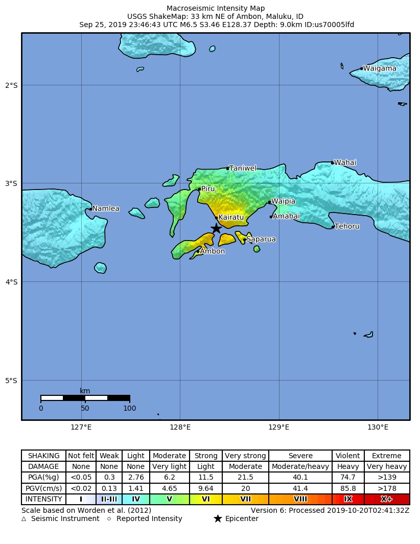
| 描述2019-09-25 Kairatu, Indonesia M6.5 earthquake shakemap (USGS).jpg |
English: Shakemap from USGS for the magnitude 6.5, maximum intensity 7.166 earthquake with tsunami near en:Usgs Neic Shakemap (10km S of en:Kairatu, Indonesia), 18.2 km depth. |
| 日期 | |
| 来源 | https://earthquake.usgs.gov/earthquakes/eventpage/us70005lfd |
| 作者 | 美国地质调查局 |
许可协议
| Public domainPublic domainfalsefalse |
|
Bahasa Indonesia ∙ català ∙ čeština ∙ Deutsch ∙ eesti ∙ English ∙ español ∙ français ∙ galego ∙ italiano ∙ Nederlands ∙ português ∙ polski ∙ sicilianu ∙ suomi ∙ Tiếng Việt ∙ Türkçe ∙ български ∙ македонски ∙ русский ∙ മലയാളം ∙ 한국어 ∙ 日本語 ∙ 中文 ∙ 中文(简体) ∙ 中文(繁體) ∙ العربية ∙ فارسی ∙ +/− |
说明
添加一行文字以描述该文件所表现的内容
සිංහල
Myanmar
此文件中描述的项目
描绘内容
25 9 2019
媒体类型 简体中文(已转写)
image/jpeg
数据大小 简体中文(已转写)
211,240 字节
1,065 像素
822 像素
文件历史
点击某个日期/时间查看对应时刻的文件。
| 日期/时间 | 缩略图 | 大小 | 用户 | 备注 | |
|---|---|---|---|---|---|
| 当前 | 2019年10月20日 (日) 04:03 | | 822 × 1,065(206 KB) | Cewbot | Import USGS updated earthquake map, shakemap id: urn:usgs-product:us:shakemap:us70005lfd:1571539345527 (2019-10-20T02:42:25.527Z) |
| 2019年9月29日 (日) 02:04 |  | 822 × 1,062(209 KB) | Cewbot | Import USGS updated earthquake map, shakemap id: urn:usgs-product:us:shakemap:us70005lfd:1569541734683 (2019-09-26T23:48:54.683Z) | |
| 2019年9月26日 (四) 02:03 |  | 822 × 1,062(208 KB) | Cewbot | Import USGS earthquake map, shakemap id: urn:usgs-product:us:shakemap:us70005lfd:1569462525513 (2019-09-26T01:48:45.513Z) |
文件用途
以下页面使用本文件:
全域文件用途
以下其他wiki使用此文件:
- de.wikipedia.org上的用途
- en.wikipedia.org上的用途
- fa.wikipedia.org上的用途
- id.wikipedia.org上的用途
- nl.wikipedia.org上的用途
- pl.wikipedia.org上的用途
- ru.wikipedia.org上的用途
.jpg)