File:Midland_Main_Line_Map_en.png
维基百科,自由的 encyclopedia
本预览的尺寸:543 × 599像素。 其他分辨率:217 × 240像素 | 435 × 480像素 | 696 × 768像素 | 928 × 1,024像素 | 2,087 × 2,304像素。
原始文件 (2,087 × 2,304像素,文件大小:1.9 MB,MIME类型:image/png)
摘要
| 描述Midland Main Line Map en.png |
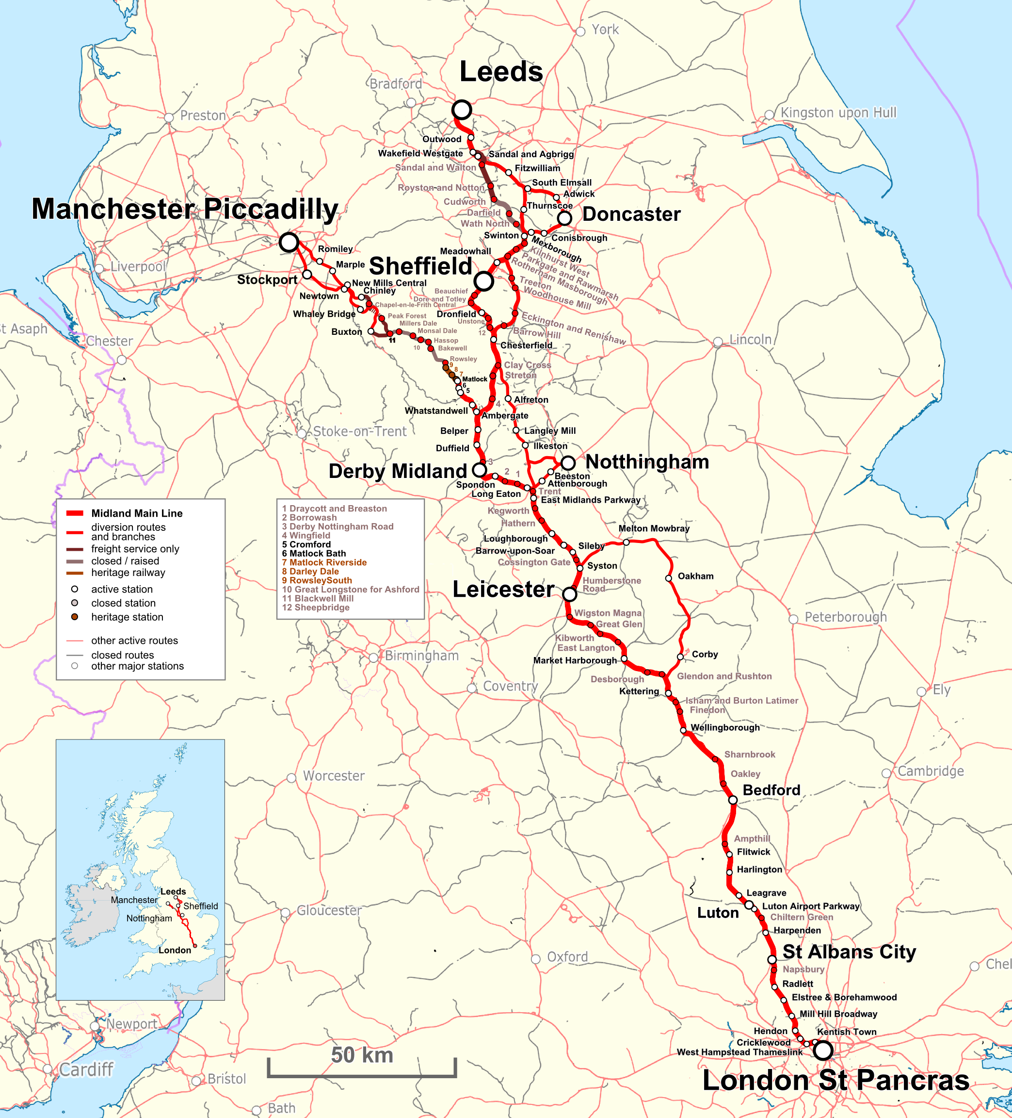
English: Map of the Midland Main Line in UK. Index in English Deutsch: Karte der Midland Main Line in UK. Legende Englisch |
| 日期 | |
| 来源 |
Map was created by using
|
| 作者 |
|
| 授权 (二次使用本文件) |
Map data (c) OpenStreetMap (and) contributors, CC-BY-SA |
| 其他版本 |
same file with German index:  |
许可协议
我,本作品著作权人,特此采用以下许可协议发表本作品:
本文件采用知识共享署名 3.0 未本地化版本许可协议授权。
署名: Peter Christener
- 您可以自由地:
- 共享 – 复制、发行并传播本作品
- 修改 – 改编作品
- 惟须遵守下列条件:
- 署名 – 您必须对作品进行署名,提供授权条款的链接,并说明是否对原始内容进行了更改。您可以用任何合理的方式来署名,但不得以任何方式表明许可人认可您或您的使用。
| This work is licensed under the Open Database License (summary).Open Database LicenseODbLhttp://opendatacommons.org/licenses/odbl/1.0/true |
说明
添加一行文字以描述该文件所表现的内容
此文件中描述的项目
描绘内容
知识共享署名3.0未本地化版本 简体中文(已转写)
28 5 2017
文件历史
点击某个日期/时间查看对应时刻的文件。
| 日期/时间 | 缩略图 | 大小 | 用户 | 备注 | |
|---|---|---|---|---|---|
| 当前 | 2017年5月28日 (日) 13:39 | | 2,087 × 2,304(1.9 MB) | Pechristener | {{Information |Description={{en|Map of the {{w|Midland Main Line}} in UK. Index in English}}{{de|Karte der {{w|Midland Main Line||de}} in UK. Legende Englisch}} |Source=Map was created by using * [http://www.openstreetmap.org/ Open Street Map] Data *... |
文件用途
以下页面使用本文件:
全域文件用途
以下其他wiki使用此文件:
- de.wikipedia.org上的用途
- en.wikipedia.org上的用途
- fr.wikipedia.org上的用途
- ja.wikipedia.org上的用途
- lt.wikipedia.org上的用途
- pl.wikipedia.org上的用途
- yi.wikipedia.org上的用途
元数据
此文件中包含有扩展的信息。这些信息可能是由数码相机或扫描仪在创建或数字化过程中所添加。
如果此文件的源文件已经被修改,一些信息在修改后的文件中将不能完全反映出来。
| 水平分辨率 | 27.56 dpc |
|---|---|
| 垂直分辨率 | 27.56 dpc |
| 使用软件 |