File:Map_Bih_entities.png
From Wikipedia, the free encyclopedia
預覽大細:633 × 599 像素。 第啲解像度:254 × 240 像素|507 × 480 像素|811 × 768 像素|1,103 × 1,044 像素。
原本檔案 (1,103 × 1,044 像素,檔案大細:67 KB ,MIME類型:image/png)
摘要
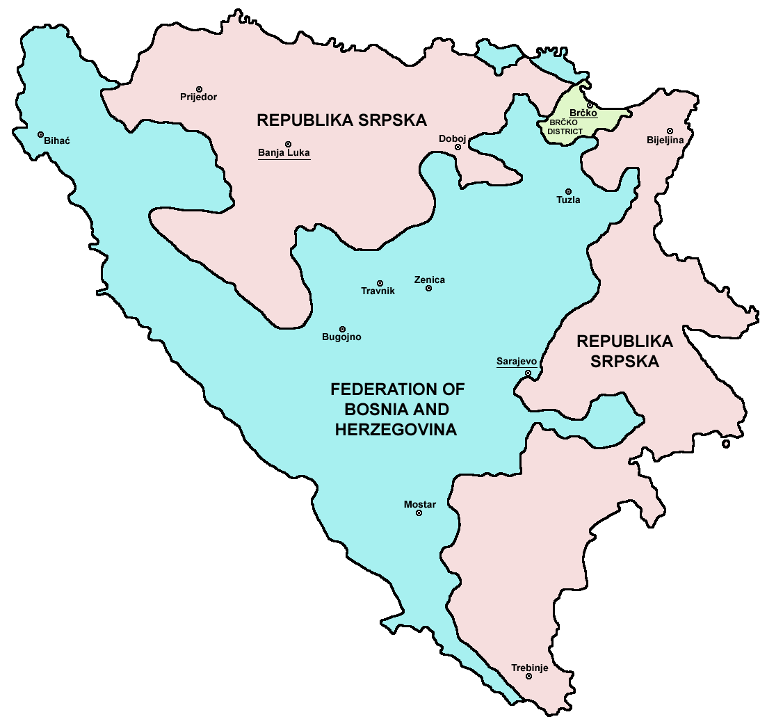
| 描述Map Bih entities.png |
Srpskohrvatski / српскохрватски: Federacija Bosne i Hercegovine, Republika Srpska i Distrikt Brčko / Федерација Босне и Херцеговине, Република Српска и Дистрикт Брчко. |
| 日期 | |
| 來源 | en:Image:M_bih03.png |
| 作者 | User:PANONIAN |
| Other versions |
[改]
|


.png)


References
- Slobodan Radovanović, Geografski atlas, Magic Map, Smederevska Palanka, 2001.
- Geografski atlas, Intersistem kartografija, Beograd, 2004.
- http://www.mapsofworld.com/bosnia/maps/bosnia-herzegovina-map.jpg
- http://www.slobodanjovanovic.org/wp-content/uploads/2009/12/bosna-kantoni1.jpg
- http://www.thomasgraz.net/glass/map-BIH.gif
- http://aceproject.org/ero-en/regions/europe/BA/doc1.jpg/image
- United States Department of State
- http://www.visitbosnia.org/bih/images/stories/o_bih/drzavno_uredjenje/entiteti.jpg[dead link]
- http://www.conflictgeographies.org/uploads/2/6/1/8/2618869/8958714.jpg?490 archive copy at the Wayback Machine
- http://vozi.org/images/stories/broj%20registrovanih%20vozila%202010.godina.png
- http://www.ohr.int/ohr-offices/brcko/images/map-brcko-district.jpg
- http://www.ohr.int/ohr-offices/brcko/images/mapa%20BD.JPG
- http://www.conflictgeographies.org/uploads/2/6/1/8/2618869/388168.jpg?490 archive copy at the Wayback Machine
- http://world-gazetteer.com/ archive copy at the Wayback Machine
協議
| Public domainPublic domainfalsefalse |
| I, the copyright holder of this work, release this work into the public domain. This applies worldwide. In some countries this may not be legally possible; if so: I grant anyone the right to use this work for any purpose, without any conditions, unless such conditions are required by law. |

|
This map image could be recreated using vector graphics as an SVG file. This has several advantages; see Commons:Media for cleanup for more information. If an SVG form of this image is already available, please upload it. After uploading an SVG, replace this template with {{vector version available|new image name.svg}}.
|
Captions
Add a one-line explanation of what this file represents
Items portrayed in this file
圖中顯示嘅係
28 1 2006
image/png
檔案歷史
撳個日期/時間去睇響嗰個時間出現過嘅檔案。
| 日期/時間 | 縮圖 | 尺寸 | 用戶 | 註解 | |
|---|---|---|---|---|---|
| 現時 | 2010年7月6號 (二) 21:38 | | 1,103 × 1,044(67 KB) | PANONIAN | Reverted to version as of 23:51, 12 March 2010 - I do not agree that these are better colours. it is subjective opinion and it is bad idea that every user should upload new file version because he have different opinion about "better" colours |
| 2010年7月6號 (二) 12:26 |  | 1,103 × 1,044(58 KB) | Mostarac | better colors | |
| 2010年7月6號 (二) 12:25 |  | 1,103 × 1,044(58 KB) | Mostarac | better colors and cities. | |
| 2010年3月12號 (五) 23:51 |  | 1,103 × 1,044(67 KB) | Dungodung | Well, I beg to differ. This one shows cities and is of better quality | |
| 2010年3月9號 (二) 11:55 |  | 700 × 615(172 KB) | Mostarac | revert, bolje boje! | |
| 2009年12月20號 (日) 21:10 |  | 1,103 × 1,044(67 KB) | PANONIAN | improved version | |
| 2007年7月16號 (一) 08:05 |  | 700 × 615(13 KB) | Nihad Hamzic | This image was once a JPEG, the author had simply directly converted it to JPEG. I have grealty optimised its size by removing JPEG artifacts, and reducing color domain. | |
| 2006年1月28號 (六) 22:42 |  | 700 × 615(172 KB) | (:Julien:) | Map of the 2 entities of the BiH and the Brčko district, author: en:User:PANONIAN, source: en:Image:M_bih03.png, PANONIAN is the creator and released it under PD. Category:Bosnia and Herzegovina |
檔案用途
以下嘅1版用到呢個檔:
全域檔案使用情況
下面嘅維基都用緊呢個檔案:
- af.wikipedia.org嘅使用情況
- ami.wikipedia.org嘅使用情況
- am.wikipedia.org嘅使用情況
- arc.wikipedia.org嘅使用情況
- ar.wikipedia.org嘅使用情況
- arz.wikipedia.org嘅使用情況
- ast.wikipedia.org嘅使用情況
- az.wikipedia.org嘅使用情況
- bat-smg.wikipedia.org嘅使用情況
- be-tarask.wikipedia.org嘅使用情況
- bi.wikipedia.org嘅使用情況
- bjn.wikipedia.org嘅使用情況
- bn.wikipedia.org嘅使用情況
- bo.wikipedia.org嘅使用情況
- bpy.wikipedia.org嘅使用情況
- br.wikipedia.org嘅使用情況
- bs.wikipedia.org嘅使用情況
- ca.wikipedia.org嘅使用情況
- ceb.wikipedia.org嘅使用情況
- ce.wikipedia.org嘅使用情況
- ckb.wikipedia.org嘅使用情況
- co.wikipedia.org嘅使用情況
- crh.wikipedia.org嘅使用情況
- csb.wikipedia.org嘅使用情況
- cs.wikipedia.org嘅使用情況
- cs.wikinews.org嘅使用情況
- cv.wikipedia.org嘅使用情況
- cy.wikipedia.org嘅使用情況
- da.wikipedia.org嘅使用情況
- de.wikipedia.org嘅使用情況
- diq.wikipedia.org嘅使用情況
- dv.wikipedia.org嘅使用情況
- ee.wikipedia.org嘅使用情況
- el.wikipedia.org嘅使用情況
- en.wikipedia.org嘅使用情況
- Bosnia and Herzegovina
- History of Bosnia and Herzegovina
- Multinational state
- Republika Srpska (1992–1995)
- Inter-Entity Boundary Line
- Talk:Inter-Entity Boundary Line
- Portal:Bosnia and Herzegovina
- User:Jonny-mt/Gallery of current first-level administrative country subdivisions maps
- Politics of country subdivisions
- Talk:Federation of Bosnia and Herzegovina/Archive 1
- en.wikivoyage.org嘅使用情況
睇呢個檔案嘅更多全域使用情況。