File:China_administrative.gif
維基百科,自由的 encyclopedia
原始文件 (857 × 699像素,文件大小:52 KB,MIME类型:image/gif)

|
此locator map图片可使用矢量图形重新创建为SVG文件。这具有很多好处;更多信息请参见共享资源:待清理媒体。如果存在此图片的SVG格式,请将其上传,然后将此模板替换为
{{vector version available|新图片名称}}。
建议您将SVG命名为“China administrative.svg”,这样在使用Vector version available(或Vva)模板时就不需要填写新图片名称参数。 |
摘要
| 描述China administrative.gif | This is a GIF copy of the PNG image originally created by Ran. When scaled for use in wikipedia templates and articles it uses a lot less kilobytes than the scaled PNG image. The image quality is the same since there are only 64 unique colors in the image. GIF can accommodate up to 256 unique colors. |
| 日期 | |
| 来源 | Image:China administrative.png |
| 作者 | User:Ran image converted to GIF image by user:Timeshifter |
| 其他版本 | 此文件衍生的作品: Pokrajine NR Kine.png |
Info below is copied from Image:China administrative.png.
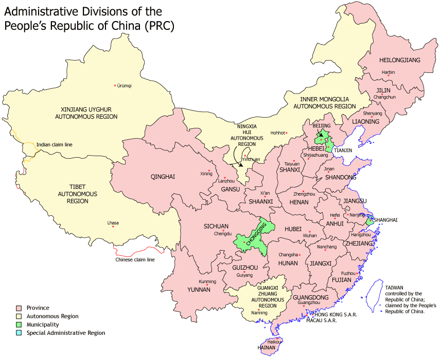
Administrative divisions of China. Made by Ran.
Features:
- Latest borders as of 2004. Qinghai-Gansu border readjustments are reflected; Sino-Russian agreement on the Amur-Ussuri delta is also (approximately) reflected.
- Disputed areas are given as neutral a treatment as possible.
The map was made based on a large-scale map of China made by woodhome and hunry of the XZQH forums.
Looking for translators!: If you want to translate the map into another language, here's a blank map that you can work with:
Alternatively, you can message me with the translated texts, and I will incorporate your translations for you and credit you for your work. (You don't have to translate the place names; I'll attempt to get them, as far as possible, from the Wikipedia in that language.) Same goes for any additions or corrections you'd like to make.
Translations have already been done for Spanish, German, Chinese (Simplified/Traditional), Japanese, French, Russian, Macedonian, Vietnamese, and Hebrew.
See also: en:Wikipedia:WikiProject Chinese provinces/Locator maps
许可协议

|
已授权您依据自由软件基金会发行的无固定段落及封面封底文字(Invariant Sections, Front-Cover Texts, and Back-Cover Texts)的GNU自由文件许可协议1.2版或任意后续版本的条款,复制、传播和/或修改本文件。该协议的副本请见“GNU Free Documentation License”。http://www.gnu.org/copyleft/fdl.htmlGFDLGNU Free Documentation Licensetruetrue |
| 本文件采用知识共享署名-相同方式共享 3.0 未本地化版本许可协议授权。 | ||
| ||
| 本许可协议标签作为GFDL许可协议更新的组成部分被添加至本文件。http://creativecommons.org/licenses/by-sa/3.0/CC BY-SA 3.0Creative Commons Attribution-Share Alike 3.0truetrue |
说明
此文件中描述的项目
描繪內容
5 10 2007
image/gif
53,501 字节
699 像素
857 像素
文件历史
点击某个日期/时间查看对应时刻的文件。
| 日期/时间 | 缩略图 | 大小 | 用户 | 备注 | |
|---|---|---|---|---|---|
| 当前 | 2008年10月5日 (日) 21:21 | | 857 × 699(52 KB) | Ran | |
| 2008年10月5日 (日) 21:16 |  | 1,339 × 1,092(124 KB) | Ran | ||
| 2007年10月5日 (五) 13:43 |  | 857 × 699(95 KB) | Timeshifter | {{Information |Description= This is a GIF copy of the PNG image originally created by Ran. When scaled for use in wikipedia templates and articles it uses a lot less kilobytes than the scaled PNG image. The image quality is the same since |
文件用途
没有页面链接到本图像。
全域文件用途
以下其他wiki使用此文件:
- ace.wikipedia.org上的用途
- af.wikipedia.org上的用途
- arz.wikipedia.org上的用途
- be.wikipedia.org上的用途
- bs.wikipedia.org上的用途
- en.wikipedia.org上的用途
- fa.wikipedia.org上的用途
- fa.wikivoyage.org上的用途
- fr.wikinews.org上的用途
- hr.wikipedia.org上的用途
- id.wikipedia.org上的用途
- incubator.wikimedia.org上的用途
- ja.wikipedia.org上的用途
- lv.wikipedia.org上的用途
- mr.wikipedia.org上的用途
- ms.wikipedia.org上的用途
- mzn.wikipedia.org上的用途
- nl.wikipedia.org上的用途
- pnb.wikipedia.org上的用途
- sd.wikipedia.org上的用途
- sh.wikipedia.org上的用途
- simple.wikipedia.org上的用途
- skr.wikipedia.org上的用途
查看此文件的更多全域用途。