File:XXth_Century_Citizen's_Atlas_map_of_Central_Asia.png
From Wikipedia, the free encyclopedia
Size of this preview: 800 × 566 pixels. Other resolutions: 320 × 227 pixels | 640 × 453 pixels | 1,024 × 725 pixels | 1,280 × 906 pixels | 2,548 × 1,804 pixels.
Original file (2,548 × 1,804 pixels, file size: 7.49 MB, MIME type: image/png)
| This is a file from the Wikimedia Commons. Information from its description page there is shown below. Commons is a freely licensed media file repository. You can help. |
| DescriptionXXth Century Citizen's Atlas map of Central Asia.png | |
| Date | |
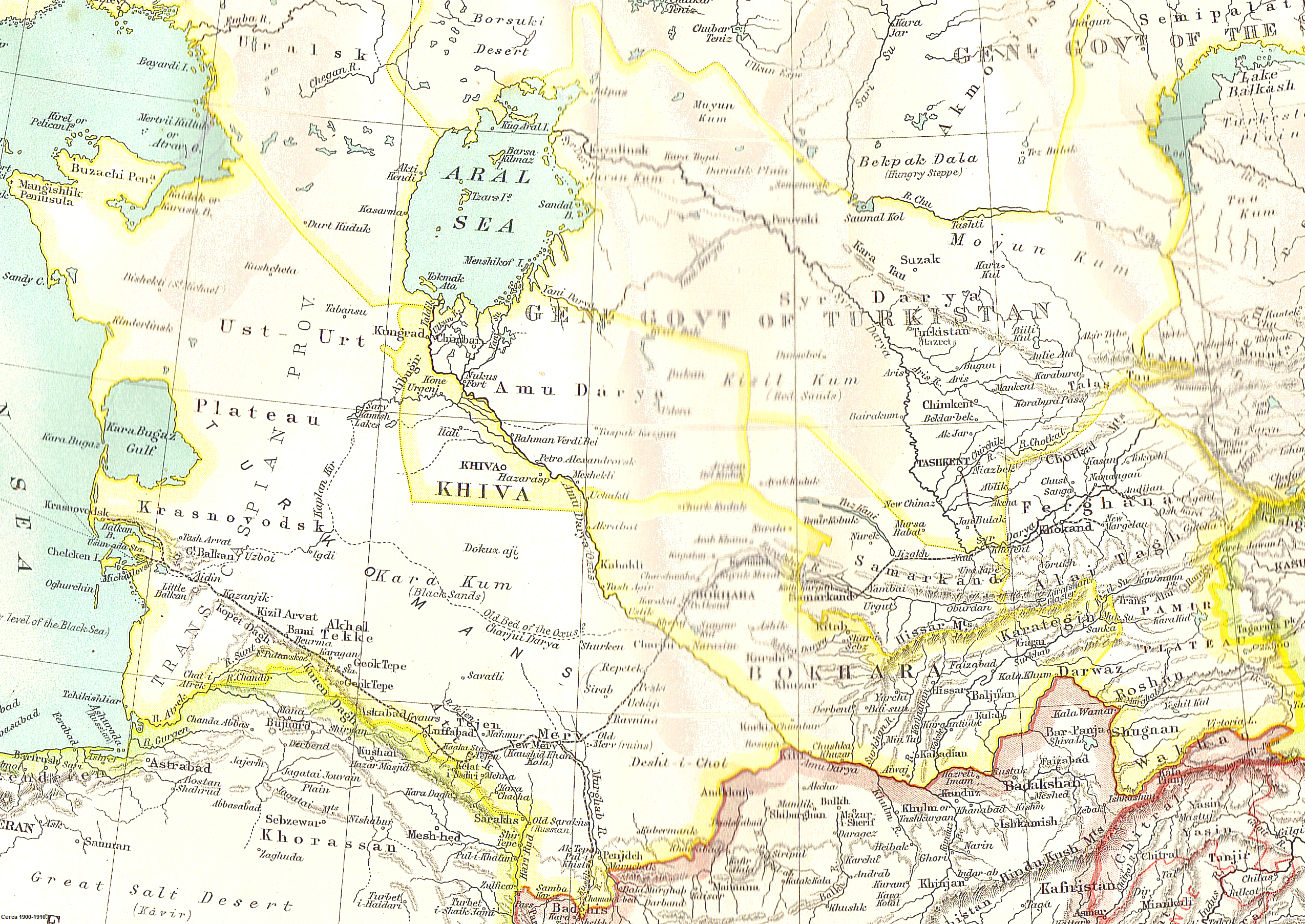
| Source | Scanned from John Bartholomew's XXth Century Citizen's Atlas (1903) |
| Author | Uncertain: either John George Bartholomew or an unknown employee |
| Permission (Reusing this file) |
If this were produced by Bartholomew himself, it is {{PD-UK-known}}, because Bartholomew died in 1920. If it were produced by an anonymous employee, it is {{PD-UK-unknown}}, because it is an anonymous artistic work other than a photograph, which was made available to the public before 1 January 1940. Either way, it is public domain in the United Kingdom, the country of origin. Published before 1923, it is also public domain in the United States. |
| Public domainPublic domainfalsefalse |
This media file is in the public domain in the United States. This applies to U.S. works where the copyright has expired, often because its first publication occurred prior to January 1, 1929, and if not then due to lack of notice or renewal. See this page for further explanation.
|
 | |
 |
This image might not be in the public domain outside of the United States; this especially applies in the countries and areas that do not apply the rule of the shorter term for US works, such as Canada, Mainland China (not Hong Kong or Macao), Germany, Mexico, and Switzerland. The creator and year of publication are essential information and must be provided. See Wikipedia:Public domain and Wikipedia:Copyrights for more details.
|
Captions
Map of Central Asia in 1903, including Russian Empire territory in Central Asia.
Items portrayed in this file
depicts
1903
File history
Click on a date/time to view the file as it appeared at that time.
| Date/Time | Thumbnail | Dimensions | User | Comment | |
|---|---|---|---|---|---|
| current | 12:18, 6 May 2010 | | 2,548 × 1,804 (7.49 MB) | Nyttend | {{Information |Description = A map of Central Asia |Source = Scanned from [http://catalogue.nla.gov.au/Record/2532586 John Bartholomew's ''XXth Century Citizen's Atlas'' (1903)] |Date = 1903 |Author = Uncertain: either John George Bartholomew or an un |
File usage
The following pages on the English Wikipedia use this file (pages on other projects are not listed):
- Arys (river)
- Foreign policy of the Russian Empire
- Khanate of Khiva
- Khanate of Kokand
- Khwarazm
- Russian Turkestan
- Soviet Central Asia
- Uzboy
- User:Falcaorib
- User:John Q. A. Geadon
- User talk:Its snowing in East Asia/Archive pictures 0
- User talk:Its snowing in East Asia/Archive pictures 1
- User talk:Its snowing in East Asia/Archive pictures 2
- User talk:Snow storm in Eastern Asia/Archive pictures 2
Global file usage
The following other wikis use this file:
- Usage on ar.wikipedia.org
- Usage on azb.wikipedia.org
- Usage on bg.wikipedia.org
- Usage on bn.wikipedia.org
- Usage on da.wikipedia.org
- Usage on de.wikipedia.org
- Usage on el.wikipedia.org
- Usage on es.wikipedia.org
- Usage on et.wikipedia.org
- Usage on fa.wikipedia.org
- Usage on fi.wikipedia.org
- Usage on he.wikipedia.org
- Usage on it.wikipedia.org
- Usage on ka.wikipedia.org
- Usage on kk.wikipedia.org
- Usage on ko.wikipedia.org
- Usage on lv.wikipedia.org
- Usage on nl.wikipedia.org
- Usage on no.wikipedia.org
- Usage on pa.wikipedia.org
- Usage on pl.wikipedia.org
- Usage on pt.wikipedia.org
- Usage on ro.wikipedia.org
- Usage on th.wikipedia.org
- Usage on tr.wikipedia.org
- Usage on vi.wikipedia.org
- Usage on zh.wikipedia.org