File:Rzeczpospolita_1600.png
From Wikipedia, the free encyclopedia
Kích thước hình xem trước: 765×600 điểm ảnh. Độ phân giải khác: 306×240 điểm ảnh | 612×480 điểm ảnh | 980×768 điểm ảnh | 1.280×1.004 điểm ảnh | 2.000×1.568 điểm ảnh.
Tập tin gốc (2.000×1.568 điểm ảnh, kích thước tập tin: 329 kB, kiểu MIME: image/png)
Tập tin này từ Wikimedia Commons. Trang miêu tả nó ở đấy được sao chép dưới đây. Commons là kho lưu trữ tập tin phương tiện có giấy phép tự do. Bạn có thể tham gia. |

|
Hình ảnh thuộc thể loại "historical map" cần được vẽ lại bằng đồ họa vector theo định dạng tập tin SVG. Để biết ưu điểm của định dạng này, hãy đọc Commons:Media for cleanup. Nếu tập tin này đã có SVG, xin hãy tải lên đây rồi thay bản mẫu này bằng {{vector version available|tên hình mới.svg}}.
|
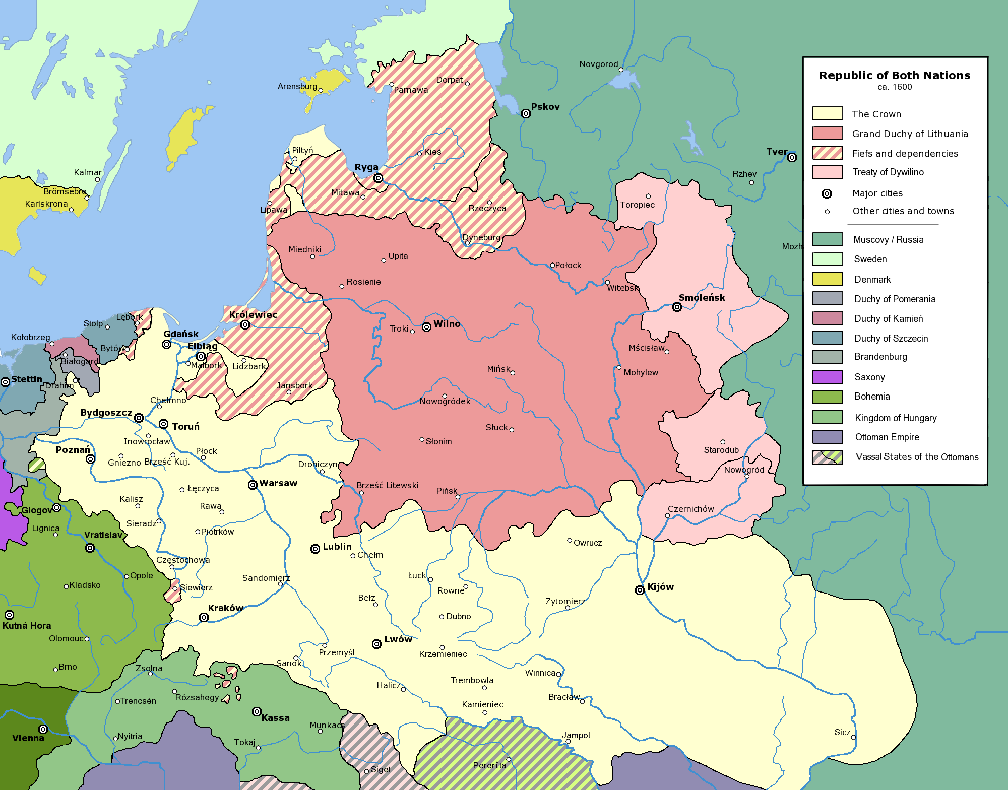
Commonwealth of Both Nations at the peak of its strength, after the Treaty of Dywilino.
The following is a list of maps created by Halibutt and uploaded to commons, as well as their present and projected derivatives.
| Parent Image | Image | Description | |||||||||||
|---|---|---|---|---|---|---|---|---|---|---|---|---|---|
| Maps by Halibutt | |||||||||||||
| Image:Rzeczpospolita.png | Image:Rzeczpospolita.png | The Republic in 17th and 18th century | |||||||||||
| Image:Rzeczpospolita 1600.png | The Republic after the Treaty of Dywilino | ||||||||||||
| Image:Rzeczpospolita voivodships.png | Voivodships of The Republic | ||||||||||||
| Image:Rzeczpospolita_Potop.png | The Republic during The Deluge and Chmielnicki Uprising, with major battles of the era marked | ||||||||||||
| Magnates and their lands and domains | |||||||||||||
| 1st • 2nd • 3rd | Partitions of Poland | ||||||||||||
| War of the constitution | |||||||||||||
| Image:Rzeczpospolita.xcf | SOURCE FILE - GIMP format | ||||||||||||
| Image:Poland 1939.png | Image:Poland 1939.png | Poland in 1939 | |||||||||||
| Image:Dywizje wrzesien 1.png | Order of Battle on September 1st, during the Polish Defence War of 1939 | ||||||||||||
| Image:Poland 1939.xcf | SOURCE FILE - GIMP format | ||||||||||||
| Image:Polska kontur bialy.png | Image:Polska kontur bialy.png | Contour map of Poland AD 1999, for use with various locator maps | |||||||||||
| Image:Rzeczpospolita 1923.png | Image:Rzeczpospolita 1923.png | Map of Poland 1918-1939, currently under development | |||||||||||
| Image:PBW March 1919.png | Polish-Bolshevik War - fronts in March of 1919 | ||||||||||||
| Image:PBW December 1919.png | Polish-Bolshevik War - fronts in December of 1919 | ||||||||||||
| Image:PBW June 1920.png | Polish-Bolshevik War - fronts in July of 1920 | ||||||||||||
| Image:PBW August 1920.png | Polish-Bolshevik War - fronts in August of 1920 | ||||||||||||
| Polish Defence War of 1939 | |||||||||||||
| Polish areas annexed by Germany, Lithuania, Slovakia and the Soviet Union | |||||||||||||
| German concentration camps in Poland | |||||||||||||
| Curzon line | |||||||||||||
| Major battles of the Polish-Bolshevik War | |||||||||||||
| names • no names | Polish/Czechoslovak/Lithuanian/German/Ukrainian claims in 1920's | ||||||||||||
| Image:Rzeczpospolita Central Lithuania.png | Central Lithuania | ||||||||||||
| Image:Rzeczpospolita Lithuania claims.png | Central Lithuania as compared with other Lithuanian claims | ||||||||||||
| Image:Rzeczpospolita 1789-1920.png | Post-1922 borders compared with the territory of Poland before the partitions | ||||||||||||
| Warsaw Uprising and the Operation Tempest | |||||||||||||
| Poland partitioned between the Soviets and the Germans | |||||||||||||
| Image:Rzeczpospolita 1939 Polish divisions.png | Polish divisions on September 1, 1939 | ||||||||||||
| Home Army inspectorates | |||||||||||||
| Image:Rzeczpospolita 1922.xcf | SOURCE FILE - GIMP format | ||||||||||||
| Image:Rzeczpospolita 1937.svg | Vector version!!!! | layered version available on request | |||||||||||
Since the legal status of the above comment has been questioned, I hereby grant anyone the right to treat it as either a standard copyright notice, invariant section, legal statement, legal advice, friendly suggestion or a mere comment, depending on his or hers own choice. |
|

derivative works
Derivative works of this file:
Chú thích
Ghi một dòng giải thích những gì có trong tập tin này
Khoản mục được tả trong tập tin này
mô tả
Lịch sử tập tin
Nhấn vào ngày/giờ để xem nội dung tập tin tại thời điểm đó.
| Ngày/giờ | Hình xem trước | Kích cỡ | Thành viên | Miêu tả | |
|---|---|---|---|---|---|
| hiện tại | 15:53, ngày 10 tháng 1 năm 2016 | | 2.000×1.568 (329 kB) | Spiridon Ion Cepleanu | Little cosmetic add in the south of the map (Ottoman domain) according with H.E.Stier (dir.) "Grosser Atlas zur Weltgeschischte", Westermann 1985, ISBN 3-14-10 0919-8, p. 103, and replaced Jampol on the left bank of the Dnister. |
| 13:36, ngày 24 tháng 2 năm 2010 |  | 2.000×1.568 (319 kB) | Dcoetzee | Remove watermark, PNGcrush | |
| 20:45, ngày 31 tháng 7 năm 2005 |  | 2.000×1.568 (493 kB) | Halibutt | Commonwealth of Both Nations at the peak of its strength, after the Treaty of Dywilino. {{User:Halibutt/maps}} {{User:Halibutt/GFDL}} Category:Historical maps of Poland Category:Historical maps of Ukraine Category:Historical maps of Russia |
Trang sử dụng tập tin
Có 2 trang tại Wikipedia tiếng Việt có liên kết đến tập tin (không hiển thị trang ở các dự án khác):
Sử dụng tập tin toàn cục
Những wiki sau đang sử dụng tập tin này:
- Trang sử dụng tại an.wikipedia.org
- Trang sử dụng tại azb.wikipedia.org
- Trang sử dụng tại be.wikipedia.org
- Trang sử dụng tại ca.wikipedia.org
- Trang sử dụng tại cs.wikipedia.org
- Trang sử dụng tại da.wikipedia.org
- Trang sử dụng tại de.wikipedia.org
- Trang sử dụng tại en.wikipedia.org
- Trang sử dụng tại et.wikipedia.org
- Trang sử dụng tại fi.wikipedia.org
- Trang sử dụng tại fr.wikipedia.org
- Trang sử dụng tại fr.wiktionary.org
- Trang sử dụng tại gd.wikipedia.org
- Trang sử dụng tại hr.wikipedia.org
- Trang sử dụng tại id.wikipedia.org
- Trang sử dụng tại is.wikipedia.org
- Trang sử dụng tại it.wikipedia.org
- Trang sử dụng tại ja.wikipedia.org
- Trang sử dụng tại ka.wikipedia.org
- Trang sử dụng tại ko.wikipedia.org
- Trang sử dụng tại la.wikipedia.org
- Trang sử dụng tại lt.wikipedia.org
Xem thêm các trang toàn cục sử dụng tập tin này.
Đặc tính hình
Tập tin này chứa thông tin bổ sung, có thể được thêm từ máy ảnh kỹ thuật số hoặc máy quét được sử dụng để tạo hoặc số hóa tệp.
Nếu tập tin đã được sửa đổi so với trạng thái ban đầu, một số chi tiết có thể không phản ánh đầy đủ tập tin đã sửa đổi.
| Phân giải theo bề ngang | 28,35 điểm/cm |
|---|---|
| Phân giải theo chiều cao | 28,35 điểm/cm |