Файл:Territorial_Expansion_of_Greece_from_1832–1947.gif
From Wikipedia, the free encyclopedia
Памер папярэдняга прагляду: 800 × 575 пікселяў. Іншыя разрозненні: 320 × 230 пікселяў | 640 × 460 пікселяў | 868 × 624 пікселяў.
Арыгінальны файл (868 × 624 кропак, аб’ём файла: 49 KB, тып MIME: image/gif)
Гэты файл з на Вікісховішчы і можа выкарыстоўвацца іншымі праектамі. Апісанне на яго старонцы ў Wikimedia Commons прыведзена ніжэй.

|
This map image could be re-created using vector graphics as an SVG file. This has several advantages; see Commons:Media for cleanup for more information. If an SVG form of this image is available, please upload it and afterwards replace this template with
{{vector version available|new image name}}.
It is recommended to name the SVG file “Territorial Expansion of Greece from 1832–1947.svg”—then the template Vector version available (or Vva) does not need the new image name parameter. |
| Datasource (reference to visualized facts) is not provided for the data that is visualized in this self-made work. |
Тлумачэнне
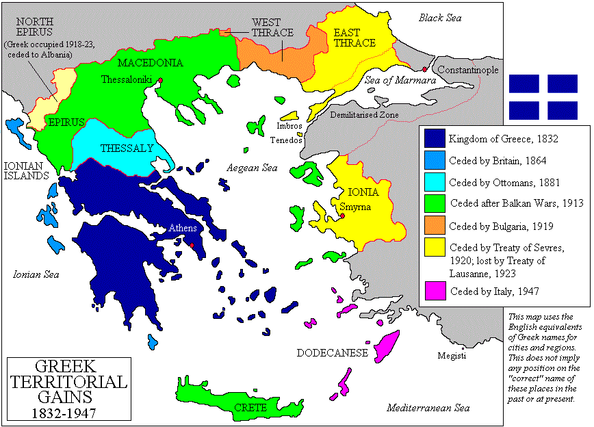
| АпісаннеTerritorial Expansion of Greece from 1832–1947.gif |
Čeština: Mapa zobrazuje územní expanzi Řeckého království (1832–1947). Dansk: Kort over Grækenlands territoriale udvidelser, 1832-1947. Deutsch: Territoriale Expansion Griechenlands 1832-1947. English: The territorial expansion of Greece, 1832-1947. Español: Mapa de la expansión territorial griega (1832-1947) Euskara: Greziaren lurralde hedapena 1832-1947 bitartean Français : L'expansion territoriale de la Grèce. 1832-1947. Hrvatski: Teritorijalno proširenje Grčke u razdoblju od 1832. do 1947. Italiano: L'espansione territoriale della Grecia dal 1832 al 1947 Magyar: Görögország területi növekedése (1832-1947) Occitan : Evolucions territòrialas de Grècia. Ελληνικά: Η εδαφική επέκταση της Ελλάδας 1832-1947. Македонски: Територијално проширување на Грција Українська: Територіальна експансія Греції (1832-1947). 日本語: ギリシャ王国の版図拡大 (1832-1947年) 中文: 希腊的领土变迁,1832年-1947年间。 العربية : خريطة تُصوِّر الأراضي التي استولت عليها اليونان مُنذُ سنة 1832م حين استقلالها عن الدولة العُثمانيَّة، وُصولًا إلى سنة 1947م |
||||||||
| Дата | |||||||||
| Крыніца | Imported from en:wikipedia by Christophe cagé 09:49, 15 October 2006 (UTC) | ||||||||
| Аўтар | en:User:Adam Carr | ||||||||
| Дазвол (Паўторнае выкарыстанне гэтага файла) |
Я, уладальнік аўтарскіх правоў на гэты твор, добраахвотна публікую яго на ўмовах наступных ліцэнзій:
Вы можаце выбраць любую з гэтых ліцэнзій. |
||||||||
| Іншыя версіі |
Derivative works of this file: Greek history from 1832.GIF
[правіць]
|


.PNG)


.png)


Назвы
Апішыце ў адным радку, што ўяўляе сабой гэты файл
Hellenic republic: territorial change 1832–1947
Yunanistanın ərazi genişlənməsi (1832-1947)
Элементы, адлюстраваныя на гэтым файле
адлюстроўвае
жнівень 2006
image/gif
Гісторыя файла
Націснуць на даце з часам, каб паказаць файл, якім ён тады быў.
| Дата і час | Драбніца | Памеры | Удзельнік | Тлумачэнне | |
|---|---|---|---|---|---|
| актуальн. | 05:07, 3 студзеня 2014 | | 868 × 624 (49 KB) | Spesh531 | update the year of Bulgarian losses, 1923 should be 1919 |
| 17:16, 15 ліпеня 2013 |  | 868 × 624 (28 KB) | Spesh531 | adding Bulgarian losses | |
| 02:23, 19 верасня 2011 |  | 868 × 624 (30 KB) | Vasarchit | corrected Epirus borderline | |
| 13:41, 19 верасня 2008 |  | 868 × 624 (30 KB) | Peeperman | {{Information |Description= |Source= |Date= |Author= |Permission= |other_versions= }} | |
| 12:50, 15 кастрычніка 2006 |  | 868 × 624 (29 KB) | Christophe cagé | ||
| 12:49, 15 кастрычніка 2006 |  | 868 × 624 (29 KB) | Christophe cagé | == Summary == Map created by User:Adam Carr, August 2006 - imported from en:wikipedia by ~~~~ == Licensing == {{GFDL-self}} Category:Maps of the history of Greece |
Выкарыстанне файла
Наступныя 3 старонкі выкарыстоўваюць гэты файл:
Глабальнае выкарыстанне файла
Гэты файл выкарыстоўваецца ў наступных вікі:
- Выкарыстанне ў az.wikipedia.org
- Выкарыстанне ў be-tarask.wikipedia.org
- Выкарыстанне ў bg.wikipedia.org
- Выкарыстанне ў br.wikipedia.org
- Выкарыстанне ў bs.wikipedia.org
- Выкарыстанне ў ca.wikipedia.org
- Выкарыстанне ў cv.wikipedia.org
- Выкарыстанне ў en.wikipedia.org
- History of modern Greece
- Macedonia (region)
- Enosis
- Treaty of Sèvres
- Greece–Turkey relations
- History of Greece
- Treaty of Constantinople (1832)
- Portal:Greece
- Talk:Megali Idea
- User talk:Maggas
- User:Adam Carr/My archive of original cartographic contributions
- User talk:Inawe
- Timeline of Eastern Orthodoxy in Greece (1821–1924)
- Greece–Turkey border
- Talk:Balkan Wars/Archive 1
- User:Biz/Greece-Turkey/background
- Greece–Ottoman Empire relations
- Portal:Greece/sandbox
- User:Falcaorib/Greece
- Выкарыстанне ў et.wikipedia.org
- Выкарыстанне ў fa.wikipedia.org
- Выкарыстанне ў fi.wikipedia.org
- Выкарыстанне ў hy.wikipedia.org
- Выкарыстанне ў io.wikipedia.org
- Выкарыстанне ў ka.wikipedia.org
- Выкарыстанне ў ko.wikipedia.org
- Выкарыстанне ў ku.wikipedia.org
- Выкарыстанне ў la.wikipedia.org
- Выкарыстанне ў lt.wikipedia.org
- Выкарыстанне ў lv.wikipedia.org
Паказаць глабальнае выкарыстанне гэтага файла.