File:Rzeczpospolita_1600.png
From Wikipedia, the free encyclopedia
Restr orin (2 000 × 1 568 piksel, ment ar restr : 329 Kio, seurt MIME : image/png)
![]()
| Tennet eo ar restr-mañ eus Wikimedia Commons ha gallout a ra bezañ implijet evit raktresoù all. Diskouezet eo deskrivadur he fajenn zeskrivañ amañ dindan. |

|
This historical map image could be re-created using vector graphics as an SVG file. This has several advantages; see Commons:Media for cleanup for more information. If an SVG form of this image is available, please upload it and afterwards replace this template with
{{vector version available|new image name}}.
It is recommended to name the SVG file “Rzeczpospolita 1600.svg”—then the template Vector version available (or Vva) does not need the new image name parameter. |
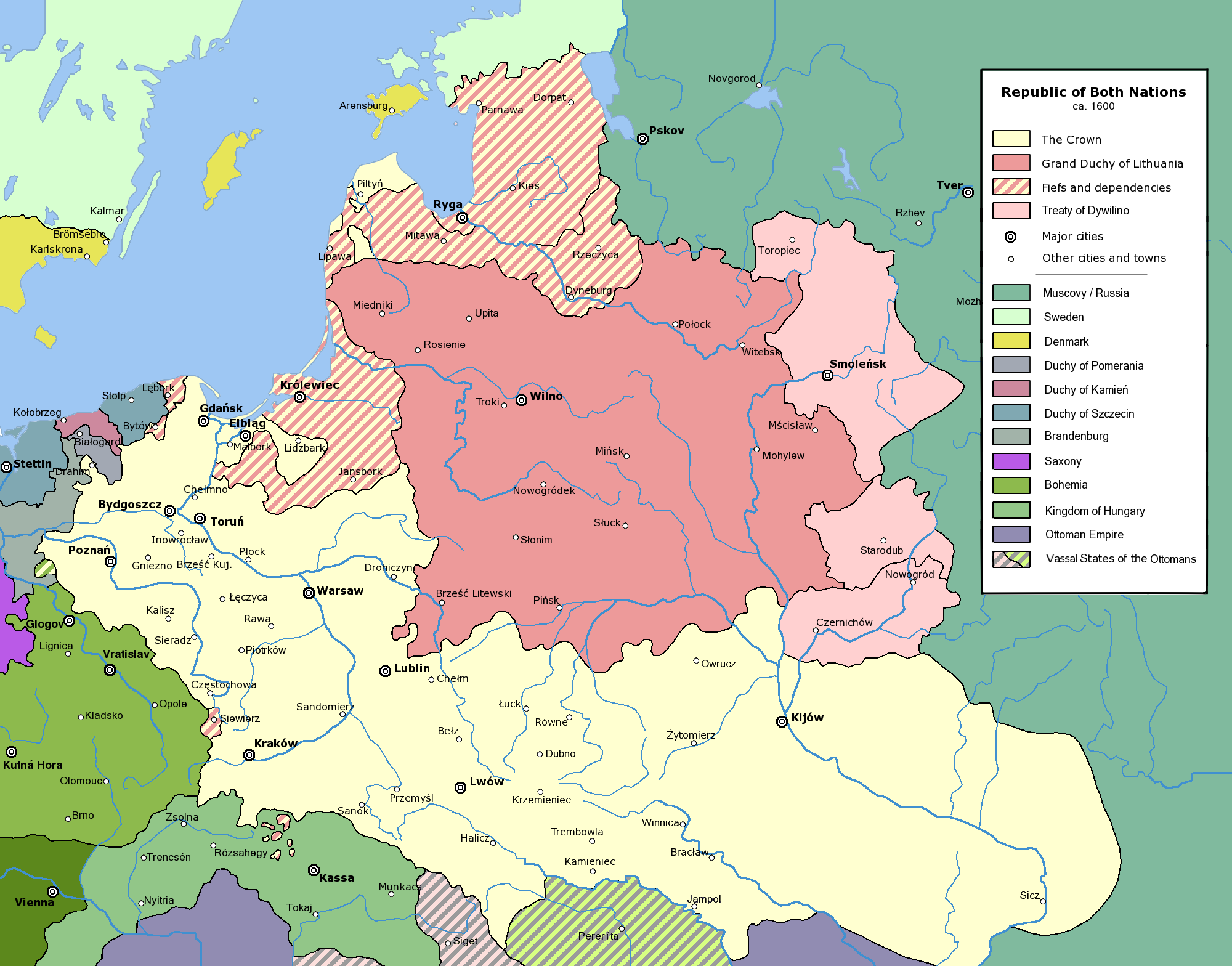
Commonwealth of Both Nations at the peak of its strength, after the Treaty of Dywilino.
The following is a list of maps created by Halibutt and uploaded to commons, as well as their present and projected derivatives.
| Parent Image | Image | Description | |||||||||||
|---|---|---|---|---|---|---|---|---|---|---|---|---|---|
| Maps by Halibutt | |||||||||||||
| Image:Rzeczpospolita.png | Image:Rzeczpospolita.png | The Republic in 17th and 18th century | |||||||||||
| Image:Rzeczpospolita 1600.png | The Republic after the Treaty of Dywilino | ||||||||||||
| Image:Rzeczpospolita voivodships.png | Voivodships of The Republic | ||||||||||||
| Image:Rzeczpospolita_Potop.png | The Republic during The Deluge and Chmielnicki Uprising, with major battles of the era marked | ||||||||||||
| Magnates and their lands and domains | |||||||||||||
| 1st • 2nd • 3rd | Partitions of Poland | ||||||||||||
| War of the constitution | |||||||||||||
| Image:Rzeczpospolita.xcf | SOURCE FILE - GIMP format | ||||||||||||
| Image:Poland 1939.png | Image:Poland 1939.png | Poland in 1939 | |||||||||||
| Image:Dywizje wrzesien 1.png | Order of Battle on September 1st, during the Polish Defence War of 1939 | ||||||||||||
| Image:Poland 1939.xcf | SOURCE FILE - GIMP format | ||||||||||||
| Image:Polska kontur bialy.png | Image:Polska kontur bialy.png | Contour map of Poland AD 1999, for use with various locator maps | |||||||||||
| Image:Rzeczpospolita 1923.png | Image:Rzeczpospolita 1923.png | Map of Poland 1918-1939, currently under development | |||||||||||
| Image:PBW March 1919.png | Polish-Bolshevik War - fronts in March of 1919 | ||||||||||||
| Image:PBW December 1919.png | Polish-Bolshevik War - fronts in December of 1919 | ||||||||||||
| Image:PBW June 1920.png | Polish-Bolshevik War - fronts in July of 1920 | ||||||||||||
| Image:PBW August 1920.png | Polish-Bolshevik War - fronts in August of 1920 | ||||||||||||
| Polish Defence War of 1939 | |||||||||||||
| Polish areas annexed by Germany, Lithuania, Slovakia and the Soviet Union | |||||||||||||
| German concentration camps in Poland | |||||||||||||
| Curzon line | |||||||||||||
| Major battles of the Polish-Bolshevik War | |||||||||||||
| names • no names | Polish/Czechoslovak/Lithuanian/German/Ukrainian claims in 1920's | ||||||||||||
| Image:Rzeczpospolita Central Lithuania.png | Central Lithuania | ||||||||||||
| Image:Rzeczpospolita Lithuania claims.png | Central Lithuania as compared with other Lithuanian claims | ||||||||||||
| Image:Rzeczpospolita 1789-1920.png | Post-1922 borders compared with the territory of Poland before the partitions | ||||||||||||
| Warsaw Uprising and the Operation Tempest | |||||||||||||
| Poland partitioned between the Soviets and the Germans | |||||||||||||
| Image:Rzeczpospolita 1939 Polish divisions.png | Polish divisions on September 1, 1939 | ||||||||||||
| Home Army inspectorates | |||||||||||||
| Image:Rzeczpospolita 1922.xcf | SOURCE FILE - GIMP format | ||||||||||||
| Image:Rzeczpospolita 1937.svg | Vector version!!!! | layered version available on request | |||||||||||
Since the legal status of the above comment has been questioned, I hereby grant anyone the right to treat it as either a standard copyright notice, invariant section, legal statement, legal advice, friendly suggestion or a mere comment, depending on his or hers own choice. |
|

derivative works
Derivative works of this file:
Captions
Items portrayed in this file
diskouez a ra
Istor ar restr
Klikañ war un deiziad/eur da welet ar restr evel ma oa da neuze.
| Deiziad/Eur | Munud | Mentoù | Implijer | Notenn | |
|---|---|---|---|---|---|
| red | 10 Gen 2016 da 15:53 | | 2 000 × 1 568 (329 Kio) | Spiridon Ion Cepleanu | Little cosmetic add in the south of the map (Ottoman domain) according with H.E.Stier (dir.) "Grosser Atlas zur Weltgeschischte", Westermann 1985, ISBN 3-14-10 0919-8, p. 103, and replaced Jampol on the left bank of the Dnister. |
| 24 C'hwe 2010 da 13:36 |  | 2 000 × 1 568 (319 Kio) | Dcoetzee | Remove watermark, PNGcrush | |
| 31 Gou 2005 da 20:45 |  | 2 000 × 1 568 (493 Kio) | Halibutt | Commonwealth of Both Nations at the peak of its strength, after the Treaty of Dywilino. {{User:Halibutt/maps}} {{User:Halibutt/GFDL}} Category:Historical maps of Poland Category:Historical maps of Ukraine Category:Historical maps of Russia |
Implij ar restr
Pajenn ebet ne implij ar restr-mañ.
Implij hollek ar restr
Ober a ra ar wikioù da-heul gant ar restr-mañ :
- Implij war an.wikipedia.org
- Implij war azb.wikipedia.org
- Implij war be.wikipedia.org
- Implij war ca.wikipedia.org
- Implij war cs.wikipedia.org
- Implij war da.wikipedia.org
- Implij war de.wikipedia.org
- Implij war en.wikipedia.org
- Implij war et.wikipedia.org
- Implij war fi.wikipedia.org
- Implij war fr.wikipedia.org
- Implij war fr.wiktionary.org
- Implij war gd.wikipedia.org
- Implij war hr.wikipedia.org
- Implij war id.wikipedia.org
- Implij war is.wikipedia.org
- Implij war it.wikipedia.org
- Implij war ja.wikipedia.org
- Implij war ka.wikipedia.org
- Implij war ko.wikipedia.org
- Implij war la.wikipedia.org
- Implij war lt.wikipedia.org
Gwelet muioc'h eus implij hollek ar restr-mañ.
Metaroadennoù
Titouroù ouzhpenn zo er restr-mañ; bet lakaet moarvat gant ar c'hamera niverel pe ar skanner implijet evit he niverelaat. Mard eo bet cheñchet ar skeudenn e-keñver he stad orin marteze ne vo ket kenkoulz munudoù zo e-keñver ar skeudenn kemmet.
| Pizhder led ar skeudenn | 28,35 dpc |
|---|---|
| Pizhder hed ar skeudenn | 28,35 dpc |