Restr:World_population_density_1994.png
From Wikipedia, the free encyclopedia
Ment ar rakweled-mañ : 800 × 475 piksel. pizhderioù all : 320 × 190 piksel | 640 × 380 piksel | 1 024 × 608 piksel | 1 280 × 761 piksel | 2 560 × 1 521 piksel | 6 693 × 3 977 piksel.
Restr orin (6 693 × 3 977 piksel, ment ar restr : 955 Kio, seurt MIME : image/png)
![]()
| Tennet eo ar restr-mañ eus Wikimedia Commons ha gallout a ra bezañ implijet evit raktresoù all. Diskouezet eo deskrivadur he fajenn zeskrivañ amañ dindan. |
Diverradur
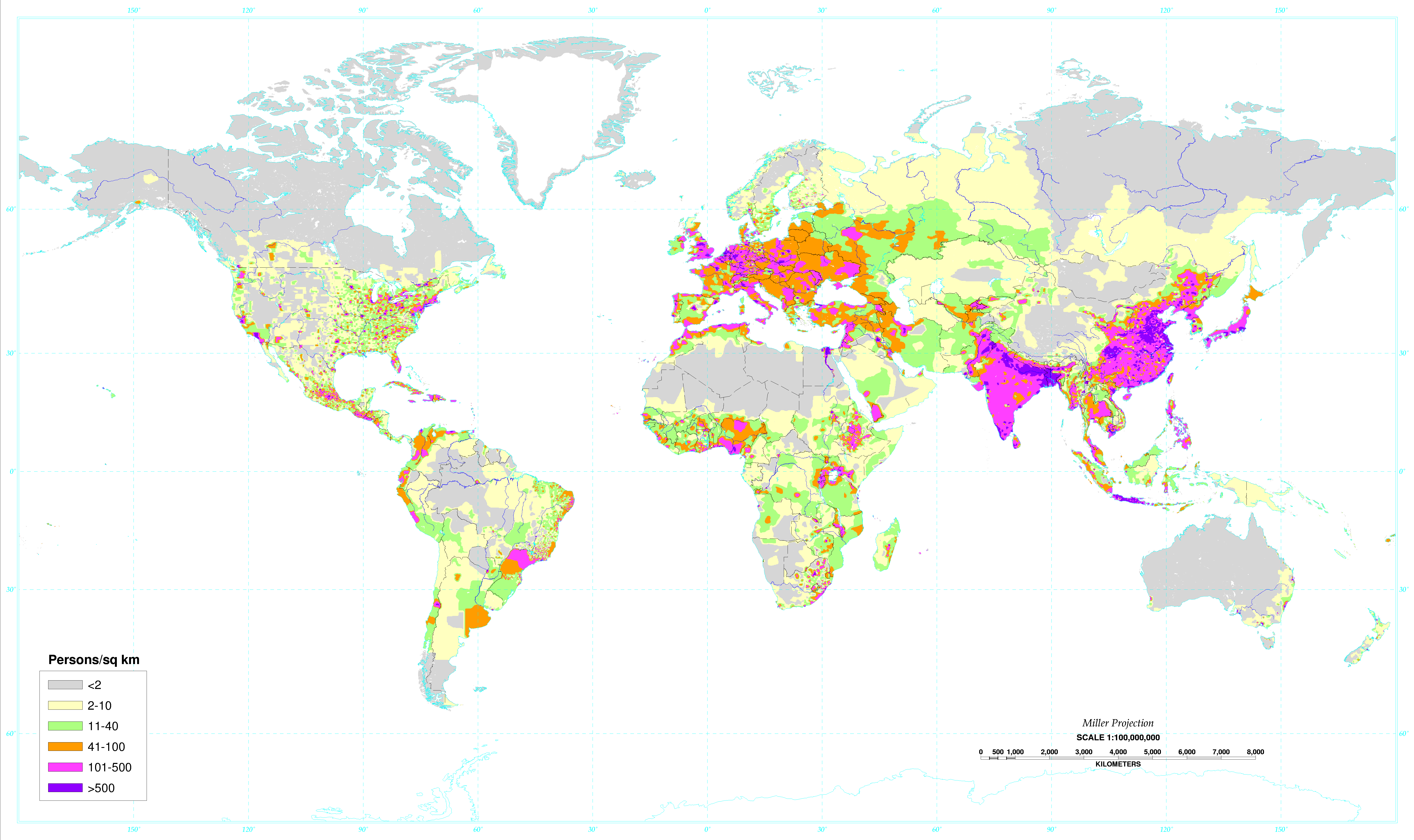
| DeskrivadurWorld population density 1994.png |
English: World map of the population density in 1994. A more recent population density map can be found at http://sedac.ciesin.columbia.edu/gpw/
Español: Mapa de la densidad de población mundial en 1994. Un mapa de densidad de población más reciente puede verse en http://sedac.ciesin.columbia.edu/gpw/. |
| Deiziad | Data from 1994. Image made in 2000. |
| Mammenn | Global Population Density Map. |
| Aozer | United States Department of Agriculture (USDA) |
| Stummoù all |
 World population density 1994 - with equator.png |

|
This map image could be re-created using vector graphics as an SVG file. This has several advantages; see Commons:Media for cleanup for more information. If an SVG form of this image is available, please upload it and afterwards replace this template with
{{vector version available|new image name}}.
It is recommended to name the SVG file “World population density 1994.svg”—then the template Vector version available (or Vva) does not need the new image name parameter. |
Aotre-implijout
| Public domainPublic domainfalsefalse |
This work is in the public domain in the United States because it is a work prepared by an officer or employee of the United States Government as part of that person’s official duties under the terms of Title 17, Chapter 1, Section 105 of the US Code.
Note: This only applies to original works of the Federal Government and not to the work of any individual U.S. state, territory, commonwealth, county, municipality, or any other subdivision. This template also does not apply to postage stamp designs published by the United States Postal Service since 1978. (See § 313.6(C)(1) of Compendium of U.S. Copyright Office Practices). It also does not apply to certain US coins; see The US Mint Terms of Use.
|
 | |
| Rummet eo bet ar restr-mañ e-touez ar restroù hep strishadurioù implij anavezet evit ar pezh a sell ouzh ar gwirioù aozer, ha kement-se evit an holl wirioù kar ha stag. | ||
https://creativecommons.org/publicdomain/mark/1.0/PDMCreative Commons Public Domain Mark 1.0falsefalse
Istor ar restr
Klikañ war un deiziad/eur da welet ar restr evel ma oa da neuze.
| Deiziad/Eur | Munud | Mentoù | Implijer | Notenn | |
|---|---|---|---|---|---|
| red | 4 Mae 2020 da 02:34 | | 6 693 × 3 977 (955 Kio) | XyKyWyKy | correction - uploaded the wrong file |
| 4 Mae 2020 da 02:31 |  | 6 693 × 3 977 (954 Kio) | XyKyWyKy | color adjustment for better contrast | |
| 5 Eos 2019 da 11:31 |  | 6 693 × 3 977 (916 Kio) | SinPantuflas | Removed old Panama Canal Zone delimitation from the map. Updated density in Panama Province and Colon (approx). | |
| 7 Gen 2014 da 15:18 |  | 6 693 × 3 977 (915 Kio) | Nonenmac | Removed the black border, title and publisher info. | |
| 20 Her 2013 da 09:08 |  | 7 021 × 4 543 (951 Kio) | McZusatz | RGB from http://soils.usda.gov/use/worldsoils/mapindex/popden-map.zip (uploaded using chunked upload script) | |
| 20 Her 2013 da 08:55 |  | 7 021 × 4 543 (519 Kio) | McZusatz | Merging details from duplicate file (uploaded using chunked upload script) | |
| 29 Gwe 2013 da 20:21 |  | 7 021 × 4 543 (951 Kio) | Bürgerentscheid | Reverted to version as of 13:47, 4 September 2011, MediaWiki software now supports PNGs with higher resolution | |
| 4 Gwe 2011 da 13:47 |  | 1 300 × 841 (166 Kio) | Genetics4good | Reverted to version as of 03:04, 2 January 2006 | |
| 4 Gwe 2011 da 13:47 |  | 7 021 × 4 543 (951 Kio) | Genetics4good | Improved resolution, now possible to zoom in much more | |
| 2 Gen 2006 da 03:04 |  | 1 300 × 841 (166 Kio) | QuartierLatin1968 | From en:Image:World_population_density.gif. World map of the population density in 1994. Made in 2001 by the U.S. departement of agriculture. [http://antwrp.gsfc.nasa.gov/apod/ap030305.html Astronomy Picture of the Day], 2003 March 5. Converted to pn |
Implij ar restr
Implijout a ra ar bajenn da heul ar restr-mañ :
Implij hollek ar restr
Ober a ra ar wikioù da-heul gant ar restr-mañ :
- Implij war ast.wikipedia.org
- Implij war av.wikipedia.org
- Implij war ce.wikipedia.org
- Implij war da.wikipedia.org
- Implij war da.wikibooks.org
- Implij war de.wikipedia.org
- Implij war el.wikipedia.org
- Implij war en.wikipedia.org
- Implij war eo.wikipedia.org
- Implij war es.wikipedia.org
- Implij war eu.wikipedia.org
- Implij war fo.wikipedia.org
- Implij war fr.wikipedia.org
- Implij war hr.wikipedia.org
- Implij war hy.wikipedia.org
- Implij war incubator.wikimedia.org
- Implij war ja.wikipedia.org
- Implij war ja.wikibooks.org
- Implij war ko.wikipedia.org
- Implij war kw.wikipedia.org
- Implij war li.wikipedia.org
- Implij war nl.wikipedia.org
- Implij war no.wikipedia.org
- Implij war pl.wikipedia.org
- Implij war pnb.wikipedia.org
- Implij war ro.wikipedia.org
- Implij war sq.wikipedia.org
- Implij war th.wikipedia.org
- Implij war uk.wikipedia.org
- Implij war ur.wikipedia.org
- Implij war vi.wikipedia.org
- Implij war zh.wikipedia.org
Metaroadennoù
Titouroù ouzhpenn zo er restr-mañ; bet lakaet moarvat gant ar c'hamera niverel pe ar skanner implijet evit he niverelaat. Mard eo bet cheñchet ar skeudenn e-keñver he stad orin marteze ne vo ket kenkoulz munudoù zo e-keñver ar skeudenn kemmet.
| Pizhder led ar skeudenn | 161,81 dpc |
|---|---|
| Pizhder hed ar skeudenn | 161,81 dpc |
Adtapet diwar « https://br.wikipedia.org/wiki/Restr:World_population_density_1994.png »