File:Expulsion_map_of_the_Circassians_in_19th_century.PNG
From Wikipedia, the free encyclopedia
No hi ha cap versió amb una resolució més gran.
Expulsion_map_of_the_Circassians_in_19th_century.PNG (491 × 445 píxels, mida del fitxer: 15 Ko, tipus MIME: image/png)
| Aquest fitxer i la informació mostrada a continuació provenen del dipòsit multimèdia lliure Wikimedia Commons. |
Resum
| DescripcióExpulsion map of the Circassians in 19th century.PNG |
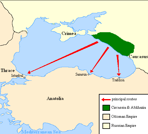
English: Map showing the location of Circassia and the expulsion routes (1859-1864) of the Circassians and other Caucasian peoples to the Ottoman Empire, after the Russian annexation of the North-Caucasus following the Crimean War of 1853-1856.
I used the information of the following two maps: http://www.circassianworld.com/CIRCASSIA1840.jpg And the books: The Northwest Caucasus: past, present, future, Walter Richmond The forgotten minorities of Eastern Europe, Arno TannerРусский: Карта с указанием местонахождения Черкесии и высылки маршрутов (1859-1864) от черкесов и других кавказских народов в состав Османской империи, после русской аннексии Северо-Кавказского следующие Крымской войны 1853-1856 гг. |
| Data | |
| Font | Treball propi |
| Autor | DragonTiger23 |
Llicència
| Public domainPublic domainfalsefalse |
| Jo, el titular del copyright d'aquesta obra, l'allibero al domini públic. Això s'aplica a tot el món. En alguns països això pot no ser legalment possible, en tal cas: Jo faig concessió a tothom del dret d'usar aquesta obra per a qualsevol propòsit, sense cap condició llevat d'aquelles requerides per la llei. |
Llegendes
Afegeix una explicació d'una línia del que representa aquest fitxer
Elements representats en aquest fitxer
representa l'entitat
Algun valor sense element de Wikidata
11 feb 2011
Historial del fitxer
Cliqueu una data/hora per veure el fitxer tal com era aleshores.
| Data/hora | Miniatura | Dimensions | Usuari/a | Comentari | |
|---|---|---|---|---|---|
| actual | 22:06, 5 jul 2013 | | 491 × 445 (15 Ko) | Irānshahr | |
| 04:01, 4 jul 2013 |  | 491 × 445 (15 Ko) | Irānshahr | Olahus is correct. | |
| 11:23, 3 jul 2013 |  | 491 × 445 (15 Ko) | DragonTiger23 | Reverted to version as of 18:05, 11 February 2011 | |
| 15:23, 9 des 2011 |  | 491 × 445 (15 Ko) | Olahus | The Circassian inhabited region was actually much bigger. | |
| 20:05, 11 feb 2011 |  | 491 × 445 (15 Ko) | DragonTiger23 | {{Information |Description ={{en|1=Map showing the location of Circassia and the expulsion routes (1859-1864) of the Circassians and other Caucasian peoples to the Ottoman Empire, after the Russian annexation of the North-Caucasus following the Crimean |
Ús del fitxer
La pàgina següent utilitza aquest fitxer:
Ús global del fitxer
Utilització d'aquest fitxer en altres wikis:
- Utilització a bg.wikipedia.org
- Utilització a de.wikipedia.org
- Utilització a it.wikipedia.org
- Utilització a ja.wikipedia.org
- Utilització a lmo.wikipedia.org
- Utilització a nl.wikipedia.org
- Utilització a pl.wikipedia.org
- Utilització a ru.wikipedia.org
- Utilització a ru.wikinews.org
- Utilització a sh.wikipedia.org
- Utilització a tr.wikipedia.org