
Kalchreuth
Municipality in Bavaria, Germany / From Wikipedia, the free encyclopedia
Dear Wikiwand AI, let's keep it short by simply answering these key questions:
Can you list the top facts and stats about Kalchreuth?
Summarize this article for a 10 year old
SHOW ALL QUESTIONS
Kalchreuth is a municipality in the district of Erlangen-Höchstadt, in Bavaria, Germany. It is located 10 kilometers east of Erlangen and 15 kilometers north of Nuremberg and contains the villages of Kalchreuth, Käswasser and Röckenhof and also the hamlets of Stettenberg, Minderleinsmühle and Gabermühle.
Quick Facts Country, State ...
Kalchreuth | |
|---|---|
 Kalchreuth Castle | |
 Coat of arms | |
Location of Kalchreuth within Erlangen-Höchstadt district 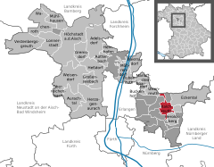 | |
 Kalchreuth  Kalchreuth | |
| Coordinates: 49°34′N 11°08′E | |
| Country | Germany |
| State | Bavaria |
| Admin. region | Mittelfranken |
| District | Erlangen-Höchstadt |
| Government | |
| • Mayor (2020–26) | Herbert Saft[1] (FW) |
| Area | |
| • Total | 10.84 km2 (4.19 sq mi) |
| Elevation | 413 m (1,355 ft) |
| Population (2022-12-31)[2] | |
| • Total | 3,037 |
| • Density | 280/km2 (730/sq mi) |
| Time zone | UTC+01:00 (CET) |
| • Summer (DST) | UTC+02:00 (CEST) |
| Postal codes | 90562 |
| Dialling codes | 0911 |
| Vehicle registration | ERH |
| Website | www.kalchreuth.de |
Close