Top Qs
Timeline
Chat
Perspective
Kongo Central
Province of the Democratic Republic of the Congo From Wikipedia, the free encyclopedia
Remove ads
Kongo Central (Kongo: Kongo dia Kati[4][5]), formerly Bas-Congo, is one of the 26 provinces of the Democratic Republic of the Congo.[6] Its capital is Matadi.
Remove ads
History
At the time of independence, the area now encompassing Kongo Central was part of the greater province of Léopoldville, along with the capital city of Kinshasa and the districts of Kwango, Kwilu and Mai-Ndombe. Under Belgian colonial rule, the province was known as Bas-Congo (as in "Lower Congo River") and was renamed Kongo Central after independence.[7][8]
Under the regime of Mobutu Sese Seko from 1965 to 1997, the Congo river was renamed as Zaire. The province was named as Bas-Zaïre. The name was later reverted to Bas-Congo. It was subsequently renamed as Kongo Central in 2015.
Remove ads
Geography
Summarize
Perspective

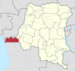
Kongo Central is the only province in the country with an ocean coastline; it has narrow frontage on the Atlantic Ocean to the west. It borders the city-province of Kinshasa to the north-east, the province of Kwango to the east, and the Republic of Angola to the south as well as the Republic of the Congo and Cabinda to the north.
The lower Congo River traverses the province from the north-east to the south-west. It is navigable from the Atlantic Ocean to the port city of Matadi after which there are a series of rapids that make it unnavigable until the Malebo Pool.
Divisions
The provincial capital is Matadi, with Boma being the other official city. The remainder of the province is administratively divided into ten territories, the most of any province:[9]
Before 2015 these territories were divisions of the Bas-Fleuve, Cataractes and Lukaya districts; except for Moanda, which was attached to Boma (a city/district hybrid).[10]
Towns with their 2010 populations are:
Remove ads
Notable people from Kongo Central
- Afonso I of Kongo, the sixth ruler of the Kingdom of Kongo.
- Zamenga Batukezanga, writer, was born in Kongo Central.
- Paul Panda Farnana, first Congolese with Belgian diploma of higher education.
- Thomas Kanza, Congolese diplomat. He was one of the first Congolese nationals to graduate from a university.
- Sophie Kanza, first Congolese woman to obtain a university degree; politician and sociologist).
- Joseph Kasa-Vubu, Democratic Republic of the Congo first president.
- Simon Kimbangu, founder of Christian new religious movement Kimbanguism.
- Ray Lema, France-based pianist, guitarist, and songwriter.
- François Luambo Luanzo Makiadi, virtuoso Congolese Rumba guitarist and singer.
- Ne Muanda Nsemi, Bundu dia Kongo leader.
Citations
General and cited references
External links
Wikiwand - on
Seamless Wikipedia browsing. On steroids.
Remove ads


