
Pitsiulartok
Island in Nunavut, Canada / From Wikipedia, the free encyclopedia
Pitsiulartok or Pituilaktok (formerly Fairway Island)[1] is a small, uninhabited island located at 63°15'N, 90°33'W[2] in Hudson Bay, about 13 km[3] from the community of Chesterfield Inlet, Nunavut, Canada. The narrow island is about 3.5 km in length and barely 1 km wide at its widest point. Traditionally it was a walrus-hunting ground for the local Inuit,[2] and a landmark for southern whalers.[4] It is part of a loose chain of small islands running along the coast, including Sakpik Island and Promise Island.
Quick Facts Geography, Location ...
 | |
 Pitsiulartok (Formerly "Fairway Island")  Pitsiulartok (Formerly "Fairway Island") | |
| Geography | |
|---|---|
| Location | Hudson Bay |
| Coordinates | 63°15′N 090°33′W |
| Administration | |
Canada | |
| Nunavut | Nunavut |
| Region | Kivalliq |
| Demographics | |
| Population | Uninhabited |
Close
The name "Pituilaktok" comes from the Inuktitut name for a local bird known in English as the black guillemot (cepphus grylle), "pitiula".[5]
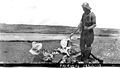 Fairway Island, early 1920s. Subject unidentified. Photo by Hudson's Bay Company employee Capt. George Cleveland of the motor schooner Fort Chesterfield.
