
Vltava
Longest river in the Czech Republic / From Wikipedia, the free encyclopedia
Dear Wikiwand AI, let's keep it short by simply answering these key questions:
Can you list the top facts and stats about Vltava?
Summarize this article for a 10 year old
SHOW ALL QUESTIONS
This article is about the river in the Czech Republic. For the composition by Bedřich Smetana, see Má vlast. For the restaurant in Helsinki, Finland, see Vltava (restaurant).
The Vltava (/ˈvʊltəvə, ˈvʌl-/ VU(U)L-tə-və,[1][2][3] Czech: [ˈvl̩tava] ⓘ; German: Moldau [ˈmɔldaʊ] ⓘ) is the longest river in the Czech Republic, running southeast along the Bohemian Forest and then north across Bohemia, through Český Krumlov, České Budějovice, and Prague, and finally merging with the Elbe at Mělník. It is commonly referred to as the "Czech national river".[4]
Quick Facts Location, Country ...
| Vltava | |
|---|---|
 Vltava in Prague | |
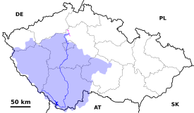  The course and drainage basin of the Vltava from its source to its confluence with the Elbe (magenta) | |
| Location | |
| Country | Czech Republic |
| Regions | |
| Cities | |
| Physical characteristics | |
| Source | Černý potok [cs] |
| • location | Černá hora, Bohemian Forest |
| • coordinates | 48°58′29″N 13°33′39″E |
| • elevation | 1,172 m (3,845 ft) |
| Mouth | Elbe |
• location | Mělník |
• coordinates | 50°20′29″N 14°28′30″E |
• elevation | 155 m (509 ft) |
| Length | 430.3 km (267.4 mi) |
| Basin size | 28,090 km2 (10,850 sq mi) |
| Discharge | |
| • average | 149.9 m3/s (5,290 cu ft/s) |
| Basin features | |
| Progression | Elbe→ North Sea |
| Tributaries | |
| • left | Otava, Berounka |
| • right | Lužnice, Sázava |
Close