Top Qs
Timeline
Chat
Perspective
Alam-Kuh
Mountain in Iran From Wikipedia, the free encyclopedia

Remove ads
Alam-Kūh (Persian: علمکوه; also: Alam Kooh) or Mount Alam is a mountain in Alborz mountain range in northern Iran, Mazandaran Province, forming a peak of Takht-e Suleyman Massif. It is located in Kelardasht District of Mazandaran Province. With an elevation of 4,828 meters, it is the second-highest peak in Iran after Mount Damavand.[2]

Remove ads
Climbing history

The first recorded ascent of the peak was made from Hazarchal over the south face by the German Bornmüller brothers during their six-month botanical exploration of the Alborz in 1902.[3][4]
Douglas Busk, a British mountaineer, climbed Alam-Kuh via the east ridge in 1933 and again in 1934 from over the west ridge.[5]
The 800 m high, steep granite north face provides some of the most difficult and challenging mountaineering routes in the country and the climbs rank alongside major climbing routes in the European Alps. In addition to local climbers, the north face attracts European climbing teams. The first known ascent from the north was by a German party (Gorter/Steinauer) in 1936 via the northwest ridge.[6]
2004 earthquake
Most of the fixed ropes were severely damaged during a major 6.3 magnitude earthquake[7] and consequent rockfall in 2004. The mountain was closed to climbers for some months because of the hazard of rockfall and loose cables.
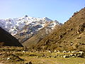
Terrain and approach
The mountain range supports permanent snow and glaciers.
Remove ads
Location

Remove ads
Gallery
 Tang-e Galu
 Tang-e Galu
 Tang-e Galu
 Tang-e Galu
 Tang-e Galu
 Hesarchal Lake
 Hesarchal Camp
 Hesarchal Lake
 Hesarchal Lake
 Hesarchal Lake
 Hesarchal Lake


See also
References
External links
Wikiwand - on
Seamless Wikipedia browsing. On steroids.
Remove ads