Top Qs
Timeline
Chat
Perspective
Awat County
County in Xinjiang, China From Wikipedia, the free encyclopedia

Remove ads
Awat County[4][5][6] (Uyghur: ئاۋات ناھىيىسى) is a county in Aksu Prefecture, Xinjiang Uyghur Autonomous Region, China. Awat County is located on the southern foot of the Tian Shan mountain range and on the northern edge of the Taklamakan Desert.[2][7]
.png)


Remove ads
History
Summarize
Perspective
The term "Awat" translates from Uyghur to signify "prosperity".[8] The region surrounding Awat County was formerly known as "Dolang," the ancestral home of the "Dolang people," an old Uyghur tribe. Subsequently, a significant influx of peasants settled in the region, resulting in a population surge, an expansion of cultivated land, and a daily transformation of the landscape, prompting the renaming to Awat.[9]
During the Han Dynasty, it was part of Gumo. During the Tang Dynasty, it was part of Gumo Prefecture.[10][11] In 1883, Aksu Dao was established, with Awat falling under its control. In 1913, the area was part of the three, four, and five districts of Aksu County; in 1922, Awat County was established. Awat County was established in 1930,[12] initially part of Aksu Dao, and subsequently became part of the Aksu District Administrator's Office in 1933. In 1943, it pertains to the Aksu Administrative Inspector General's Office.[13] The People's Government of the County of Awat was officially created in 1950.[14] Subsequently, it has been governed by the Aksu Commissioner's Office and the Aksu Regional Administrative Office.[15]
On January 23, 2013, the People's Government of Xinjiang Uygur Autonomous Region (Xin Zheng Xin [2013] No. 17) sanctioned the transfer of 474.208 square kilometers of Awat County to Aral City's administration.[16]
Remove ads
Administrative divisions
Summarize
Perspective
Awat County is made up of seven towns, two townships and one other area:[2][12][17]
Remove ads
Demographics
As of 1999, 81.59% of the population of Awat (Awati) County was Uyghur and 17.74% of the population was Han Chinese.[23]
According to the 2010 Sixth Population Census, the total resident population of Awati County was 237,562. As of 2015, 217,722 of the 262,842 residents of the county were Uyghur, 42,960 were Han Chinese, 2,160 were from other ethnic groups.[24]
Climate
Remove ads
Economy
A developed irrigation system is in place and agricultural products include wheat, rice, corn and cotton. Sheep are the primary livestock in the county. Industries include coal, construction, food processing, leathermaking and carpetmaking.[27]
One quarter of the cotton production in Aksu prefecture comes from the county.[28]
Historical maps
Historical English-language maps including Awat:
 Map including Awat (1917)
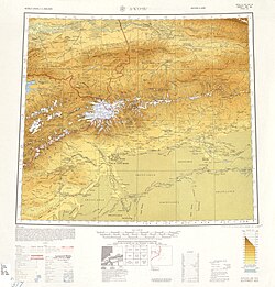 Map including Awat (labeled as A-wa-t'i (Abad)) and surrounding region from the International Map of the World (AMS, 1950)[b]
 Map including Awat (DMA, 1981)
_p61_PLATE19._SINKIANG_(14597194848).jpg)
_-_panoramio.jpg)


Notes
- Locals in Xinjiang frequently observe UTC+6 (Xinjiang Time), 2 hours behind Beijing.
References
Wikiwand - on
Seamless Wikipedia browsing. On steroids.
Remove ads