Top Qs
Timeline
Chat
Perspective
Baranya County
County of Hungary From Wikipedia, the free encyclopedia

Remove ads
Baranya (Hungarian: Baranya vármegye, pronounced [ˈbɒrɒɲɒ ˈvaːrmɛɟɛ]; German: Branau; Croatian: Baranjska županija) is a county (vármegye) in southern Hungary.[4] It is part of the Southern Transdanubia statistical region and the historical Baranya region, which was a county (comitatus) in the Kingdom of Hungary dating back to the 11th century. Its current status as one of the 19 counties of Hungary was established in 1950 as part of wider Soviet administrative territorial reform following World War II. Its county seat and largest city is Pécs.
This article needs additional citations for verification. (December 2015) |


As of 2025, it has a population of 351,158. Of the 19 counties of Hungary (excluding Budapest), it is ranked 10th, both in terms of geographic area and population.[5]
Remove ads
Etymology
In German, it is known as Komitat Branau, and in Croatian as Baranjska županija (Baranja).
The county was probably named after its first comes 'Brana' or 'Braina'.
Geography
Summarize
Perspective
This county has a total area of 4,429.60 km2 (1,710 sq mi) – 4.76% of Hungary – which is divided in Upper Baranya and Lower Baranya.
It is bordered by Somogy County to the northwest, Tolna County to the north, Bács-Kiskun County and the Danube to the east, and the border with Croatia (part of which is formed by the Drava River) to the south.
The northern part of the county is a mountain area with large forests, the Mecsek Mountains. The central areas are shared between the Baranya Hills and Villány Mountains. The very eastern and southern parts are flat.
The highest point in the county is Zengő in the Mecsek Mountains, at 682 metres. This is also the highest point of the mountain range.
Baranya is rich in mineral and thermal water, and also in other resources. 98% of Hungary's coal resources are found here.
Neighbours
- Tolna County in the North.
- Bács-Kiskun County in the East. (across the Danube river)
- Croatia in the south (across the Drava river) – Osijek-Baranja County and Virovitica-Podravina County
- Somogy County in the Northwest.
Climate
The climate of Baranya is a mix of continental and temperate, which makes it unique in Hungary, as the rest of the country is primarily continental. Its milder climate is due to its southern location and relative proximity to the Mediterranean Sea in comparison to other parts of the country, leaving it with warmer winters. It has the highest average annual rainfall of the Hungarian counties and a high amount of sunshine hours.[citation needed]

Remove ads
History
Summarize
Perspective
The area has been inhabited since ancient times. Before the Hungarian tribes conquered the area, it was inhabited by Slavs and Avars. Stephen I founded an episcopal seat here.
In 1526, the county was occupied by Ottomans and was freed in 1689. Its medieval borders remained unchanged until 1919. According to the peace treaty of Trianon, the southern part of the county (1,163 km2, 449 sq mi) reverted to Slavic rule (present-day Croatia). The re-organizing of the counties (1950) brought only minor changes (town of Szigetvár got there).
Baranya has the largest number of minorities in Hungary (more than twice the country average), providing home to 34% of the German minority, the so-called Danube Swabians, and 32% of the Southern Slav minorities in Hungary.
The Stifolder or Stiffoller Shvove are a Roman Catholic subgroup of the so-called Danube Swabians. Their ancestors once came ca. 1717 - 1804 from the Hochstift Fulda and surroundings (Roman Catholic Diocese of Fulda), and settled in Baranya.[7] They retained their own German dialect and culture, until the end of WW2. After WW2, the majority of Danube Swabians were expelled to allied-occupied Germany and allied-occupied Austria, in accordance with the 1945 Potsdam Agreement.[8]
Only a few people can speak the old Stiffolerisch Schvovish dialect. Also a sausage(kolbász) named after these people.[9]
[10] Electoral History
Demographics
Summarize
Perspective
As of 2025, the county has a population of 351,158 with a population density of 79/km2.
Religion in Baranya County (2022 census – of those who declared their religion (59.7%))
- Roman Catholic (57.5%)
- Calvinistic (8.90%)
- Lutheran (1.60%)
- Faith Church (0.50%)
- Greek Catholic (0.50%)
- Other Christian denominations (3.70%)
- Other religion (0.60%)
- Not religious (26.7%)
2011 census
As of the census of 2011, there were 386,441 residents, 160,040 households, and 105,646 families living in the county. The population density was 87 inhabitants per square kilometres(227/sqmi). There were 167,453 housing units at an average density of 38per square kilometre (98/sqmi).
There were 160,040 households, of which 63.2% were one-family households, 1.4% were multi-family households, 32.1% were one-person households, and 3.4% were other non-family households. Elderly individuals living alone were 15.9% of all households. The average household size was 2.34.
There were 105,646 families, of which 44.1% were married couples or consensual unions living together with children, 36.4% were couples without children, 16.7% were single females with children, and 2.8% were single males with children. The average family size was 2.82.
The age breakdown of the county was 20.1% under the age of 20, 7.0% between ages 20 and 24, 27.4% aged 25 to 44, 28.3% aged 45 to 64, and 17.2% aged 65 or older. The gender makeup of the county was 47.2% male and 52.8% female.
Religious adherence in the county was 46.8% Roman Catholic, 6.4% Reformed (Calvinist), 1.2% Evangelical (Lutheran), 0.3% Greek Catholic, 0.1% Orthodox, and 1.5% other religions. The non-religious were 16.2% and atheists were 1.5%, with 26.0% declining to answer.[13]
2001 census
As of the census of 2001, there were 407,448 residents, 151,956 households, and 115,946 families living in the county. The population density was 238 inhabitants per square mile (92/km2). There were 156,632 housing units at an average density of 92 per square mile (35/km2).
There were 151,956 households, of which 68.5% were one-family households, 3.8% were multi-family households, 24.9% were one-person households, and 2.7% were other non-family households. Elderly individuals living alone were 13.1% of all households. The average household size was 2.60.
There were 115,946 families, of which 48.7% were married couples or consensual unions living together with children, 35.4% were couples without children, 13.7% were single females with children, and 2.1% were single males with children. The average family size was 2.87.
The age breakdown of the county was 23.0% under the age of 20, 8.1% between ages 20 and 24, 28.0% aged 25 to 44, 26.0% aged 45 to 64, and 14.9% aged 65 or older. The gender makeup of the county was 47.5% male and 52.5% female.
Religious adherence in the county was 64.2% Roman Catholic, 8.7% Reformed (Calvinist), 1.5% Evangelical (Lutheran), 0.5% Greek Catholic, 0.1% Orthodox, and 0.8% other religions. The non-religious were 13.4%, with 10.8% declining to answer.[14][13]
Ethnicity
Besides the Hungarian majority, the main minorities are the Germans (approx. 22,000), Roma (17,000), Croats (6,000), and Serbs (500).
Total population (2011 census): 386,441
Ethnic groups (2011 census):[15]
Identified themselves: 364,801 persons:
- Hungarians: 315,713 (86.54%)
- Germans: 22,150 (6.07%)
- Romani: 16,995 (4.66%)
- Croats: 6,343 (1.74%)
- Others and indefinable: 3,600 (0.99%)
Approx. 58,000 persons in Baranya County did not declare their ethnic group at the 2011 census.
Remove ads
Regional structure

| No. | English and Hungarian names |
Area (km2) |
Population (2011) |
Density (pop./km2) |
Seat | No. of municipalities |
| 1 | Bóly District Bólyi járás |
220.03 | 11,956 | 54 | Bóly | 16 |
| 2 | Hegyhát District Hegyháti járás |
360.72 | 12,744 | 35 | Sásd | 25 |
| 3 | Komló District Komlói járás |
292.48 | 35,489 | 121 | Komló | 20 |
| 4 | Mohács District Mohácsi járás |
600.98 | 35,164 | 59 | Mohács | 26 |
| 5 | Pécs District Pécsi járás |
623.07 | 189,036 | 303 | Pécs | 40 |
| 6 | Pécsvárad District Pécsváradi járás |
246.44 | 11,931 | 48 | Pécsvárad | 17 |
| 7 | Sellye District Sellyei járás |
493.69 | 14,192 | 29 | Sellye | 38 |
| 8 | Siklós District Siklósi járás |
652.99 | 35,929 | 55 | Siklós | 53 |
| 9 | Szentlőrinc District Szentlőrinci járás |
282.43 | 14,998 | 53 | Szentlőrinc | 21 |
| 10 | Szigetvár District Szigetvári járás |
656.76 | 25,002 | 38 | Szigetvár | 45 |
| Baranya County | 4,429.59 | 386,446 | 87 | Pécs | 301 | |
|---|---|---|---|---|---|---|
Remove ads
Politics
Summarize
Perspective
.jpg)
County Assembly
The Baranya County Council, elected at the 2019 local government elections, is made up of 18 counselors, with the following party composition:[16]
President of the Assembly
Members of the National Assembly
The following members elected of the National Assembly during the 2022 parliamentary election:[18]
Remove ads
Municipalities
Summarize
Perspective
Baranya County has 1 urban county, 13 towns, 3 large villages and 284 villages.

Like Borsod-Abaúj-Zemplén, Baranya is a county of extremes when it comes to regional structure. The county seat is one of the five largest cities (and three largest agglomerations) of Hungary, but more than 2/3 of the municipalities are small hamlets with a population under 500. Half of the county's population lives in the county seat or in its immediate vicinity, while 22% of the population lives in villages that have less than 1000 inhabitants.
- Cities with county rights
(ordered by population, as of 2011 census)
- Pécs (156,049) – county seat
- Towns
- Villages
- Abaliget
- Adorjás
- Almamellék
- Almáskeresztúr
- Alsómocsolád
- Alsószentmárton
- Apátvarasd
- Aranyosgadány
- Ág
- Áta
- Babarc
- Babarcszőlős
- Bakóca
- Bakonya
- Baksa
- Baranyahídvég
- Baranyajenő
- Baranyaszentgyörgy
- Basal
- Bánfa
- Bár
- Belvárdgyula
- Beremend

- Berkesd
- Besence
- Bezedek
- Bicsérd
- Bikal
- Birján
- Bisse
- Boda
- Bodolyabér
- Bogdása
- Bogád
- Bogádmindszent
- Boldogasszonyfa
- Borjád
- Bosta
- Botykapeterd
- Bükkösd
- Bürüs
- Csányoszró
- Csarnóta
- Csebény
- Cserdi
- Cserkút
- Csertő
- Csonkamindszent
- Cún
- Drávacsehi
- Drávacsepely
- Drávafok
- Drávaiványi
- Drávakeresztúr
- Drávapalkonya
- Drávapiski
- Drávaszabolcs
- Drávaszerdahely
- Drávasztára
- Dencsháza
- Dinnyeberki
- Diósviszló
- Dunaszekcső
- Egerág
- Egyházasharaszti
- Egyházaskozár
- Ellend
- Endrőc
- Erdősmecske
- Erdősmárok
- Erzsébet
- Fazekasboda
- Feked
- Felsőegerszeg
- Felsőszentmárton
- Garé
- Gerde
- Geresdlak
- Gerényes
- Gilvánfa
- Gordisa
- Gyód
- Gödre
- Görcsöny
- Görcsönydoboka
- Gyöngyfa
- Gyöngyösmellék
- Hásságy
- Hegyhátmaróc
- Hegyszentmárton
- Helesfa
- Hetvehely
- Hidas
- Himesháza
- Hirics
- Hobol
- Homorúd
- Horváthertelend
- Hosszúhetény
- Husztót
- Ibafa
- Illocska
- Ipacsfa
- Ivánbattyán
- Ivándárda
- Kacsóta
- Kákics
- Kárász
- Kásád
- Kátoly
- Katádfa
- Kékesd
- Kemse
- Keresztespuszta
- Keszü
- Kémes
- Képespuszta
- Kétújfalu
- Királyegyháza
- Kisasszonyfa
- Kisbeszterce
- Kisbudmér
- Kisdobsza
- Kisdér
- Kishajmás
- Kisharsány
- Kisherend
- Kisjakabfalva
- Kiskassa
- Kislippó
- Kisnyárád
- Kisszentmárton
- Kistamási
- Kistapolca
- Kistótfalu
- Kisvaszar
- Kisújbánya
- Kovácshida
- Kovácsszénája
- Kórós
- Köblény
- Kökény
- Kölked
- Kővágószőlős
- Kővágótöttös
- Lapáncsa
- Lánycsók
- Liget
- Lippó
- Liptód
- Lothárd
- Lovászhetény
- Lúzsok
- Magyarbóly
- Magyaregregy
- Magyarhertelend
- Magyarlukafa
- Magyarmecske
- Magyarsarlós
- Magyarszék
- Magyartelek
- Majs
- Markóc
- Márok
- Martonfa
- Maráza
- Marócsa
- Matty
- Mánfa
- Márfa
- Máriakéménd
- Máza
- Mecseknádasd
- Mecsekpölöske
- Mekényes
- Merenye
- Meződ
- Mindszentgodisa
- Molvány
- Monyoród
- Mozsgó
- Nagybudmér
- Nagycsány
- Nagydobsza
- Nagyhajmás
- Nagyharsány
- Nagykozár
- Nagynyárád
- Nagypall
- Nagypeterd
- Nagytótfalu
- Nagyváty
- Nemeske
- Nyugotszenterzsébet
- Okorvölgy
- Okorág
- Olasz
- Old
- Orfű
- Oroszló
- Óbánya
- Ócsárd
- Ófalu
- Ózdfalu
- Palkonya
- Palotabozsok
- Palé
- Páprád
- Patapoklosi
- Pécsbagota
- Pécsdevecser
- Pécsudvard
- Pellérd
- Pereked
- Peterd
- Pettend
- Piskó
- Pogány
- Pócsa
- Rádfalva
- Regenye
- Romonya
- Rózsafa
- Sámod
- Sárok
- Sátorhely
- Siklósbodony
- Siklósnagyfalu
- Somberek
- Somogyapáti
- Somogyhatvan
- Somogyhárságy
- Somogyviszló
- Sósvertike
- Sumony
- Szabadszentkirály
- Szajk
- Szalatnak
- Szalánta
- Szaporca
- Szava
- Szágy
- Szárász
- Szászvár
- Szebény
- Szederkény
- Székelyszabar
- Szellő
- Szemely
- Szentdénes
- Szentegát
- Szentkatalin
- Szentlászló
- Szilvás
- Szilágy
- Szörény
- Szőke
- Szőkéd
- Szulimán
- Szűr
- Tarrós
- Teklafalu
- Tengeri
- Tékes
- Tésenfa
- Téseny
- Tormás
- Tófű
- Tótszentgyörgy
- Töttös
- Túrony
- Udvar
- Újpetre
- Vajszló
- Varga
- Várad
- Vásárosbéc
- Vásárosdombó
- Vázsnok
- Vejti
- Vékény
- Velény
- Véménd
- Versend
- Villánykövesd
- Vokány
- Zaláta
- Zádor
- Zengővárkony
- Zók
![]() municipalities are large villages.
municipalities are large villages.
Remove ads
Gallery
 Pécs, the county seat
 Mosque of Pasha Qasim, Pécs
 Traditional house in Kisújbánya
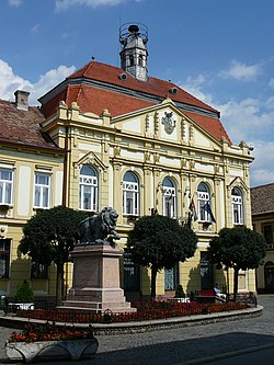 Town hall of Szigetvár
 Bell tower on the Mecsek Mountains
 Crystal caves in Nagyharsány
_19.jpg)
_2.jpg)

.jpg)


Notes
- Mellár is a member of Dialogue. He ran as a joint candidate of the United for Hungary electoral alliance during the 2022 parliamentary election.
References
External links
Wikiwand - on
Seamless Wikipedia browsing. On steroids.
Remove ads