Top Qs
Timeline
Chat
Perspective
Chilean Sea
Portion of the Pacific Ocean lying west of the Chilean mainland From Wikipedia, the free encyclopedia
Remove ads
The Chilean Sea is the portion of the Pacific Ocean lying west of the Chilean mainland. The official Chilean usage for Chilean Sea was defined on 30 May 1974 when the Diario oficial de la Republica de Chile published Supreme Decree #346, which declared that "the waters surrounding or touching the shores of the national territory shall be known as Mar Chileno."[1]
This article has multiple issues. Please help improve it or discuss these issues on the talk page. (Learn how and when to remove these messages)
|

The Chilean Sea contains significant amounts of phosphorite and manganese-iron nodules, which may be potential targets for future seafloor mining.[2]
Remove ads
Continental shelf and extended continental shelf
Summarize
Perspective
The continental shelf of Chile is the underwater extension adjacent to the Chilean coasts that stretches from the shoreline to the edge of the continental shelf in the Pacific Ocean and the Southern Ocean.[3][4]
The scientific study and delimitation of the continental shelf and its outer limit are conducted by the National Committee for the Continental Shelf, established in 2007.[5][6]
The delimitation of Chile's continental shelf follows principles established by the United Nations Convention on the Law of the Sea (UNCLOS), which sets guidelines for the delineation of continental shelves by coastal states. Chile has submitted claims to the United Nations Commission on the Limits of the Continental Shelf.
Apart from its economic importance, the continental shelf also holds geopolitical significance. Its delimitation has occasionally led to tensions with neighboring countries, particularly Argentina, which also claims rights over adjacent maritime areas.[7][8][9][10][11] Decisions and presentations made to the UN have influenced bilateral relations and Chile's maritime policies, making the continental shelf a critical issue in the country's security and defense agenda.Remove ads
Presential sea

The face sea, or heritage safeguard sea, is the maritime space that a certain coastal country demarcates, after an oceanopolitical appreciation, in order to indicate to third parties its zone of influence in the high seas adjacent to its exclusive economic zone, where its interests were or could be directly involved.
Without claims of sovereignty, by making a delimitation that includes the effective occupation of the high seas contiguous to its respective oceanic territory, the coastal state shows the interest in preserving said area from abusive uses or from certain activities that, due to its proximity, may affect the marine resources that inhabit its waters, especially, guarding the highly migratory straddling fishery resources from predation, and pollution of the marine habitat.
Remove ads
EEZ of Chile

Chile's EEZ includes areas around the Desventuradas Islands, Easter Island and the Juan Fernández Islands.
Gallery
 The Ferdinand Magellan's Nao Replica in the Museo Nao Victoria in Punta Arenas Chile, the first ship to sail it
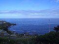 The Chilean Sea


See also
- Borde costero
- Maritime history of Chile
- Continental shelf of Chile
- Insular Chile
- Islands of Chile
- Tricontinental Chile
- Chilean Antarctic Territory
- Geography of Chile
- Chilean–Peruvian maritime dispute
- Pacific Islands Forum
- Easter Island
- Exclusive economic zone of Chile
- Presential Sea
- Mar de Grau
- Movimiento Archipiélago Soberano
- Norwegian Sea
- Libyan Sea
- List of active separatist movements in South America
- Chiloé Province
- Patagonia
- Arica y Parinacota Region
- Easter Island
Remove ads
References
Wikiwand - on
Seamless Wikipedia browsing. On steroids.
Remove ads