Top Qs
Timeline
Chat
Perspective
Cloudripper
Mountain peak of the Sierra Nevada in California, United States From Wikipedia, the free encyclopedia

Remove ads
Cloudripper is a 13,525-foot-elevation (4,122-meter) mountain summit located two miles east of the crest of the Sierra Nevada mountain range in Inyo County of northern California, United States.[3] It is situated in the Palisades area of the John Muir Wilderness, on land managed by Inyo National Forest. It is approximately 14 miles (23 km) west of the community of Big Pine, 1.1 miles (1.8 km) north-northeast of Picture Puzzle, and 2.1 miles (3.4 km) south of parent Mount Agassiz. Cloudripper ranks as the 58th highest summit in California,[2] and the highest point of the Inconsolable Range.[1]


Remove ads
Climbing
Established climbing routes on Cloudripper:[4]
- East Ridge via Big Pine Lakes – class 1
- North Ridge via Green Lake – class 2
- West Chute via Chocolate Lake – class 3[5]
The first ascent of the summit was made June 15, 1927, by Norman Clyde, who is credited with 130 first ascents, most of which were in the Sierra Nevada.[4][6] Other sources place the date as June 15, 1926.[7][8]
Climate
According to the Köppen climate classification system, Cloudripper is located in an alpine climate zone.[9] Most weather fronts originate in the Pacific Ocean, and travel east toward the Sierra Nevada mountains. As fronts approach, they are forced upward by the peaks, causing them to drop their moisture in the form of rain or snowfall onto the range (orographic lift). Precipitation runoff from this mountain drains east into North Fork Big Pine Creek, and northwest into headwaters of Bishop Creek.
Remove ads
Gallery
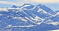 Cloudripper in winter
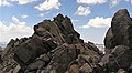 Cloudripper's summit
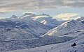


See also
References
External links
Wikiwand - on
Seamless Wikipedia browsing. On steroids.
Remove ads