Top Qs
Timeline
Chat
Perspective
Ferns Nipple
Summit in the state of Utah, U.S.A. From Wikipedia, the free encyclopedia

Remove ads
Ferns Nipple is a 7,065-foot (2,153-meter) elevation summit located in Capitol Reef National Park, in Wayne County of Utah, United States.[3] This iconic landmark is situated four miles (6.4 km) southeast of the park's visitor center. Precipitation runoff from this feature is drained by tributaries of the Fremont River, which in turn is within the Colorado River drainage basin. Folklore attributes this geological feature's naming to outlaw Butch Cassidy and his favored girlfriend named Fern.[4]


Remove ads
Climate
According to the Köppen climate classification system, it is located in a Cold semi-arid climate zone, which is defined by the coldest month having an average mean temperature below 32 °F (0 °C), and at least 50% of the total annual precipitation being received during the spring and summer. This desert climate receives less than 10 inches (250 millimeters) of annual rainfall, and snowfall is generally light during the winter.
Remove ads
Geology
Ferns Nipple is composed of Navajo Sandstone, which is believed to have formed about 180 million years ago as a giant sand sea, the largest in Earth's history.[5] In a hot, dry climate, wind blew over sand dunes, creating large, sweeping crossbeds which date to the Jurassic. Long after the sedimentary rocks were deposited, the Colorado Plateau was uplifted relatively evenly, keeping the layers roughly horizontal, but Capitol Reef is an exception because of the Waterpocket Fold, a classic monocline, which formed between 50 and 70 million years ago during the Laramide Orogeny.[6]
Remove ads
Gallery
 Ferns Nipple from west
 Ferns Nipple from west
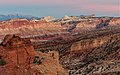 Ferns Nipple in the distance


See also
References
External links
Wikiwand - on
Seamless Wikipedia browsing. On steroids.
Remove ads