Top Qs
Timeline
Chat
Perspective
Finger of Fate (Idaho)
Pillar in Custer County, Idaho, United States From Wikipedia, the free encyclopedia

Remove ads
Finger of Fate is a 9,780-foot-elevation (2,981 m) pillar in Custer County, Idaho, United States.
.jpg)


Remove ads
Description
Finger of Fate is a distinctive landmark and rock-climbing destination in the Sawtooth Range which is a subrange of the Rocky Mountains.[1][5] It is situated 13 miles (21 km) south of Stanley, Idaho, in the Sawtooth Wilderness on land managed by Sawtooth National Forest.[5] The spire can be seen from Highway 75 at Galena Summit as travelers approach Sawtooth Valley.[6] Precipitation runoff from the mountain drains to Hell Roaring Lake, thence the Salmon River via Hell Roaring Creek. Topographic relief is significant as the summit rises nearly 2,400 feet (732 meters) above the lake in one mile (1.6 km). The first ascent of the summit was made in 1958 by Louis Stur and Jerry Fuller via The Open Book (class 5.8).[1] A 6.5 magnitude earthquake in 2020 dislodged the summit boulder from the top of the pillar.[1] This landform's descriptive toponym has been officially adopted by the United States Board on Geographic Names.[3]
Remove ads
Climate
Based on the Köppen climate classification, Finger of Fate is located in an alpine subarctic climate zone with long, cold, snowy winters, and cool to warm summers.[7] Winter temperatures can drop below 0 °F with wind chill factors below −10 °F. Climbers can expect afternoon rain and lightning from summer thunderstorms.
Climbing chronology
History of early first ascents:[1]
See also
Gallery
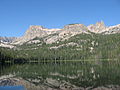 Hell Roaring Lake with Finger of Fate to the right
 Hell Roaring Lake with Finger of Fate to the right
 Hell Roaring Lake with Finger of Fate centered on skyline
 Hell Roaring Lake with Finger of Fate to right


References
External links
Wikiwand - on
Seamless Wikipedia browsing. On steroids.
Remove ads