Top Qs
Timeline
Chat
Perspective
Ipsoot Mountain
Glaciated summit in southwest British Columbia, Canada From Wikipedia, the free encyclopedia

Remove ads
Ipsoot Mountain is a 2,576-metre (8,451-foot) glaciated summit located in southwest British Columbia, Canada.


Remove ads
Description
Ipsoot Mountain is situated in the Coast Mountains, 13 km (8 mi) west of Pemberton and 22 km (14 mi) north of Whistler. Precipitation runoff and glacial meltwater from this large mountain drains into Pemberton, Miller and Rutherford creeks, then eventually Lillooet River. Ipsoot is more notable for its steep rise above local terrain than for its absolute elevation as topographic relief is significant with the summit rising over 1,800 meters (5,900 ft) above Rutherford Creek in approximately 4 km (2.5 mi). The mountain was named by the first ascent party, and "ipsoot" means "hidden", or "to hide" in Chinook Jargon, as this peak is indeed hidden from view in adjacent valleys.[5][6] The toponym was officially adopted June 22, 1967, by the Geographical Names Board of Canada.[3]
Remove ads
Climate
Based on the Köppen climate classification, Ipsoot Mountain is located in the marine west coast climate zone of western North America.[7] Most weather fronts originate in the Pacific Ocean, and travel east toward the Coast Mountains where they are forced upward by the range (Orographic lift), causing them to drop their moisture in the form of rain or snowfall. As a result, the Coast Mountains experience high precipitation, especially during the winter months in the form of snowfall. Winter temperatures can drop below −20 °C with wind chill factors below −30 °C. This climate supports the Ipsoot Glacier (also known as the Ipsoot Icefield) on the peak's northwest slope.[8] The months July through September offer the most favorable weather for climbing Ipsoot Mountain.
Remove ads
See also
Gallery
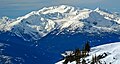 East aspect, viewed from Mt. Taylor
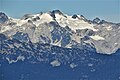 South aspect of Ipsoot Mountain viewed from Whistler Mountain
 South aspect, viewed from Rainbow Mountain in winter
 South aspect, viewed from Rainbow Mountain


References
External links
Wikiwand - on
Seamless Wikipedia browsing. On steroids.
Remove ads