Top Qs
Timeline
Chat
Perspective
Kai Tak Nullah
Watercourse in Kowloon, Hong Kong From Wikipedia, the free encyclopedia
Remove ads
The Kai Tak Nullah (Chinese: 啟德明渠), also known as the Kai Tak River (啟德河) and sometimes spelled Kaitak, is a nullah or watercourse that collects water from the rivers and streams flowing from the hills in northern New Kowloon. It empties into a narrow channel leading into the Kwun Tong Typhoon Shelter. Part of the nullah is covered by roads and other facilities.

The Kai Tak Nullah is about 2.4 km (1.5 mi) in length. It flows from Po Kong Village Road along Choi Hung Road, pass Tung Tau Estate and San Po Kong, into Kai Tak Development Area before discharging into the Victoria Harbour at the Kwun Tong Typhoon Shelter. It has an upstream and a midstream. The nullah is one of the major flood relief drainage channels in the East Kowloon area.[1] The improvement work of Kai Tak Nullah has been overseen by the Civil Engineering and Development Department since March 2012, aiming to turn the nullah into an attractive green river corridor.[2] It was anticipated to be fully completed before 2021.
Remove ads
History
Summarize
Perspective
Originally, the location of Kai Tak Nullah was a bay. During Japanese occupation, Kai Tak Airport was expanded through land reclamation. The extension of Fung Wong Kai Stream was named Lung Tsun River (龍津河). Lung Tsun River's original estuary is at the north of To Kwa Wan Road. After the airport expansion work,[when?] however, reclamation for the runway blocked the estuary, and the river was redirected to follow today's route.[clarification needed][citation needed]
During New Territories' new town development in the 1970s, the river become a nullah for Tai Po Sewage Treatment Works, Sha Tin Sewage Treatment Works and illegal discharge pollutants. This resulted in pollutants and heavy pollutants being in the water, which resulted in the waterway giving off a putrid smell. After treatment work by the Drainage Services Department in 2000, Kai Tak Nullah has seen significant improvement. Herons are occasionally now seen along the nullah.
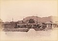 Kai Tak Nullah was a bay, close to Lung Tsun Stone Bridge (1915)
 Map of Kowloon in 1915. The Kai Tak Nullah is next to Kowloon Walled City (or Chinese Town in this map) and Lung Tsun Stone Bridge.
 Kai Tak Nullah in 1960
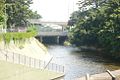 Water flow from Nullah to Kai Tak Airport in 2007
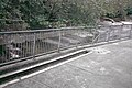 Meeting point of Fung Wong Kai Stream and Kai Tak Nullah (2008)


Remove ads
Proposal of covering nullahs

In January 2005, the Drainage Services Department announced plans for nullah-covering works for 16 nullahs, at the cost of 1.2 billion Hong Kong dollars. These included a plan to cover up part of the Kai Tak Nullah along Choi Hung Road, starting in 2010 and finishing by 2014. The Traffic and Transport Committee of Wong Tai Sin District Council demanded a faster timetable, in order to launch the greening work and widen Choi Hung Road.
As the water quality improved, at the urging of the pro-Beijing political party Democratic Alliance for the Betterment and Progress, the Federation of Trade Unions, and environment concern group Conservancy Association, the Civil Engineering and Development Department launched a feasibility study on turning the nullah into Kai Tak River.[3][4] They aim to turn it into a new river like the Cheonggyecheon in South Korea.[5]
Remove ads
See also
Wikimedia Commons has media related to Kai Tak Nullah.
References
Wikiwand - on
Seamless Wikipedia browsing. On steroids.
Remove ads