"Nuestra Señora de La Paz" redirects here. For the sector of Santo Domingo, Dominican Republic, see Nuestra Señora de la Paz.
La Paz (Spanish:[laˈpas]; lit.'the peace'), officially Nuestra Señora de La Paz (Aymara:Chuqi YapuAymara pronunciation:[ˈtʃoqɛˈjapʊ]), is the seat of government of Bolivia. With 755,732 residents as of 2024,[6][7] it is the third-most populous city in Bolivia. Its metropolitan area, which includes the neighboring city of El Alto, and other smaller towns, is the second most populous urban area in Bolivia, with a population of 2.2million, after Santa Cruz de la Sierra with a population of 2.3million.[7] The city is also the capital of the department of the same name.
Los discordes en concordia, en paz y amor se juntaron y pueblo de paz fundaron para perpetua memoria. ("The dissenters in harmony gathered together in peace and love, and a town of peace they founded, for perpetual memory.")[1]
Located in west-central Bolivia 68km (42mi) southeast of Lake Titicaca, La Paz is set in a canyon created by the Choqueyapu River. It is in a bowl-like depression, part of the Amazon basin, surrounded by the high mountains of the Altiplano. Overlooking the city is the triple-peaked Illimani. Its peaks are always snow-covered and can be seen from many parts of the city. At an elevation of roughly 3,650m (11,975ft)above sea level, La Paz is the highest administrative capital city in the world.[8][9] Due to its altitude, the city has an unusual subtropical highland climate, with rainy summers and dry winters.
La Paz was founded on 20 October 1548, by the Spanish conquistador Captain Alonso de Mendoza, at the site of the Inca settlement of Laja as a connecting point between the commercial routes that led from Potosí and Oruro to Lima; the full name of the city was originally Nuestra Señora de La Paz (meaning Our Lady of Peace) in commemoration of the restoration of peace following the insurrection of Gonzalo Pizarro and fellow conquistadors against the first viceroy of Peru. The city was later moved to its present location in the valley of Chuquiago Marka.[10] La Paz was under Spanish colonial rule as part of the Viceroyalty of the Río de la Plata, before Bolivia gained independence. Since its founding, the city was the site of numerous revolts. In 1781, the indigenous leader and independence activist Túpac Katari laid siege to the city for a total of six months, but was finally defeated. On 16 July 1809, the Bolivian patriot Pedro Domingo Murillo ignited a revolution for independence, marking the beginning of the Spanish American Wars of Independence, which gained the freedom of South American states in 1821.[11]
As the seat of the government of Bolivia, La Paz is the site of the Palacio Quemado, the presidential palace. It is also the seat of the Bolivian legislature, the Plurinational Legislative Assembly, and numerous government departments and agencies. The constitutional capital of Bolivia, Sucre, retains the judicial power.[12] The city hosts all the foreign embassies as well as international missions in the country. La Paz is an important political, administrative, economic, and sports center of Bolivia; it generates 24% of the nation's gross domestic product and serves as the headquarters for numerous Bolivian companies and industries.[13]
Calle Jaén in the historic center of La Paz, contains well-preserved Spanish Colonial buildings.
The Spanish conquistadors founded the city in 1548 with the name Nuestra Señora de La Paz (meaning Our Lady of Peace). The name commemorated the restoration of peace following the insurrection of Gonzalo Pizarro and fellow conquistadors four years earlier against Blasco Núñez Vela, the first viceroy of Peru.[17]
In 1825, after the decisive victory of the republicans at Ayacucho over the Spanish army in the course of the Spanish American wars of independence, the city's full name was changed to La Paz de Ayacucho (meaning The Peace of Ayacucho).
The region in which La Paz is located in was known as Chuquiago Marka (marka means village;[18]Chuqi Yapu means 'gold farm', probably due to the exploitation of gold nuggets in the small rivers of the place;[19] spelling differences due to Aymara writing compared to Spanish transliteration) in the Aymara language, leading former President of BoliviaEvo Morales to suggest renaming the city to "Chuquiago Marka" in a speech in 2017.[20][21]
This area had been the site of an Inca city on a major trading route.
Although the Spanishconquistadors entered the area in 1535, they did not find La Paz until 1548. Originally it was to be at the site of the Native American settlement, Laja. The town site was moved a few days later to its present location in the valley of Chuquiago, which is more clement.[17]
Control over the former Inca lands had been entrusted to Pedro de la Gasca by the Spanish king (and Holy Roman Emperor) Emperor Charles V. Gasca commanded Alonso de Mendoza to found a new city commemorating the end of the civil wars in Peru; the city of La Paz was founded on 20 October 1548, by Alonzo de Mendoza, with Juan de Vargas appointed as its first mayor.[22]
In 1549, Juan Gutierrez Paniagua was commanded to design an urban plan that would designate sites for public areas, plazas, official buildings, and a cathedral. These were meant to express the ideals and relationships of Spanish colonial society.[citation needed] La Plaza de los Españoles, which is known today as the Plaza Murillo, was chosen as the location for government buildings as well as the Metropolitan Cathedral.[citation needed]
Spain controlled La Paz with a firm grip and the Spanish king had the last word in all matters political, but consultation was extended, taking months or longer by sea. Indigenous and other unrest was repeated around the turn of the nineteenth century.[citation needed] In 1781, for a total of six months, a group of Aymara people laid siege to La Paz. Under the leadership of Tupac Katari, they destroyed churches and government property. Thirty years later Indians conducted a two-month siege against La Paz. This incident was the setting for the origin of the legend of the Ekeko. In 1809, the struggle for independence from the Spanish rule brought uprisings against the royalist forces.[citation needed] On 16 July 1809, Pedro Domingo Murillo said that the Bolivian revolution was igniting a lamp that nobody would be able to turn off. This uprising formally marked the beginning of the liberation of South America from Spain. The first open rebellions against the Spanish Crown took place in La Paz and the city of Sucre simultaneously.[citation needed] This event is known as the Primer Grito Libertario de América and brought about the Bolivian War of Independence.
Pedro Domingo Murillo was hanged at the Plaza de los Españoles several months later, on 29 January 1810.[citation needed] After Bolivia gained independence, La Paz named this plaza after him, to commemorate him always. He is remembered as the voice of revolution across South America.
In 1898, La Paz was made the de facto seat of the national government, with Sucre remaining the nominal historical as well as judiciary capital. This change reflected the shift of the Bolivian economy away from the largely exhausted silvermines of Potosí to the exploitation of tin near Oruro, and resulting shifts in the distribution of economic and political power among various national elites.[23]
The segregation of Cholitas (women of Andean indigenous background) continued until the 1980s. They were not allowed to enter certain public places and were banned from cinemas and some restaurants, with more emphasis in Bolivian eastern cities like Santa Cruz De La Sierra.[24]
Remove ads
Geography
Summarize
Perspective
La Paz is characterized by its mountainous geography, the snow-capped Illimani dominates the city's skyline
La Paz is built in a canyon created by the Choqueyapu River (now mostly built over), which runs northwest to southeast. The city's main thoroughfare, which roughly follows the river, changes names over its length, but the central tree-lined section running through the downtown core is called the Prado.
The geography of La Paz (in particular the altitude) is marked by social differences. The more affluent residents live in the lower, central areas of the city southwest of the Prado. Many middle-class residents live in high-rise condos near the center. Lower-income residents live in makeshift brick houses in the surrounding hills. The satellite city of El Alto, where the airport is, is spread over a broad area to the west of the canyon, on the Altiplano.
An earthquake in July 1994 rated at 8.2 struck 200 miles (322km) north of La Paz. It could be felt near La Paz and caused damage throughout the villages of the area. In February 2002 the city was subjected to a hail and rainstorm that resulted in flooding causing serious damage and over 50 deaths.[25]
Climate
Due to its geographical location and altitude, La Paz has an unusual climate with rainy summers, dry winters and little temperature seasonality
At more than 4,000 meters (13,000ft) above sea level, higher parts of La Paz have a cold subtropical highland climate (Köppen: Cwc), bordering on a tundra climate (Köppen: ET).[26] At this altitude, night-time temperatures range from cold to very cold. Snow flurries can occur in winter, especially at dawn and usually melts before noon. Despite being located only 16 degrees from the equator, this part of the city has average temperatures similar to that of cities such as Bergen, Norway or Tórshavn, Faroe Islands.
Temperatures in central La Paz, at 3,600 meters (11,811 feet), and in the Zona Sur (Southern Zone), at 3,250m (10,663ft) above sea level are warmer and are classified as subtropical highland climate (Köppen: Cwb).[26] Heavy precipitation typically occurs throughout summer, and often causes destructive mudslides. At an altitude of 3,250 meters, in the southern part of the city, the wettest month is January with a monthly average of 114mm (4.5in), and the driest is July with 8mm (0.3in).
The whole city has rainy summers and dry winters. The city has a relatively dry climate, with rainfall occurring mainly in the slightly warmer months of November to March. Heavy precipitation typically occurs throughout summer, and often causes destructive mudslides. The wettest month is January with a monthly average of 100–140mm (3.9–5.5in) of precipitation, and the driest months are June and July with around 5mm (0.2in) of precipitation.
In the highest part of the city, above 4,000 meters, the two cloudiest months are February and March, in late summer, when sunshine averages around 5 hours per day. The two sunniest months are June and July, in winter, when sunshine averages around 8 hours per day.[27]
More information Climate data for El Alto, Bolivia (El Alto International Airport), elevation 4,058 m (13,314 ft), (1991–2020 normals, extremes 1942–present), Month ...
Aerial view of San Jorge in the Cotahuma districtLocated in the district known as Cotahuma and near Sopocachi, is one of the main residential and diplomatic areas of the city. San Jorge was one of the most exclusive neighborhoods of La Paz and the financial center of the metropolis, housing international firms like Deloitte, Bank of America, Ernst & Young, BBVA and the famous Ritz Hotel. It is now home of some of Bolivia's tallest building known as Torre Girasoles, Torres del Poeta, and the only intelligent building of the country, known as Torre Azul. The neighborhood is also populated with expensive offices, renowned restaurants, museums and bookstores. Its Avenida Arce, one of the main streets of the city, is the highest-priced street in the country and the one with the most upscale boutiques in Bolivia. San Jorge is home to the embassies of the United States, the United Kingdom, Brazil, Japan, Germany and Spain. The offices of the World Bank, the Inter-American Development Bank, the CAF – Development Bank of Latin America and the Caribbean, the Goethe Institut, the Alliance Française and the Dante Alighieri Society are also located in this modern neighborhood.
Plaza Abaroa in the neighborhood of Sopocachi.Located in the 1st District (Cotahuma), Sopocachi is probably one of the oldest residential neighborhoods, 10 minutes from the center of the city. Despite the expansion and development of the area, this quarter maintained its residential property. In the last years, there has been an important commercial expansion, mainly on the surroundings of Abaroa Square, one of the many squares and parks of the zone.
San Pedro
Located in the 1st District (Cotahuma), on the right bank of the Choqueyapu River and built around the "Plaza de San Pedro" (official name: Plaza Sucre, Sucre Square), is home to numerous shops, businesses and small enterprises, especially printing, spare parts and auto maintenance and repair shops. San Pedro's "Rodriguez Market" remains as one of the most popular middle-class and oldest of the city. The San Pedro prison is here.
Centro
The Basilica of San Francisco in the city centerThe city's downtown area, in the 7th District, comprising the center of La Paz and principal roads of the city, like Arce Avenue, 16 July Avenue (also known as "Prado Avenue"), Mariscal Santa Cruz Avenue and Camacho Avenue – the last one being the home of the headquarters of the principal banks and companies of the country.
Casco Viejo
Located in the 7th District, is the historic and ancient center of La Paz. It now houses museums, hotels, shops and buildings as the Mayor City of La Paz and the Central Bank of Bolivia. In the Old Quarter is the Plaza Murillo, which is home to the Government Palace and the National Congress.
Miraflores
The Paseo del Prado, one of the main throughfares in the cityIn the 7th District, Miraflores district is separated from downtown by a long barrel (Parque Urbano Central, "Central Urban Park") and connected by the Bridge of the Americas and two avenues. Originally a residential zone, its growth has led it to become a major recreational center. It houses universities (including the Universidad Mayor de San Andrés's faculty of medicine), hospitals and the Estadio Hernando Siles (capacity of 45,000 people).
Northern District
Located in the 2nd and 3rd districts, it has a significant industrial activity (mainly food), being the Cervecería Boliviana Nacional (Bolivian National Brewery) the most significant industry founded by Germans, and one of the city's biggest companies in the country. It connects La Paz with the city of El Alto by the autopista (highway).
Southern District
View of Calacoto in the Southern districtIn the 5th district; has less height than the rest of La Paz (3,200 to 2,800 meters). It is referenced as the "Macrodistrito Sur" which has 3 districts with an area of 47.8 km2. The population density reached 3,084 inhabitants per squared km. in 2016. Obrajes, Bolognia, Koani, Achumani, San Miguel, Cota Cota, Irpavi, Següencoma, Ovejuyo, Chasquipampa, La Florida and Calacoto are some neighborhoods that make it up. This city district is the area of greatest expansion and growth, both population and the construction sector in La Paz.[32] This area houses some of the most affluent and exclusive neighborhoods of the city. It has been benefited from steady economic growth and is now the second commercial and financial center of the city, housing international firms like Moody's, Citibank, Aon Corporation, Huawei, Millicom International Cellular, Nissan Motor Corporation, Samsung Electronics, Pan American Silver Corporation, a Sumitomo Corporation branch, Ernst & Young, and the "MegaCenter", La Paz's biggest shopping mall.
Remove ads
Cityscape
Panorama of La Paz at sunset, from the "Killi Killi" lookout.
Colonial architecture
The city of La Paz has a consistently decreasing volume of colonial buildings, mostly centered around the vicinity of the Plaza Murillo.[33] Due to a lack of funds and the inability of property owners to pay for restorations to colonial buildings, many have been torn down, or are in a dilapidated state. As historic buildings are more expensive to keep, land owners find it less of a burden to construct more modern buildings as opposed to keeping the old ones. Although there has been an increasing number of projects and propositions to restore some of the city's colonial buildings, the future of these historic edifices remains uncertain.
The economy of La Paz has improved greatly in recent years, mainly as a result of improved political stability. Due to the long period of high inflation and economic struggle faced by Bolivians in the 1980s and early 1990s, a large informal economy developed. Evidence of this is provided by the markets found all around the city.
While there are stable markets, almost every street in the downtown area and surrounding neighborhoods has at least one vendor on it.[34]
La Paz remains the principal center of manufacturing enterprises that produce finished-product goods for the country, with about two-thirds of Bolivia's manufacturing located nearby.[35] Historically, industry in Bolivia has been dominated by mineral processing and the preparation of agricultural products. However, in the urban center of La Paz, small plants carry out a large portion of the industry. Food, tobacco products, clothing, various consumer goods, building materials, and agricultural tools are produced. "The tin quotations from London are watched in La Paz with close interest as an index of the country's prosperity; a third of the national revenue and more than half of the total customs in 1925 were derived from tin; in short, that humble but indispensable metal is the hub around which Bolivia's economic life revolves. The tin deposits of Bolivia, second largest in the world, ... invite development."
La Paz is the home of some of the biggest football teams in Bolivia.
Club Bolívar: Founded in 1925, it was named in honor of the Libertador Simón Bolívar, the team has won most of the tournaments national and international championships in the last 20 years, and is the largest team, by number of fans, of the country. The year 1964 was a bad year, as it was relegated from the top division, playing the next year in the second division. But it soon returned to the top flight.
The Strongest: Founded in 1908 the club hosts some of its games and trains on their home stadium named Rafael Mendoza after Don Rafael Mendoza, one of the most important presidents of the club. In 1968 an airplane accident took the life of almost all the players, but Rafael Mendoza made many efforts that allowed the team to rise again as one of the most important in the country.
La Paz F.C.: Founded in 1989, the club quickly rose through the ranks to become the third major club in the capital, only behind in popularity to the two well-established city rivals.
The city is host to several other teams that play in the first and second divisions such as:
With the exception of Deportivo Municipal and Unión Maestranza, all the other teams play the majority of their games in the city stadium, the Estadio Hernando Siles, which also hosts the national football team and international games. Always Ready frequently play at the Estadio Rafael Mendoza which belongs to The Strongest, who rarely use the stadium due to its relatively small capacity.
Remove ads
Education
The city hosts some of the most important universities of the country:
The Witches' Market in the city center, a popular spot for tourists
La Paz is an important cultural center of Bolivia. The city hosts several cathedrals belonging to the colonial times, such as the San Francisco Cathedral and the Metropolitan Cathedral, this last one located on Murillo Square, which is also home of the political and administrative power of the country. Hundreds of different museums can be found across the city, the most notable ones on Jaén Street, which street design has been preserved from the Spanish days and is home of 10 different museums.
The home of the Bolivian government is located on Murillo Square and is known as "Palacio Quemado" (Burnt Palace) as it has been on fire several times. The palace has been restored many times since, but the name has remained untouched.
Principal attractions
Museums and cultural centers
Local shops along Linares Street, a popular tourist spot in the city center
The former home of Pedro Domingo Murillo, martyr of the independence revolution of 1809, has been preserved and is now a museum. The house displays a collection of furniture, textiles, and art from colonial times.
Museo Costumbrista: Displays ceramic dolls wearing traditional customs that show how was life in the early 19th century. Also on display are photos of old La Paz.
Museo Nacional de Arqueología (National Museum of Archeology): Depicts a collection of artifacts of the Tiawanaku culture.
Museo del Litoral (Museum of the Litoral Coastal Region): Displays objects from the 1879 war in which Bolivia lost its sea coast to Chile.
Museo del Oro (Gold Museum): Depicts pre-Conquest works made of gold, silver and copper.
Museo de Etnografía y Folklore (Ethnography and Folkolore Museum): Located in a house built during the late 18th century, it exhibits customs and art of two ethnic groups: Chipayas and Ayoreos.
Museo del Charango (Museum of Charango): Located in Calle Linares, the museum displays an important variety of charangos. Other native instruments are displayed as well.
Museo de Historia Natural (Natural History Museum): Exhibits on Bolivian paleontology, geology, zoology and botanical elements of interest.
Casa Museo Marina Nuñez del Prado (Marina Nuñez del Prado House Museum): Displays Quechua and Aymara-theme sculptures by Bolivian artist Marina Nuñez del Prado.Cathedral Basilica of Our Lady of Peace Erected in 1835.
Museo Nacional de Arte (National Art Museum): Located in Calle Comercio, on a former palace built in 1775, displays works by Melchor Perez de Holguín and Marina Nuñez del Prado, among others.
Mercado de Brujas (Witches' Market): Merchandise sold here includes herbs, remedies as well as other ingredients used in Aymara traditions.
Feria de Alasitas: This fair is celebrated for two weeks each year, beginning 24 January. The central figure is a little god of abundance known as Ekeko, which means dwarf in Aymara.
Geological formations in the "Valle de las Ánimas" on the outskirts of the city
Remove ads
Culture
Summarize
Perspective
La Paz has established itself as one of the main cultural, historical, and political centers of the country. Its unique geography, nestled in an Andean valley at more than 3,600 meters above sea level, has shaped not only its urban development but also the cultural identity of its inhabitants. Over the centuries, La Paz has functioned as a meeting point between Andean traditions, colonial expressions, and modern dynamics. The city has developed a diverse network of institutions, practices, and artistic expressions. Its museums, such as the National Museum of Art and the Museum of Ethnography and Folklore, are repositories of a heritage that ranges from pre-Columbian pieces to contemporary manifestations. Likewise, festivities such as the Gran Poder procession—declared Intangible Cultural Heritage of Humanity by UNESCO in 2019—highlight the vitality of La Paz’s popular traditions and their ability to integrate Indigenous, mestizo, and modern elements into a single celebration.[38]
Several fairs and cultural events are held annually. Each year, the majestic Gran Poder procession is celebrated, bringing together many people from all over the country and abroad. It is a folkloric parade showcasing Bolivia’s diverse dances, where mestizaje predominates within these traditional dances. Much of the cultural life is organized by the local municipality or by the central government. On the El Prado boulevard, the “Sunday Fair” (Feria Dominical) is held to provide space for artists and different types of exhibitors who gather and offer various performances aimed at relieving the congestion of the city center with a relaxed, family-oriented artistic atmosphere.
As the seat of government and home to the main leaders of Bolivia’s independence revolution, La Paz hosts most of the country’s historical museums. Museums, art galleries, and cultural centers are largely supported by state funding and, in other cases, by private institutions.
Most museums are located in the historic center of the city, occupying the old buildings on Jaén Street. This area preserves much of the urban layout inherited from the colonial period and is currently home to around ten museums.[39]
Among them is the National Museum of Art, located in the former Diez de Medina Palace, a colonial-era building dating back to the 18th century. This museum houses one of the most important collections in the country, with works ranging from the viceregal period to contemporary Bolivian art, making it a key reference point for the study of visual arts in Bolivia.
Also notable is the National Museum of Ethnography and Folklore (MUSEF), which safeguards a vast collection of pieces linked to Bolivia’s Indigenous cultures. Its collections include textiles, ceramics, masks, and ritual objects that document the country’s cultural diversity. The museum plays a fundamental role in research and preservation of intangible heritage, in addition to serving as a space for academic and cultural dissemination.
The former home of Pedro Domingo Murillo, martyr of the independence revolution of 1809, has been preserved and is now a museum. The house displays a collection of furniture, textiles, and art from colonial times.
Museo Costumbrista: Displays ceramic dolls wearing traditional customs that show how was life in the early 19th century. Also on display are photos of old La Paz.
Museo Nacional de Arqueología (National Museum of Archeology): Depicts a collection of artifacts of the Tiawanaku culture.
Museo del Litoral (Museum of the Litoral Coastal Region): Displays objects from the 1879 war in which Bolivia lost its sea coast to Chile.
Museo del Oro (Gold Museum): Depicts pre-Conquest works made of gold, silver and copper.
Museo de Etnografía y Folklore (Ethnography and Folkolore Museum): Located in a house built during the late 18th century, it exhibits customs and art of two ethnic groups: Chipayas and Ayoreos.
Museo del Charango (Museum of Charango): Located in Calle Linares, the museum displays an important variety of charangos. Other native instruments are displayed as well.
Museo de Historia Natural (Natural History Museum): Exhibits on Bolivian paleontology, geology, zoology and botanical elements of interest.
Casa Museo Marina Nuñez del Prado (Marina Nuñez del Prado House Museum): Displays Quechua and Aymara-theme sculptures by Bolivian artist Marina Nuñez del Prado.
Museo Nacional de Arte (National Art Museum): Located in Calle Comercio, on a former palace built in 1775, displays works by Melchor Perez de Holguín and Marina Nuñez del Prado, among others.
Mercado de Brujas (Witches' Market): Merchandise sold here includes herbs, remedies as well as other ingredients used in Aymara traditions.
Feria de Alasitas: This fair is celebrated for two weeks each year, beginning 24 January. The central figure is a little god of abundance known as Ekeko, which means dwarf in Aymara.
In La Paz, handicrafts are an essential part of both the local (paceña) and Bolivian culture. In the city of La Paz, one can find a wide variety of handcrafted items at fair prices: decorative objects, clothing accessories, garments, souvenirs, and much more—often made by artisan collectives, which are generally composed of entire families who have found in this craft a source of income. In this way, thousands of Bolivian family groups sustain themselves day by day through artisanal work.
Gastronomy
Traditional plato paceño consisting of lima beans, potatoes, white corn and fried cheese.
The gastronomy of La Paz is diverse and complete, and it continues to evolve, becoming increasingly cosmopolitan and more sophisticated in both local and international cuisine.[40] The city offers a wide range of food options, from the most traditional, rustic, and community-based dishes, to varieties representing all departments of Bolivia, as well as fusion cuisine and restaurants serving Latin American, Asian, and European food.[41]
Street food is very popular in La Paz. Well-known dishes include salteña, tucumanas, papa rellena, choripán, anticucho, and the sándwich de chola.[42] All of this led Netflix to feature La Paz in the series 'Street Food: Latin America'.[43]
Another popular food from La Paz includes marraqueta, plato paceño, fricasé, picante mixto, llaucha, ranga ranga, chairo, and silpancho
Textiles
Aguayos of various designs for sale in La Paz
The textile art of La Paz is one of the oldest textile traditions in the Andes and became one of the most developed during the height of the Inca Empire, due to the use of different materials and techniques—an outcome of its hybrid culture formed through the conquest of other Andean ethnic groups.
Paceño textiles are characterized by geometric designs (known as tocapus) and the fineness of their technique. The Incas, who once inhabited the entire region, were noted for their tapestries and feathered cloaks, also featuring geometric motifs. They had an extraordinary sense of symmetry, reflected in the repetition of stylized figures arranged in an extremely orderly fashion.[44]
An important factor in the textile production of the Altiplano region and the city of La Paz is the area’s dry and cold climate. For this reason, textile models and clothing in this part of the country were designed to withstand low temperatures; one of the most well-known garments for fulfilling this function is the poncho, of pre-Hispanic origin, which originally appeared under the name unku. It is essentially a piece of fabric with an opening in the middle for the head; the result is a warm and comfortable garment that covers most of the body, depending on the style.
Another element widely used in the creation of artisanal pieces is the aguayo, a typically Andean textile of pre-Columbian origin with immense cultural significance. Each textile has a story to tell: the weaves, colors, threads, and figures within it represent characters and experiences from the communities or their weavers.
Local festivals
The Alasitas yearly fair, where people buy miniature gifts and pray to the God of prosperity, Ekeko
January: Achocalla Festival: Occurs during the first week of January. The city of La Paz comes together to celebrate this religious festival with traditional dances, music, and a parade. In Bolivia's harvest calendar, Achocalla marks the time when potato fields begin to bloom. People dance the traditional folklore dance known as "tarqueada" during the festival.
24 January: Alasitas is a yearly fair where people buy miniature gifts and praise the god of prosperity, Ekeko. The fair begins every 24 January and lasts for a month. In 2017, it has been included into the Intangible Cultural World Heritage of UNESCO.[45]
3 May: Señor de la Santa Cruz (Calvario, Tacagua, Calacoto)
13 May: Virgen de Fátima (Villa Fátima)
14 May: San Isidro, Labrador (San Isidro)
17 May: Señor de la Sentencia (Villa Armonía)
May: Santísima Trinidad del Señor Jesús del Gran Poder (movible, Gran Poder) La Fiesta del Gran Poder occurs on Trinity Sunday. Therefore, it happens on different dates every year. But the festival typically occurs during late May to early June. This festival pays homage to El Señor del Gran Poder. During the festival, over 30,000 dancers take the streets of La Paz performing dances with themes that represent both Aymara folktales and Catholic traditions. The dancers wear colorful homemade costumes. The Parade lasts all day throughout the night. In 2019, it has been included into the Intangible Cultural World Heritage of UNESCO.
13 June: San Antonio de Padua (San Antonio)
24 June: San Juan Bautista (Valle Hermoso, San Juan)
29 June: San Pedro Apóstol (San Pedro)
16 July: Virgen del Carmen, Patroness of Bolivia and the Armed Forces of the Nation Efemerides of La Paz
25 July: Apóstol Santiago (Munaypata, Pampahasi, Pasankeri, Periférica, Alto Delicias)
15 August: Virgen de Urqupiña (Urkupiña)
15 August: Virgen de la Asunción (Villa Victoria)
8 September: Virgen de las Nieves (V. Copacabana, M. Paredes, La Portada, Achachicala, Alto Irpavi, Cotahuma, Las Nieves)
14 September: Señor de la Exaltación (Obrajes, G. de Lima, Bajo Tejar, Vino Tinto)
24 September: Virgen de la Merced (Cota Cota)
7 October: Virgen del Rosario (El Rosario)
November: Cristo Rey (Pura Pura)
4 December: Santa Barbara (Santa Bárbara, Llojeta)
8 December: Virgen de la Concepción (Kupini, Sopocachi, Achumani)
Remove ads
Transportation
Summarize
Perspective
Rush hour traffic on Mariscal Santa Cruz Avenue in the city center
Public transportation is the main means of transport for the people of La Paz. In La Paz, 81.9% of its residents move around the city using public transportation, whether fixed-route taxis (Trufis), minibuses, microbuses, or taxis.[46] There are around 300 organizations and unions associated with public transportation, whose fares have been regulated by the La Paz City Hall since 2003.
In the Municipality of La Paz, 241,827 vehicles were registered up to the year 2014, of which 19.3% were vehicles for public use.[47] According to the interurban mobility survey in La Paz, it was estimated that in 2014, more than one million people used the public transportation system available in the city in some way; of these, about 900,000 passed through or traveled to the Municipality of La Paz.
There are around 7.7 million weekly routes within La Paz and 9.7 million in the metropolitan area of La Paz, including the city of El Alto and other neighboring municipalities. The average travel time for the population in the urban region is around 30 minutes.[46] On the other hand, La Paz has the most expensive transportation service among the three main cities of Bolivia’s central axis, ahead of Santa Cruz de la Sierra and Cochabamba.[48]
Highways
The La Paz-El Alto Highway is a toll road that connects the city of La Paz with the neighboring city of El Alto. It is the city's main highway. It allows easy access to El Alto International Airport. The highway runs 11,7km and crosses the city of El Alto:
The main toll of the La Paz - El Alto highway connects both neighboring cities
Autopista La Paz-El Alto/RN-3 (La Paz-El Alto Highway) – Connects La Paz with El Alto.
Autovía La Paz Oruro/A-1 (La Paz-Oruro Highway) – Connects La Paz with the cities of Oruro, Patacamaya and Caracollo. It then connects with Ruta Nacional 1/RN-1 (National Highway 1) heading south to the cities of Potosí, Camargo, Tarija.
The Southern District, one of La Paz's most affluent and commercial neighborhoods, is relatively separated from the rest of the city, including the CBD. The Avenida Costanera and Avenida Kantutani (Costanera and Kantutani Avenues) connect the southern district with the rest of the metropolitan area.
International carriers serving El Alto International Airport include Avianca and LATAM Airlines, which offer direct flights from La Paz to cities such as Bogotá, Lima, and Santiago. However, most international traffic, including flights to Europe, operated out of Viru Viru International Airport in Santa Cruz de la Sierra which is at a much lower altitude and is capable of handling larger aircraft.
Additionally, the airport supplies travelers with oxygen for those who suffer from altitude sickness.
Buses and micros
Micros are part of the traditional public transport system of La Paz, managed by driver unions
The main modes of urban transportation are the so-called micros and minibuses, which form the backbone of the traditional mobility system. According to surveys conducted by the La Paz City Hall, these vehicles are used by about 57.1% of users, making them the most in-demand mode of transport in the municipality.[50] These vehicles operate on an extensive network of routes that connect peripheral areas with the city center.
Micros are managed mainly by transportation unions and cooperatives, which bring together owners and drivers under a guild-based structure. Each union administers specific lines or routes, determines stops, approximate schedules, and maintains the internal organization of the service. Although this decentralized form of management has allowed the system to continue for decades, it has also created challenges in terms of regulation, standardization, and quality control.
PumaKatari bus of the La Paz Bus system
PumaKatari is a public transport bus service in the city,[51] being the name of the first mode within the La Paz Bus system,[52] administered by Servicio de Transporte Municipal (SETRAM) under the Autonomous Municipal Government of La Paz.[53] The PumaKatari bus service was launched on February 24, 2014 as the first mode of the La Paz Bus system. It was designed as a bus with a capacity of 60 passengers, serving as a complementary feeder mode for a second planned system—a BRT—that would operate along the city’s main arteries. The service meets the transportation needs of citizens living in the more remote areas of La Paz.
Initially, PumaKatari operated 24 hours a day and ran with six lines or routes within La Paz. The La Paz Bus system had a passenger transfer station for the PumaKatari bus located in the Central Urban Park, which was later repurposed for other uses. It also had modal transfer points shared with the red, yellow, and green lines of the Mi Teleférico cable car system.
By December 2014, according to institutional data, the bus service had already transported 6.2 million passengers since its inauguration in February 2014.[54]
Interdepartmental transportation
The La Paz Bus Station
La Paz Bus Station, originally a bus and train station, was built by the French architect Gustave Eiffel. It is the main gateway for inter-city buses with several daily departures to all the main Bolivian cities, and routes to Chile and Peru. The city is connected by road with the city of Oruro from where there are routes to Sucre, Potosí and the south of the country. Another highway branches off before Oruro to reach Cochabamba and Santa Cruz. Roads to the west go to Copacabana and Tiwanaku, near Lake Titicaca, and continue to Cuzco, Peru via the border town of Desaguadero. There are also roads north to get to Yungas crossing the Andes Mountains.
Departures to smaller cities and towns within the department use informal stations located in Villa Fátima (departures to Los Yungas, Beni and Pando), Upper San Pedro (for Apolo) and near the General Cemetery (for Copacabana, Lake Titicaca, or via Tiwanaku to Desaguadero on the Peruvian border).
The Mi Teleférico transit network is the largest aerial cable car urban transit system in the world.
Mi Teleférico (Spanish for 'My Cable Car') is the name of the state-owned company responsible for managing the cable transportation service: the La Paz–El Alto Cable Car, which connects different points in the cities of La Paz and El Alto. Eight lines are in operation, and three more lines are in the planning stage. The initial three lines were built by the Austrian company Doppelmayr. The first two lines (Red and Yellow) connected La Paz with El Alto. All stations have both a Spanish name and an Aymara name.
The first of its lines began operations on May 30, 2014.[55] After its first three lines were completed, it became the longest urban cable car system in the world.[56] On March 9, 2019, the last line of the second implementation phase—the Silver Line—was inaugurated. This line closes the circuit known as the Metropolitan Integration Network (Red de Integración Metropolitana) and becomes the tenth line in operation.[57][58]
The system was proposed as a response to various problems in the metropolitan area of La Paz, made up of the cities of La Paz and El Alto, which suffered from a precarious public transport system that did not adequately meet the growing demand of users. There were also significant expenses in time and money involved in moving between the two cities, along with chaotic traffic, high levels of environmental and noise pollution, and an increasing demand for gasoline and diesel, which are subsidized by the state. The service enabled effective connection between the city of La Paz—characterized by an intricate topography surrounded by mountain ranges and various rivers[59]—and El Alto, a plateau located at 4,100 meters above sea level, reducing travel times and costs.
It is estimated that the system can move up to 17,000 passengers per hour, for 17 hours a day. Since its inauguration on May 30, Mi Teleférico has transported more than ten million passengers.[60]
The standard fare for each line is 3 bolivianos per person (approximately USD 0.43). When transferring to another line, the cost is reduced to 2 bolivianos (USD 0.30). The service allows bicycles to be transported for an additional fare, except on weekends on the Green and Yellow Lines.[61] Mi Teleférico also has a differentiated fare system that allows children, university students, and senior citizens to pay less for the use of this means of transport.
More information Line, Length ...
Cable car system La Paz
Line
Length
Travel time
Stations
opened
Red Line
2.4km
10 min
3
May 2014
Yellow Line
3.9km
13.5 min
4
September 2014
Green Line
3.7km
16.6 min
4
December 2014
Blue Line
4.7km
17 min
5
March 2017
Orange Line
2.6km
10 min
4
September 2017
White Line
2.9km
13.1 min
4
March 2018
Sky Blue Line
2.6km
11.8 min
4
July 2018
Purple Line
4.3km
16.2 min
3
September 2018
Close
Communications and media
The postal service is run by ECOBOL (National Company) which has its headquarters in La Paz. There are other companies offering courier and transport logistics courier nationally and internationally.
The private telecommunications company 'Entel' is located in the city and provides telephony, Internet, cell phone, data and voice services. The telephone cooperative Cotel is responsible for managing much of their phones and now offers Internet services and cable television among others.
Area Code: 2
Country Code: 591
The main daily newspapers in circulation are: Página Siete, La Razon, El Diario, La Prensa, Jornada and El Alteño. Other papers of local importance are: Extra and Gente. There are also several other publications and weekly magazines.
There are 18 television channels with offices in La Paz. Channel 7 is state property. The main ones are: Unitel, ATB Bolivia, Red Uno, Bolivision, Red PAT. Channel 13 is managed by the Universidad Mayor de San Andres. Two local companies offer cable television service as Multivision and Cotel TV.
Water supply
Summarize
Perspective
La Paz gets its main water supply from nearby lakes fed by the glaciers of the Andes Mountains
The water supply of La Paz is threatened by the impact of climate change through the melting of glaciers. The city receives its drinking water from three water systems: El Alto, Achachicala and Pampahasi. La Paz shares the first and largest of these systems with its sister city El Alto. All three systems are fed by glaciers and rivers in the Cordillera mountain range. 20–28% of its water is fed by glaciers, the remainder coming from rainfall and snowmelt. The glaciers recede as a result of climate change, initially increasing water availability during the dry season, but ultimately threatening a substantial decrease in dry season run-off when they completely disappear. A small glacier, the Chacaltaya near El Alto, already disappeared in 2008. The El Alto system receives its water from the Tuni Dam and two water channels. These channels divert water that flows from the Zongo Glacier on the slopes of Huayna Potosi and from Condoriri North of El Alto.[62] The 2.9km long Zongo glacier retreats at a rate of about 18 meters per year.[63] The Tuni and Condoriri glaciers have lost 39% of their area between 1983 and 2006. According to a study by the Stockholm Environment Institute (SEI), the El Alto system is the least resilient against the impact of climate change among the three systems. The study says that reducing water distribution losses is the most effective short-term strategy to deal with water scarcity.[62][64] New water sources further to the North in the Cordillera include the Khara Kota and Taypicacha, but they are expensive to develop and their water supply is also affected by glacier melt.


.jpg)

.jpg)

.jpg)


.jpg)


.jpg)
-6.jpg)


.jpg)


-1.jpg)


.jpg)


 Asunción, Paraguay
 Bogotá, Colombia
 Bonn, Germany
 Canelones, Uruguay
 Havana, Cuba
 Libertador (Caracas), Venezuela
 Moscow, Russia
 Quito, Ecuador
 Rio de Janeiro, Brazil
 Taipei, Taiwan[69]
 Zaragoza, Spain
 Plaza Murillo with Government and Legislative Palaces in the background.
 Titicaca Lake near La Paz with the Andes in the background.
 Calle Jaén.
 Buildings in La Paz.
 La Paz at night.
 Skyline of the Calacoto neighborhood
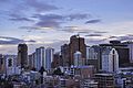 Skyline of Downtown La Paz
 Historic buildings in La Paz


