Top Qs
Timeline
Chat
Perspective
Lhatse County
County in Tibet, China From Wikipedia, the free encyclopedia

Remove ads
Lhatse County is a county of Xigazê in the Tibet Autonomous Region, China. It was established in 1959, with Lhatse Town as the county seat. In 1968, Quxar Town became the county seat.[2][3]

.png)


Lhatse County has a population of some 50,000 and is about 200 kilometers from Mount Everest (or Chomolungma). It is among the most impoverished counties in China.[4]
Remove ads
Administration divisions
Lhatse County is divided into 2 towns and 9 townships.[5][6]
Remove ads
Climate
Summarize
Perspective
Lhatse County recorded the highest temperature of 28.9 °C (84.0 °F) in locations above 4,000 meters above sea level.
Remove ads
Transport
The county is a juncture of China National Highway 219 (G219) which goes to Kashgar and China National Highway 318 (G318) which ends at the border with Nepal. To the west along the G318, a road splits off and runs to the Mount Everest base camp.
Gallery
 Map including Lhatse County area (ATC, 1971)
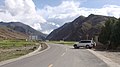

.jpg)
References
Wikiwand - on
Seamless Wikipedia browsing. On steroids.
Remove ads