Top Qs
Timeline
Chat
Perspective
Mount Aleutka
Mountain in Alaska, United States From Wikipedia, the free encyclopedia

Remove ads
Mount Aleutka is a 5,200-foot (1,585 m) mountain summit in the US state of Alaska.
.jpg)


Remove ads
Description
Mount Aleutka is located in the Fairweather Range of the Saint Elias Mountains.[1] It is set within Glacier Bay National Park and Preserve and is situated 12 miles (19 km) east of Mount Abbe. Although modest in elevation, topographic relief is significant as the summit rises up from tidewater of Scidmore Bay in four miles (6.4 km) and the west face rises 3,200 feet (975 m) above the Reid Glacier in 1.5 mi (2.4 km). The first ascent of the summit was made in 1969 by Eric G. Adelberger, Audra Adelberger, John and Pati Letcher, who also named this peak after the Letcher's 25-foot sailboat, Aleutka, which transported them around Glacier Bay.[2][3] The mountain's toponym has not been officially adopted by the U.S. Board on Geographic Names, and it will remain unofficial as long as the USGS policy of not adopting new toponyms in designated wilderness areas remains in effect.
Remove ads
Climate
Based on the Köppen climate classification, Mount Aleutka is located in a marine subpolar climate zone, with long, cold, snowy winters, and cool summers.[4] Weather systems coming off the Gulf of Alaska are forced upwards by the Saint Elias Mountains (orographic lift), causing heavy precipitation in the form of rainfall and snowfall. Winter temperatures can drop below 0 °F with wind chill factors below −10 °F. This climate supports the Reid, Scidmore, and Hugh Miller glaciers on the slopes of this peak. The months May through June offer the most favorable weather for viewing or climbing the peak.[5]
Remove ads
Gallery
 Summit from northeast
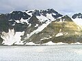 West aspect, above Reid Glacier
 Summit (left) with Scidmore Glacier
 Mount Aleutka reflected in Glacier Bay
 Summit (left) with Scidmore Glacier
 Summit centered, from northeast
 Summit to right

.jpg)

.jpg)
.jpg)
.jpg)
.jpg)


.jpg)
See also
References
External links
Wikiwand - on
Seamless Wikipedia browsing. On steroids.
Remove ads