Top Qs
Timeline
Chat
Perspective
Mount Churchill (British Columbia)
Mountain in the country of Canada From Wikipedia, the free encyclopedia

Remove ads
Mount Churchill is a mountain summit located in British Columbia, Canada.[3]


Remove ads
Description
Mount Churchill is a 1,996-meter-elevation (6,549-foot) peak situated 100 kilometers (62 miles) northwest of Vancouver, in the Sunshine Coast region, and is part of the Coast Mountains.[1] Precipitation runoff from Mount Churchill drains to Jervis Inlet via Glacial Creek and High Creek. Mount Churchill is more notable for its steep rise than for its absolute elevation. Topographic relief is significant as the summit rises 1,996 meters (6,549 feet) above tidewater of Jervis Inlet in five kilometers (3.1 miles).
Remove ads
Etymology
The mountain was named in 1860 by Sir George Henry Richards, probably after Francis Spencer, 1st Baron Churchill (1779–1845), the youngest son of George Spencer, 4th Duke of Marlborough.[3] The mountain's toponym was officially adopted March 31, 1924, by the Geographical Names Board of Canada.[2]
Climate
Based on the Köppen climate classification, Mount Churchill is located in the marine west coast climate zone of western North America.[4] Most weather fronts originate in the Pacific Ocean, and travel east toward the Coast Mountains where they are forced upward by the range (Orographic lift), causing them to drop their moisture in the form of rain or snowfall. As a result, the Coast Mountains experience high precipitation, especially during the winter months in the form of snowfall. Temperatures in winter can drop below −20 °C with wind chill factors below −30 °C.
Gallery
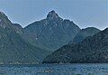 Mount Churchill from Jervis Inlet
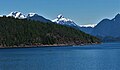 Mount Churchill (center) and part of Marlborough Highlands (left)


See also
References
External links
Wikiwand - on
Seamless Wikipedia browsing. On steroids.
Remove ads