Top Qs
Timeline
Chat
Perspective
Mount Faber
Hill in Bukit Merah, Singapore From Wikipedia, the free encyclopedia

Remove ads
Mount Faber, formerly Telok Blangah Hill, is a hill about 94 metres (308 ft) in height, located in the town of Bukit Merah in the Central Region of Singapore. It overlooks the Telok Blangah area and the western parts of the Central Area. The summit is accessible by Mount Faber Road[1] or Mount Faber Loop via Morse Road, but there are many footpaths or trails leading up the hill. The main paths are: Marang Trail, which leads from Marang Road at the HarbourFront MRT station (Exit D), and the Southern Ridges Park Connector which connects from Telok Blangah Hill Park, Kent Ridge Park, and Henderson Waves.

.svg)

It is a major tourist attraction, as it provides a panoramic view of the dense central business district within the Central Area.[2] Its slope includes a tower that is part of the Singapore cable car system that connects to HarbourFront and Sentosa.[3] It is accessible from the HarbourFront MRT station.
Remove ads
History

In 1972, the government spent S$63,910 to renovate the bunkers and turn Mount Faber into a landscaped scenic spot.[4] Construction on the S$2.94 million cable car system to link Mount Faber and Sentosa together also began.[5][3][6]
Geography
The vegetation around Mount Faber is a secondary rainforest that is smaller and less dense than on Bukit Timah Hill. Mount Faber is one of the higher hills in Singapore at 106 metres (348 ft),[7] lower than Bukit Timah Hill (164 m (538 ft)) and Bukit Gombak (133 m (436 ft)) and 113 m (371 ft)). It is separated from the adjacent slightly lower Telok Blangah Hill Park by Henderson Road.
Remove ads
Gallery

 Panoramic view of HarbourFront from Mount Faber Park
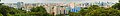 Panoramic view from Mount Faber, September 2008.

See also
References
External links
Wikiwand - on
Seamless Wikipedia browsing. On steroids.
Remove ads