Top Qs
Timeline
Chat
Perspective
Mount Shanks
Mountain in the country of Canada From Wikipedia, the free encyclopedia

Remove ads
Mount Shanks is a 2,838-metre (9,311-foot) mountain summit located in British Columbia, Canada.


Remove ads
Description
Mount Shanks is situated 10 km (6.2 mi) west of the Continental Divide on the boundary that Kootenay National Park shares with Mount Assiniboine Provincial Park.[4] The peak is part of the Ball Range which is a sub-range of the Canadian Rockies. Precipitation runoff from the peak's north and east slopes flows into tributaries of the Simpson River, whereas the west slope drains into the Vermilion River. Topographic relief is significant as the summit rises 1,600 metres (5,249 ft) above the Vermilion River in 4 km (2.5 mi) and 1,340 metres (4,396 ft) above the Simpson River in 3 km (1.9 mi).
Remove ads
History
This landform's original local name was "Folding Mountain" until the mountain was renamed in 1927 by Dominion Land Survey staff in honor of their colleague, the late Thomas Shanks, Assistant Director General of Surveys of Canada.[4][5] The mountain's toponym was officially adopted on July 31, 1927, by the Geographical Names Board of Canada.[3] The mountain was first climbed in September 1976 by P. Spear and R. Workum.[6]
Remove ads
Geology
Mount Shanks is composed of sedimentary rock laid down during the Precambrian to Jurassic periods. Formed in shallow seas, this sedimentary rock was pushed east and over the top of younger rock during the Laramide orogeny.[7]
Climate
Based on the Köppen climate classification, Mount Shanks is located in a subarctic climate zone with cold, snowy winters, and mild summers.[8] Winter temperatures can drop below −20 °C with wind chill factors below −30 °C.
Gallery
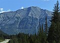 Southwest aspect from Highway 93
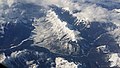 Mt. Shanks centered, aerial view looking north

.jpg)
See also
References
External links
Wikiwand - on
Seamless Wikipedia browsing. On steroids.
Remove ads