Top Qs
Timeline
Chat
Perspective
Outline of Arizona
U.S. state From Wikipedia, the free encyclopedia
Remove ads
The following outline is provided as an overview of and topical guide to the U.S. state of Arizona:
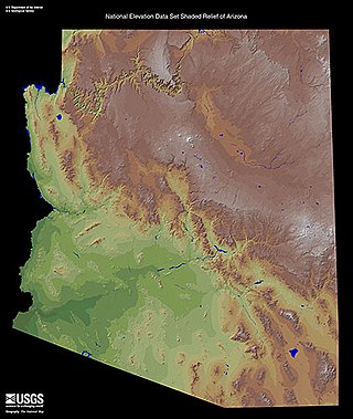
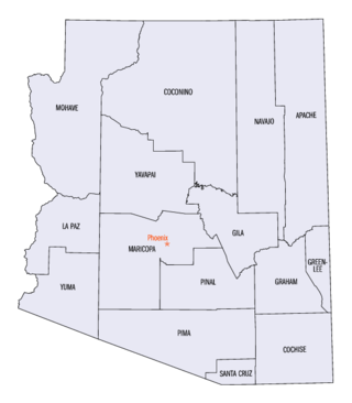
Arizona is a landlocked state in the Southwestern region of the United States, sharing the Four Corners region of the western United States with Colorado, New Mexico, and Utah. It also borders Nevada to the northwest and California to the west, and shares an international border with the Mexican states of Sonora and Baja California to the south and southwest. Its capital and largest city is Phoenix, which is the most populous state capital and fifth-most populous city in the United States. Arizona is divided into 15 counties.
Remove ads
General reference

- Names
- Common name: Arizona
- Pronunciation: /ˌærɪˈzoʊnə/ ⓘ ARR-iz-OH-nə
- Official name: State of Arizona
- Abbreviations and name codes
- Postal symbol: AZ
- ISO 3166-2 code: US-AZ
- Internet second-level domain: .az.us
- Nicknames
- Baby State (during the 47 years that Arizona was the newest state in the Union)[1]
- Copper State[1]
- Grand Canyon State (currently used on license plates)[1][2]
- Sunset State[1]
- Valentine State (Arizona gained statehood on February 14, 1912)[1]
- Common name: Arizona
- Adjectival: Arizona
- Demonyms
Remove ads
Geography of Arizona

- Geography of Arizona
- Arizona is: a U.S. state, a federal state of the United States of America
- Location
- Population of Arizona: 7,151,502 (2020 U.S. Census[3])
- Area of Arizona:
- Atlas of Arizona
Places in Arizona
- Places in Arizona
- Cemeteries in Arizona
- Historic places in Arizona
- National Natural Landmarks in Arizona
- National Parks in Arizona
- State parks in Arizona
Environment of Arizona
- Climate of Arizona
- Superfund sites in Arizona
- Wildlife of Arizona
- Fauna of Arizona
- Birds of Arizona
- Reptiles
- Fauna of Arizona
Natural geographic features of Arizona
Regions of Arizona
- Regions of Arizona
- Arizona Strip
- Coconino Plateau
- Colorado Plateau
- Grand Canyon
- Kaibab Plateau
- Mogollon Plateau
- Mogollon Rim
- Mojave Desert
- Monument Valley
- North Central Arizona
- Northeast Arizona
- Northern Arizona
- Oak Creek Canyon
- Phoenix Metropolitan Area
- Safford micropolitan area
- San Francisco Volcanic Field
- Sonoran Desert
- Southern Arizona
- Verde Valley
- White Mountains
Administrative divisions of Arizona

- The 15 counties of the state of Arizona
- Municipalities in Arizona
- Cities in Arizona
- State capital of Arizona: Phoenix
- Largest city in Arizona: Phoenix (fifth most populous city in the United States)
- List of city nicknames in Arizona
- Towns in Arizona
- Cities in Arizona
- Municipalities in Arizona
Demography of Arizona
Remove ads
Government and politics of Arizona
Branches of the government of Arizona
Executive branch of the government of Arizona
Legislative branch of the government of Arizona
Judicial branch of the government of Arizona
Law and order in Arizona
- Law of Arizona
- Cannabis in Arizona
- Capital punishment in Arizona
- Constitution of Arizona
- Gun laws in Arizona
- Law enforcement in Arizona
Military in Arizona
Local government in Arizona
History of Arizona
History of Arizona, by period
- Prehistory of Arizona
- European colonization of Arizona
- Spanish period of Arizona, 1539–1821
- Nueva Vizcaya, 1577–1733
- Pimería Alta, 1687–1733
- Spanish missions in the Sonoran Desert since 1687
- Pimería Alta, 1687–1733
- Sonora y Sinaloa, 1733–1821
- El Presidio Reál San Ignacio de Tubac established 1752
- Nueva Vizcaya, 1577–1733
- Spanish period of Arizona, 1539–1821
- Mexican period of Arizona, 1821–1848
- Sonora y Sinaloa, 1824–1830
- Sonora, 1830–1848
- Sonora y Sinaloa, 1824–1830
- Republic of Sonora, 1853–1854
- Gadsden Purchase of 1853–1854
- Confederate Territory of Arizona, 1861–1865
- Territory of Arizona, 1863–1912
- Loss of territory to the state of Nevada, 1867
- Powell Geographic Expedition of 1869
- James Reavis, The 'Baron of Arizona', 1870s–1890s
- Theodore Roosevelt Dam completed 1911
- State of Arizona becomes the 48th state admitted to the United States of America on February 14, 1912
- Grand Canyon National Park designated on February 26, 1919
- Hoover Dam completed 1936
- The Great Depression and the World Wars in Arizona
- Petrified Forest National Park designated on December 9, 1962
- Saguaro National Park designated on October 4, 1994
History of Arizona, by region
History of Arizona, by subject
- History of sports in Arizona
- History of universities in Arizona
- Uranium mining in Arizona
- Territorial evolution of Arizona
Remove ads
Culture of Arizona
The arts in Arizona
Sports in Arizona
Economy and infrastructure of Arizona
- Economy of Arizona
- Communications in Arizona
- Energy in Arizona
- Health care in Arizona
- Mining in Arizona
- Transportation in Arizona
- Airports in Arizona
- Roads in Arizona
Remove ads
Education in Arizona
See also
References
External links
Wikiwand - on
Seamless Wikipedia browsing. On steroids.
Remove ads