Top Qs
Timeline
Chat
Perspective
Page Peaks
Mountain of Mono County, California From Wikipedia, the free encyclopedia

Remove ads
Page Peaks is a 10,929-foot-elevation (3,331-meter) mountain summit located in the Sierra Nevada mountain range, in Mono County of northern California, United States.[1] The mountain is set in the Hoover Wilderness on land managed by Humboldt–Toiyabe National Forest. The summit is situated one mile outside the boundary of Yosemite National Park, and less than one mile east of line parent Camiaca Peak. Topographic relief is significant as the east aspect rises 1,400 feet (430 meters) above East Lake in one-quarter mile. This landform's toponym, which commemorates a miner and prospector named Page,[5] has been officially adopted by the United States Board on Geographic Names.[1]


Remove ads
Climate
Page Peaks is located in an alpine climate zone.[6] Most weather fronts originate in the Pacific Ocean, and travel east toward the Sierra Nevada mountains. As fronts approach, they are forced upward by the peaks (orographic lift), causing moisture in the form of rain or snowfall to drop onto the range. Precipitation runoff from this mountain drains into East Lake, thence West Fork Green Creek, which is a tributary of the Walker River.
Remove ads
Gallery
 East aspect
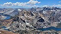 View from Dunderberg Peak looking west. Page Peaks is the dark triangle above East Lake. Summit Lake to left, Hoover Lakes lower left, East Lake lower right. Camiaca Peak (reddish) left of center, Gabbro Peak lower right.


References
External links
Wikiwand - on
Seamless Wikipedia browsing. On steroids.
Remove ads