Top Qs
Timeline
Chat
Perspective
Pagoda Mountain
Mountain in the United States From Wikipedia, the free encyclopedia

Remove ads
Pagoda Mountain is a 13,497-foot-elevation (4,114-meter) mountain summit in Boulder County, Colorado, United States.


Remove ads
Description
Pagoda Mountain is located one mile east of the Continental Divide in the Front Range of the Rocky Mountains.[4] The mountain is situated within Rocky Mountain National Park and is the fifth-highest peak in Boulder County.[8] Precipitation runoff from the mountain's south slope drains to North St. Vrain Creek via Hunters Creek and the north slope drains to Glacier Creek which is a tributary of the Big Thompson River. Topographic relief is significant as the summit rises 1,940 feet (590 meters) above Green Lake in one-half mile. The mountain's toponym was officially adopted in 1911 by the United States Board on Geographic Names and is so named because the mountain's shape resembles a pagoda.[5]
Remove ads
Climate
According to the Köppen climate classification system, Pagoda Mountain is located in an alpine subarctic climate zone with cold, snowy winters and cool to warm summers.[9] Due to its altitude, it receives precipitation all year, as snow in winter, and as thunderstorms in summer, with a dry period in late spring.
See also
Gallery
 North aspect, from Mills Lake
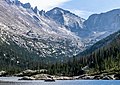 North aspect, from Mills Lake
 Longs Peak (left) and Pagoda Mountain (right)
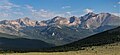 Left to right: Mount Alice, Chiefs Head Peak (centered), Pagoda Mountain, Longs Peak, Mount Meeker. Southeast aspect viewed across Wild Basin.
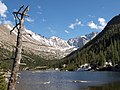 Pagoda Mountain centered


.jpg)
.jpg)
References
External links
Wikiwand - on
Seamless Wikipedia browsing. On steroids.
Remove ads