Top Qs
Timeline
Chat
Perspective
Samarskyi District
Urban district in Dnipro, Ukraine From Wikipedia, the free encyclopedia

Remove ads
The Samarskyi District (Ukrainian: Самарський район) is an urban district of the city of Dnipro, in southern Ukraine.[4] It is located at the confluence of the Dnieper and Samara rivers in the eastern and southeastern parts of the city.

|
Remove ads
History
The district was created on 6 April 1977[5] out of the neighborhood of Samar previously in the Industrialnyi District and the newly added cities of Prydniprovsk (1956–1977) and Ihren (1959–1977) as well as a historic Cossack settlement of Chapli.[1][5] Archeologic founds suggest that Samar existed in 1524.[6] Archaeologists of the Dnipro National University have discovered artifacts there dated around 1520s.[7]
The town of Prydniprovsk was created around the Prydniprovsk State District Power Station (DRES), today a thermal power station that was built in 1954, while the town of Ihren was created around the Ihren Rail Station, which still exists since 1873.[5] They were both absorbed into the boundaries of the Samarskyi District.[5]
Samarskyi District did not escape the Russian aerial attacks on Dnipro (of the Russian invasion of Ukraine); a Russian strike on the night of 26 to 27 January, 2025 damaged three high-rise residential buildings and industrial buildings in the district.[8]
Remove ads
Population
Language
Distribution of the population by native language according to the 2001 census:[9]
| a Those who did not indicate their native language or indicated a language that was native to less than 1% of the local population. |
Neighborhoods
Gallery
 Prydniprovsk Power Plant
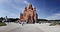 Church
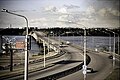 South bridge

.jpg)

References
External links
Wikiwand - on
Seamless Wikipedia browsing. On steroids.
Remove ads