Top Qs
Timeline
Chat
Perspective
Shevchenkivskyi District, Dnipro
Urban district in Dnipro, Ukraine From Wikipedia, the free encyclopedia

Remove ads
The Shevchenkivskyi District (also Shevchenko District; Ukrainian: Шевченківський район) is a right-bank urban district of the city of Dnipro, located in southern Ukraine.[3] It is formerly known as Babushkinskyi District.[4]


|
Remove ads
History
The district was formed on 12 April 1973 from the territory of Zhovtnevyi, Kirovskyi and Krasnohvardiiskyi districts and was named after Russian Bolshevik revolutionary Ivan Babushkin. On 26 November 2015, in compliance with to comply with decommunization laws, the Dnipropetrovsk City Council renamed this district to its current name.[5][4] The district is now named after the poet, writer, artist and political figure Taras Shevchenko.[6]
Remove ads
Population
Language
Distribution of the population by native language according to the 2001 census:[7]
| a Those who did not indicate their native language or indicated a language that was native to less than 1% of the local population. |
Notable places
- Dnipro Main Post Office
- Dnipro City Council
- Holy Trinity Orthodox Cathedral
Neighborhoods
- City centre (TsUM)
- Pidstantsiia
- 12th Kvartal
- Topolia
- Koreia
- Myrne
- Mlyny
- Krotova
Main streets
- Prospekt Dmytra Yavornytskoho (Dmytro Yavornytsky Avenue), former Yekaterininsky and Karla Marksa
- Sicheslavska naberezhna (Sicheslav Embankment), former Naberezhna Lenina
- Vulytsia Sviatoslava Khorobroho (Sviatoslav the Brave Street), former Bazarna and Chkalova
- Vulytsia Mykhaila Hrushevskoho (Mykhailo Hrushevsky Street), former Kazanska and Karla Libknekhta
- Vulytsia Sichovykh Striltsiv (Sich Riflemen Street), former Oleksandrivska and Artema
- Prospekt Bohdana Khmelnytskoho (Bohdan Khmelnytsky Avenue), former Dnipropetrovska street and Heroiv Stalinhrada street
- Vulytsia Panikakhy (Panikakha Street)
- Zaporizke Shose (Zaporizhzhia Chaussée)
Note: In May 2015, President of Ukraine Petro Poroshenko signed a bill into law, that started a six-month period for the removal of communist monuments and the mandatory renaming of settlements with names related to Communism.[8] Hence, the topography of Dnipro was renamed in order to comply with this decommunization law.[9] The city's name also changed from Dnipropetrovsk to its current name Dnipro in 2016.[10]
Remove ads
Gallery
 Dnipro Main Post Office
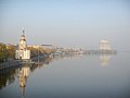 Dnipro river embankment of Shevchenkivskyi District
 Dmytro Yavornytsky Avenue in Shevchenkivskyi District
 European Square
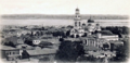 Shevchenkivskyi District in 1910 with the Holy Dormition Cathedral destroyed by the Soviet Union in 1936


References
Wikiwand - on
Seamless Wikipedia browsing. On steroids.
Remove ads