Top Qs
Timeline
Chat
Perspective
Sayres Benchmark
Mountain in Colorado, United States From Wikipedia, the free encyclopedia

Remove ads
Sayres Benchmark is a 13,746-foot-elevation (4,190-meter) mountain summit in Chaffee County, Colorado, United States.


Remove ads
Description
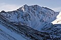
Sayres Benchmark is located three miles (4.8 km) east of the Continental Divide in the Collegiate Peaks which are a subset of the Sawatch Range. The mountain is set on the boundary of the Collegiate Peaks Wilderness on land managed by San Isabel National Forest.[1] The highest peak in Colorado and the Rocky Mountains, Mount Elbert, is 7.46 miles (12.01 km) north-northeast of Sayres Benchmark, and the fifth-highest, La Plata Peak, is less than two miles to the northeast.[2] Sayres ranks as the 130th-highest summit in Colorado.[1] Precipitation runoff from the mountain's south slope drains into Clear Creek, whereas the north slope drains to Lake Creek, and both are tributaries of the Arkansas River. Topographic relief is significant as the summit rises 2,950 feet (899 m) above North Fork Clear Creek in 1.5 miles (2.4 km). An ascent of Sayres involves 10 miles of hiking with 3,500-feet of elevation gain.[3] In winter the peak offers excellent ski mountaineering on its rugged north face.[4]
Remove ads
Climate
According to the Köppen climate classification system, Sayres Benchmark is located in an alpine subarctic climate zone with cold, snowy winters, and cool to warm summers.[5] Due to its elevation, it receives precipitation all year, as snow in winter and as thunderstorms in summer, with a dry period in late spring. Climbers can expect afternoon rain, hail, and lightning from the seasonal monsoon in late July and August.
Remove ads
Gallery
 North face
 Southeast aspect
 Sayres Benchmark in winter


See also
References
External links
Wikiwand - on
Seamless Wikipedia browsing. On steroids.
Remove ads