Top Qs
Timeline
Chat
Perspective
Solomon Temple (Grand Canyon)
Landform in the Grand Canyon, Arizona From Wikipedia, the free encyclopedia

Remove ads
Solomon Temple is a 5,121-foot-elevation (1,561-meter) summit located in the Grand Canyon, in Coconino County of northern Arizona, USA.[2] It is situated four miles north of Moran Point, 3.5 miles east of Newberry Butte, and 1.5 mile southeast of Rama Shrine, its nearest higher neighbor. Topographic relief is significant as it rises 2,500 feet (760 meters) above the Colorado River in less than one mile.


Solomon Temple was named after historical king Solomon by geologist François E. Matthes, following Clarence Dutton's practice of naming geographical features in the Grand Canyon after mythological deities and heroic figures.[3][4] This feature's name was officially adopted in 1906 by the U.S. Board on Geographic Names.[2]
Solomon Temple is a butte composed of Mississippian Redwall Limestone, which overlays shale of the Cambrian Tonto Group.[5] The Solomon Temple Member of the Dox Formation is so named because of exposures 2.4 kilometers northeast of this butte.[6]
According to the Köppen climate classification system, Solomon Temple is located in a Cold semi-arid climate zone.[7]
Remove ads
See also
Gallery
 Solomon Temple centered in lower half of frame. East aspect from Desert View.
 Solomon Temple
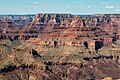 Solomon Temple in lower left. From the southeast.
Wotans Throne, Vishnu Temple, and Rama Shrine in the center. East-southeast aspect


.jpg)
References
External links
Wikiwand - on
Seamless Wikipedia browsing. On steroids.
Remove ads