Top Qs
Timeline
Chat
Perspective
Tinambac
Municipality in Camarines Sur, Philippines From Wikipedia, the free encyclopedia

Remove ads
Tinambac, officially the Municipality of Tinambac (Central Bikol: Banwaan kan Tinambac; Tagalog: Bayan ng Tinambac), is a municipality in the province of Camarines Sur, Philippines. According to the 2020 census, it has a population of 70,176 people.[5]


.svg)
Remove ads
History
The town of Tinambac was considered to be a trading center of villages surrounding the eastern side of Mt. Isarog. It was in this place where tobacco, then a prohibited product, was exchanged by the townspeople of Tinambac.
Its establishment as a separate municipality occurred during the latter part of the 18th century and this was known as the mission post of Himoragat. In 1829 when the Spanish administration divided the province of Camarines Sur into four districts, Tinambac fall under the District of Isarog.
A church was built atop a hill which still stands at present where the residents of this simple town give way to the celebration of its fiesta every 17th day of May. St. Pascual Baylon is the patron saint of this town.
Remove ads
Geography
Summarize
Perspective
Barangays
Tinambac is politically subdivided into 44 barangays. Each barangay consists of puroks and some have sitios.
- Agay-Ayan
- Antipolo
- Bagacay
- Banga
- Bolaobalite
- Bani
- Bataan
- Binalay (Poblacion)
- Buenavista
- Buyo
- Cagliliog
- Caloco
- Camagong
- Canayonan
- Cawaynan
- Daligan
- Filarca (Poblacion)
- La Purisima (Poblacion)
- Lupi
- Magsaysay (Camp 4)
- Magtang
- Mananao
- La Medalla (Mile 9)
- New Caaluan
- Olag Grande
- Olag Pequeño
- Old Caaluan
- Pag-Asa
- Pantat
- Sagrada (Camp 6)
- Salvacion
- San Antonio
- San Isidro (Poblacion)
- San Jose (Tiltilan)
- San Pascual (Poblacion)
- San Ramon (Camp 7)
- San Roque
- San Vicente
- Santa Cruz (Poblacion)
- Sogod
- Tambang
- Tierra Nevada
- Union
- Salvacion Poblacion
Climate
Remove ads
Demographics
In the 2020 census, the population of Tinambac was 70,176 people,[12] with a density of 200 inhabitants per square kilometre or 520 inhabitants per square mile.
Bikol is the predominant language.
Economy
Poverty incidence of Tinambac
10
20
30
40
50
60
2000
58.17 2003
54.70 2006
51.30 2009
53.20 2012
47.40 2015
51.36 2018
36.77 2021
47.71 Source: Philippine Statistics Authority[13][14][15][16][17][18][19][20] |
Total agricultural area is estimated to be 17,230 hectares (42,600 acres), 96% of which are planted with coconut. Only around 4% are devoted to rice, corn, banana and root crops. Fishponds cover around 464 hectares (1,150 acres) or 1.8% of the total agricultural area.
Remove ads
Infrastructure
- Communication facilities
- 1 Post Office located in the Poblacion, staffed by a Post Master and mail carriers
- Telegraph service offered by local branch of National Telecommunications Office
- Branches of RCPI and LBC Air Cargo
- Land line communication facilities
- Health services
- Tinambac Municipal Hospital
- Medicare Community Hospital - Sogod, Tinambac
- RRB Maternity, Family Planning, and Lying-in Clinic
Remove ads
Gallery
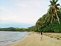 Caloco Beach
 View of Mount Isarog from Barangay San Antonio
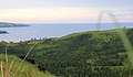 View of San Miguel Bay from Barangay San Antonio


References
External links
Wikiwand - on
Seamless Wikipedia browsing. On steroids.
Remove ads