Top Qs
Timeline
Chat
Perspective
Tuaran District
District in Sabah, Malaysia From Wikipedia, the free encyclopedia

Remove ads
The Tuaran District (Malay: Daerah Tuaran) is an administrative district in the Malaysian state of Sabah, part of the West Coast Division which includes the districts of Kota Belud, Kota Kinabalu, Papar, Penampang, Putatan, Ranau and Tuaran. The capital of the district is in Tuaran Town and the administrative area includes the entire boundary of Tuaran District, covering an area of 116,500 hectares (287,875 acres).[1] Tuaran also one of the districts in Sabah located near Kota Kinabalu, and it is considered part of the Greater Kota Kinabalu area.[2]

St. Andrews Anglican church was consecrated on 12 November 1967 by Roland Koh.[3]
Remove ads
Etymology
Summarize
Perspective
The origin of the name of "Tuaran" is somewhat uncertain as a settlement had existed since before the arrival of the British. One of the earliest recorded evidence of the use of Tuaran is through the letter of Stamford Raffles. After he became the governor of Java in 1813, he requested the British secretary in India to give him permission to enter the northern Borneo area after being invited by the Sultanate of Brunei.[4] The Sultan of Brunei request help from Raffles as the waters around Jawaran (Tuaran) and Jampasoo (Tempasuk) have been infected with piracy. The letter stated:
The present Sultan of Borneo Proper (Brunei) is understood to be well disposed not given the encouragement of piratical enterprise, notwithstanding the shelter is accorded to pirates in almost every river in his domain, a number of petty states having arisen beyond the reach of his authority and control. The most prominent of these states are the states of Jawaran (Tuaran) and Jampasoo (Tempasuk) to the northward of Borneo Proper……… It has been reported that Jawaran send about 50 prows (perahu) belonging to this states is estimated about 150 with from one to two hundred guns. The large prows armed with 10 feet long probably 12 and 18 paunders. Their crews consisting 80-200 men. The lanoons are the most considerable, formidable of these eastern pirates. There is little doubts that we the (East India Company) should be justified in the immediate destruction of these prows.[4]
Remove ads
Administration
Summarize
Perspective


Tuaran District Council
The Tuaran District Council oversees the administration of various areas within Tuaran district, including Pantai Dalit, Sulaman, Tamparuli, and Kiulu.[5] It was established on January 1, 1958,[5] under the "Rural Government Ordinance Cap. 132" and began operating as a Local Authority on January 1, 1962, under the Local Authorities Ordinance 1961 and the Tuaran District Council Deed 1961.[5]
The administrative center of the Tuaran District Council is situated in the town of Tuaran.[5] Prior to this, the council operated from the Small Secretariat Building in the town. In 1994, the proposal to build a new office complex for the council was greenlit, and construction work commenced.[5] By the end of 1997, the new building, known as the Tuaran District Council Complex, was finished and officially occupied.[5]
Administrative division
Tuaran District includes:
Members of Sabah State Legislative Assembly
Towns
There are 4 Towns in Tuaran District:[6]


Sub-District
Tamparuli became a sub-district in 1977,[7] followed by Kiulu in 2018.[8] There are 2 Sub-District in Tuaran District:
Remove ads
Geography
The Tuaran district is located in the northwest of Sabah, bordered by:
- Kota Belud district to the east
- Ranau district to the southeast
- Penampang and Tambunan districts to the south
- Kota Kinabalu district to the west
- The South China Sea to the northwest
The topography of the Tuaran District mostly consists of lowland areas along the coastline, while the inland areas are characterized by highlands and hilly terrain. The highest point in the Tuaran District is Mount Alab, which reaches an elevation of 1,951 meters. The longest river in this district is the Tuaran River, and the largest island is Pulau Lipan.
Demographics
According to the last census in 2020, the population of the district is estimated to be around 135,665,[10] mainly Dusun and Bajau people as well a significant number of Chinese and Malay. As in other districts of Sabah, there are a significant number of illegal immigrants from the nearby southern Philippines, mainly from the Sulu Archipelago and Mindanao, many of whom are not included in the population statistics.
Remove ads
Tourism
Summarize
Perspective
Tourist attractions in Tuaran include the Mengkabong and Penimbawan water villages, which are villages of stilt houses built over the seashore by the Bajau people, and the Ling San Pagoda (Traditional Chinese: 龍山塔), a nine-storey Buddhist pagoda situated just outside the town centre. The main tourist resorts in Tuaran are the Mimpian Jadi Resort and Shangri-La's Rasa Ria Resort. In addition to food and lodging, these resorts offer various other activities such as golfing and water sports.
Other Attraction
Remove ads
Gallery
 An-Nur Mosque.
 St. Andrew Anglican Church.
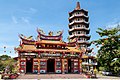 Ling San Pagoda.
 Tuaran canopy walk.
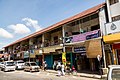 Tuaran shoplots.
 Tuaran roundabout.


.jpg)


See also
References
Further reading
External links
Wikiwand - on
Seamless Wikipedia browsing. On steroids.
Remove ads