Top Qs
Timeline
Chat
Perspective
Ute Mountain (New Mexico)
Mountain in New Mexico, United States From Wikipedia, the free encyclopedia

Remove ads
Ute Mountain is a 10,093-foot elevation (3,076 m) summit located in Taos County, New Mexico, United States.
.jpg)


Remove ads
Description
Ute Mountain is part of the Taos Mountains which are a subset of the Sangre de Cristo Mountains.[3] The isolated landmark is the highest point of the Cerro del Yuta Wilderness and Rio Grande del Norte National Monument which is administered by the Bureau of Land Management.[4] The remote mountain is situated 35 miles north of the town of Taos and four miles south of the New Mexico–Colorado border. Ute Mountain is a free-standing, dacitic, extinct Pliocene volcanic cone set within the Taos Plateau volcanic field.[8] Ute Mountain has a base diameter of five miles and topographic relief is significant as the summit rises 2,500 feet (760 meters) above the surrounding sagebrush-covered basalt plains.[2] The slopes of the mountain are covered with stands of pinyon pine, ponderosa pine, aspen and Douglas fir.[9] Precipitation runoff from the mountain drains to the Rio Grande which flows through a gorge along the western base of the mountain.
Remove ads
Etymology
The mountain is also known in Spanish as "Cerro del Yuta" (Mountain of the Ute).[10] The origin of the word Ute is unknown; it is first attested as Yuta in Spanish documents. The mountain is named after the Ute people whose self-designation is Núuchi-u, meaning 'the people'.[11] The state of Utah is also named after the Ute people. This landform's toponym has been officially adopted by the United States Board on Geographic Names,[5] and has appeared in publications since at least 1875.[12]
Remove ads
Gallery
 Ute Mountain and Rio Grande
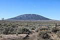 Northeast aspect from Jaroso, Colorado
 East aspect from Costilla, New Mexico


.jpg)

See also
References
External links
Wikiwand - on
Seamless Wikipedia browsing. On steroids.
Remove ads