Top Qs
Timeline
Chat
Perspective
Willard Peak
Mountain in Box Elder and Weber counties in Utah, United States From Wikipedia, the free encyclopedia

Remove ads
Willard Peak (Shoshoni: Sogo goi)[6] is a 9,763-foot elevation (2,976 m) mountain summit located on the common border Box Elder County shares with Weber County in Utah, United States.
.jpg)


Remove ads
Description
Willard Peak is situated on the crest of the Wasatch Range which is a subset of the Rocky Mountains, and it is set on land managed by Wasatch-Cache National Forest. The summit is the highest point in Weber County as well as the Northern Wasatch Range.[2] The town of Willard is four miles to the northwest and Ben Lomond Mountain is 1.5 mile to the southeast. The peak is located at the head of Willard Creek and precipitation runoff from the mountain's slopes ultimately drains to Great Salt Lake. Topographic relief is significant as the summit rises over 5,500 feet (1,700 meters) above Willard Bay in four miles.
Remove ads
History
This landform's toponym, which refers to Willard Richards (1804–1854), has been officially adopted by the U.S. Board on Geographic Names.[7][4] The peak was climbed in 1877 by Samuel Escue Tillman and Rogers Birnie of the Hayden Survey and used as a triangulation station.[8] The survey referred to the peak as "Willard's Peak" in an 1879 published report, and "Willard Peak" has appeared in publications since at least 1895.[9] Back then, "Willard's Peak" might have referred to present-day Ben Lomond Mountain.
Remove ads
Gallery
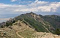 Willard Peak from Ben Lomond Trail
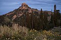 Northwest aspect
 Southeast aspect
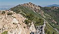 Willard Peak from Ben Lomond Trail
 Northwest slope of Willard to the right. (summit not visible)
 Willard Peak and Ben Lomond (right)
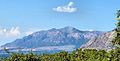 Willard Peak and Ben Lomond from the south


.jpg)


See also
References
External links
Wikiwand - on
Seamless Wikipedia browsing. On steroids.
Remove ads