Tiedosto:NASA_-_Visible_Earth,_Lakes_of_the_African_Rift_Valley.jpg
From Wikipedia, the free encyclopedia
Tämän esikatselun koko: 800 × 523 kuvapistettä. Muut resoluutiot: 320 × 209 kuvapistettä | 640 × 419 kuvapistettä | 1 000 × 654 kuvapistettä.
Alkuperäinen tiedosto (1 000 × 654 kuvapistettä, 127 KiB, MIME-tyyppi: image/jpeg)
| Tämä tiedosto on tiedostotietokanta Wikimedia Commonsista. Tiedot kuvaussivulta näkyvät alla. |  |
Tiedoston kuvaussivu Commonsissa |
Yhteenveto
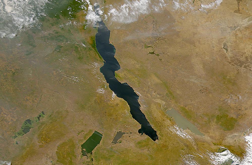
| KuvausNASA - Visible Earth, Lakes of the African Rift Valley.jpg | The lakes of the African Rift Valley exhibit wide variations in water color as can be seen in this SeaWiFS image. From left to right the lakes are: Lake Upembe, Lake Mweru, Lake Tanganyika (largest), and Lake Rukwa. This image spans the southeastern corner of the Democratic Republic of the Congo, northeastern Zambia, and southern Tanzania. |
| Päiväys | |
| Lähde | http://visibleearth.nasa.gov/view_rec.php?id=757 |
| Tekijä | SeaWiFS Project, NASA/Goddard Space Flight Center, and ORBIMAGE |
| This image appeared on English Wikipedia's Main Page in the Did you know? column on 26 March 2004 (see archives). |
Lisenssi
| Public domainPublic domainfalsefalse |
| This image is from the Sea-viewing Wide Field-of-view Sensor (SeaWiFS) Project and more than 5 years old.
Satellite data captured by the SeaWIFS sensor are released into the public domain 5 years after capture. Data less than five years old can be re-used only for educational or scientific purposes; any commercial use of such images must be coordinated with GeoEye. [1] |
| Public domainPublic domainfalsefalse |
| This work has been released into the public domain by its copyright holder, GeoEye. This applies worldwide. Joissain maissa laki ei mahdollista tätä. Mikäli näin on: GeoEye myöntää kaikille oikeuden käyttää tätä teosta mihin tahansa tarkoitukseen ilman minkäänlaisia ehtoja, ellei laki vaadi ehtojen asettamista. Public domainPublic domainfalsefalse |
Kuvatekstit
Lisää yhden rivin pituinen kuvaus tästä tiedostosta
The lakes of the African Rift Valley
Kohteet, joita tässä tiedostossa esitetään
esittää
23. heinäkuu 2000
image/jpeg
Tiedoston historia
Päiväystä napsauttamalla näet, millainen tiedosto oli kyseisellä hetkellä.
| Päiväys | Pienoiskuva | Koko | Käyttäjä | Kommentti | |
|---|---|---|---|---|---|
| nykyinen | 25. syyskuuta 2005 kello 21.40 | | 1 000 × 654 (127 KiB) | Moyogo | from NASA [http://visibleearth.nasa.gov/view_rec.php?id=757] Category:Africa |
Tiedoston käyttö
Seuraavat 2 sivua käyttävät tätä tiedostoa:
Tiedoston järjestelmänlaajuinen käyttö
Seuraavat muut wikit käyttävät tätä tiedostoa:
- Käyttö kohteessa af.wikipedia.org
- Käyttö kohteessa als.wikipedia.org
- Käyttö kohteessa ar.wikipedia.org
- Käyttö kohteessa ast.wiktionary.org
- Käyttö kohteessa bar.wikipedia.org
- Käyttö kohteessa be.wikipedia.org
- Käyttö kohteessa bh.wikipedia.org
- Käyttö kohteessa ca.wikipedia.org
- Käyttö kohteessa cs.wikipedia.org
- Käyttö kohteessa de.wikipedia.org
- Käyttö kohteessa de.wiktionary.org
- Käyttö kohteessa en.wikipedia.org
- Käyttö kohteessa eo.wikipedia.org
- Käyttö kohteessa es.wikipedia.org
- Käyttö kohteessa eu.wikipedia.org
- Käyttö kohteessa fa.wikipedia.org
- Käyttö kohteessa fr.wikipedia.org
- Lac Tanganyika
- Fièvre de la vallée du Rift
- Portail:Zambie/Lumière sur...
- Portail:Burundi/Lumière sur...
- Milieu naturel des poissons d'eau douce
- Lacs de la vallée du Grand Rift
- Lac Rweru
- Lac Cyohoha Sud
- Liste des sites Ramsar en Zambie
- Vallée de rift
- Liste des lacs au Burundi
- Modèle:Palette Lacs du Burundi
- Käyttö kohteessa fr.wiktionary.org
- Käyttö kohteessa ga.wikipedia.org
- Käyttö kohteessa he.wikipedia.org
- Käyttö kohteessa hi.wikipedia.org
- Käyttö kohteessa id.wikipedia.org
- Käyttö kohteessa is.wikipedia.org
- Käyttö kohteessa ka.wikipedia.org
- Käyttö kohteessa ku.wikipedia.org
- Käyttö kohteessa ky.wikipedia.org
- Käyttö kohteessa ln.wikipedia.org
Näytä lisää tämän tiedoston järjestelmänlaajuista käyttöä.